
19.8
PDI
8.8 mi
DISTANCE
3,243 ft
GAINED
6.6 %
AVG. GRADE
FULL CLIMB STATS
INTRO
PLAN YOUR ROUTE
 We've partnered with Sherpa-Map.com to bring you the best route planning tool. With a PRO Membership you can use this climb as a reference when creating your route.
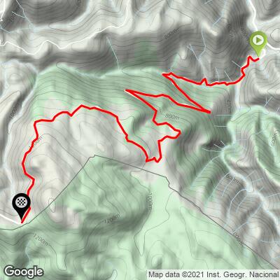
Arnoztegiko Lepoa climbs 14.1 km (8.8 mi) and gains 988 m (3,243 ft) at a 6.6% average, from 304 m (996 ft) to 1,231 m (4,038 ft), with about 61 m (201 ft) of descending along the way, most of it in one short dip around km 9-10.
The grade is unusually even for a Pyrenean pass. The steepest 100 m (0.1 mi) reaches 11.3%, the steepest 0.5 km 10.4%, the steepest kilometer 10.1%, the steepest 2 km 9.8% and the steepest 5 km 9.1%, and even the steepest 10 km averages 7.6%.
The opening 4 km (2.5 mi) are the gentlest at about 7%, the stretch from roughly km 4 to km 6 is the hardest sustained effort at close to 9.5%, and the final 4 km (2.5 mi) after the dip settle to about 6%.
Roadway: The climb follows narrow Basque mountain roads (the D301 and D428) that riders describe as paved, though the surface is average to bumpy rather than smooth. Reports differ on the very top - some mention a short loose section near the ridge, others a fully paved road - so expect mostly asphalt with the possibility of gravel near the finish. The descent toward Arnéguy is reported to be rough, and most riders return the way they came.
Traffic: Light. This is a farm and forest road, and livestock and Camino de Santiago pilgrims on the D428 near the ridge are a bigger consideration than cars.
Parking: There is no dedicated cycling lot at the start. Roadside parking in Estérençuby near the church and mairie, described on our Col d'Errozate page, is the practical choice, a short roll from this start.
Gear: Steady 9-10% pitches through the middle of the climb make a compact crankset with a 30- to 34-tooth cog the sensible choice. Much of the road is shaded by forest and cooler than the valley, but the ridge is exposed, so carry a windproof layer - riders have reported fog at the top.
Provisions: There are no services on the climb, so carry food and water. The nearest shops and cafes are in Saint-Jean-Pied-de-Port, about 7 km (4.3 mi) north.
Before heading out on any cycling adventure check out our Things to Bring on a Cycling Trip and use our interactive check list to ensure you don't forget anything.
Our Col d'Errozate page covers Estérençuby itself, its lodging and the Iraty side, and our Col d'Elhursaro (Arnéguy) and Alto de Beillurti pages cover the Arnéguy side, which reaches this same ridge by much steeper roads. This page is about the col itself and the country beyond it.
The col sits on the border, usually without signs, and riders report a small car park used by hikers heading for the Urkulu tower on the GR 11. East of the ridge the Iraty forest, a summer and winter-sports hub with chalets, a restaurant and a small grocery, makes a rewarding target for strong riders, and Chalet Pedro, a traditional Basque restaurant in the forest about 500 m from the Iraty plateau, is worth a call to check hours (+33 5 59 28 55 98).
Saint-Jean-Pied-de-Port remains the best base for a multi-day trip. The col catches fog and wind, so check conditions with our Weather tool before you head up.
ROUTE MAP
MEMBER RATING
CURRENT WEATHER
PJAMM TRIPS ADVENTURE STARTER BUNDLES
Check out PJAMM Adventure's prepackaged (self-guided) cycling trips. They will help you plan, document and conquer your next adventure.
NEARBY CLIMBS (0) RADIAL PROXIMITY
FROM No Climbs Found
MEMBER REVIEWS & COMMENTS
Let us know what you thought of this climb. Signup for our FREE membership to write a review or post a comment.
Already have an account?
LOG IN HERE
