
21
PDI
5.8 mi
DISTANCE
2,785 ft
GAINED
9 %
AVG. GRADE
FULL CLIMB STATS
INTRO
Col d'Elhursaro climbs 9.4 km (5.8 mi) through the French Basque Pyrenees, gaining 849 m (2,785 ft) at a 9.0% average grade from the Nive d'Arnéguy valley (308 m / 1,011 ft) to the col at about 1,149 m (3,770 ft). By our rankings it is #149 in France and #895 in the world.
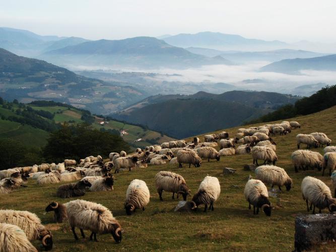
The grade rarely lets up. The steepest kilometer averages 13.5%, the steepest 500 m (0.3 mi) 14.9% and the steepest 100 yards 16.2%, and the only real recovery comes around kilometer 5, where the road drops to about 7% before stiffening again. Higher up the trees give way to open grazing land where sheep graze beside the road, and riders report vultures overhead and a vulture feeding station near the route.
The col is exposed, and riders have turned back here in strong wind, so choose a calm day and carry a windproof. If you still have legs at the top, the road beyond eases for about 4 km (2.5 mi) to the Col d'Arnostéguy on the border ridge.
PLAN YOUR ROUTE
 We've partnered with Sherpa-Map.com to bring you the best route planning tool. With a PRO Membership you can use this climb as a reference when creating your route.
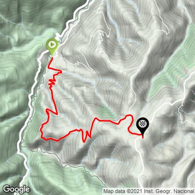
 9.0% average grade over 9.4 km (5.8 mi). The steepest 100 yards runs at 16.2%, the steepest 500 m (0.3 mi) at 14.9% and the steepest kilometer at 13.5%. Over longer stretches it stays tough: the steepest 2 km (1.2 mi) averages 11.8% and the steepest 5 km (3.1 mi) 10.3%.
The first 4 km (2.5 mi) average 9.1%, kilometer 5 eases to about 7% for a short breather, the sixth kilometer is the hardest, and the final kilometers settle closer to 8% before the grade backs off near the col.
Roadway: Our surface data shows the route paved from start to finish. It is a narrow mountain road, and rider reports describe it as bumpy, with short recoveries between steep ramps, so wider tires help on both the climb and the descent.
Traffic: Minimal. Riders describe magnificent landscapes and very little motor traffic; sheep and other livestock are the more likely thing to slow you down.
Parking: Leave the car in Arnéguy. Our Col d'Elhursaro (Arnéguy) page covers the village itself. Another option is to ride in from Saint-Jean-Pied-de-Port, about 7 km (4.3 mi) up the valley road along the Nive d'Arnéguy, which doubles as a warm-up and gives you the town's shops and cafes before the climb.
Gear: With a 13.5% steepest kilometer, a compact crankset with a 32- or 34-tooth cog is the sensible choice. The col is windy, so pack a windproof layer for the exposed upper slopes and the descent.
Provisions: Carry food and water for the whole climb. Shops and restaurants are in Arnéguy and, in greater number, Saint-Jean-Pied-de-Port.
Before heading out on any cycling adventure check out our Things to Bring on a Cycling Trip and use our interactive check list to ensure you don't forget anything.
Saint-Jean-Pied-de-Port, about 7 km (4.3 mi) north on the valley road, is the base for this corner of the Basque Country. Founded in the 12th century as part of the Kingdom of Navarre, its citadel on Mendiguren hill was built in the 17th century on the ruins of a medieval castle and redesigned by Vauban in 1685. Two long-distance trails, the GR 65 (the Way of St. James) and the GR 10, pass through the area.
Our other pages around Arnéguy cover the village and its Camino history (Col d'Elhursaro (Arnéguy)), the guesthouse and ridge views side (Alto de Beillurti) and the Estérençuby valley (Col d'Errozate), so here is the wider valley instead. The Irouléguy AOP vineyards, about 250 hectares of terraced slopes across a dozen communes, and the Ossau-Iraty sheep's-milk cheese made in villages such as Mendive, Béhorléguy and Lecumberry near the Iraty forest are both worth a post-ride detour.
The col catches weather, so check current conditions with our Weather tool before you head up.
ROUTE MAP
MEMBER RATING
CURRENT WEATHER
PJAMM TRIPS ADVENTURE STARTER BUNDLES
Check out PJAMM Adventure's prepackaged (self-guided) cycling trips. They will help you plan, document and conquer your next adventure.
NEARBY CLIMBS (0) RADIAL PROXIMITY
FROM No Climbs Found
MEMBER REVIEWS & COMMENTS
Let us know what you thought of this climb. Signup for our FREE membership to write a review or post a comment.
Already have an account?
LOG IN HERE
