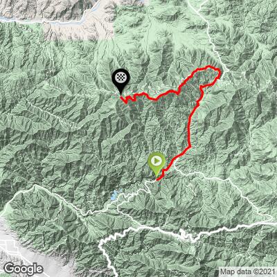
19.4
PDI
17.5 mi
DISTANCE
4,147 ft
GAINED
4 %
AVG. GRADE
FULL CLIMB STATS
INTRO
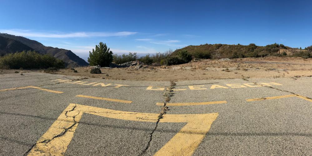
Ride up to an abandoned Cold War Nike Missile launch site.
This climb is just pure fun, and feels far more like exploring than working out, especially after you turn off onto the second half of the climb at Mill Creek. Don't be fooled by the modest 5.5 fiets: the 15 miles of climbing and rollers will make the last 2 miles at 10% after the missile site hurt especially bad.
PLAN YOUR ROUTE
See more details and tools regarding this climb's grade via our interactive Profile Tool.
Roadway:
The roadway on Angeles Forest Hwy is pristine. Traffic is light, but cars and motorcycles tend to drive fast around turns. The traffic significantly reduces once you turn onto Mt Gleason Road (mile 8.3) but the pavement quality declines.
Parking:
There are scenic pulloffs along Angeles Forest Hwy before the start of the climb (east) that are fine to park at for a few hours - from these it should be a short downhill until the start of the climb. An Angeles Forest recreation pass is required to park at a campsite, trailhead, or day-use site.
This climb is unsupported, especially once you turn onto Mount Gleason Road. Nearby fire stations with public water fountains/bottle fill ups:
Monte Cristo Fire Station (mile 2 - water was turned off when we rode Oct '21)
Mill Creek Fire Station (mile 8.3 - water could also be turned off)
Clear Creek Fire Station (not along route - water always on)
Before heading out on any cycling adventure check out our Things to Bring on a Cycling Trip and use our interactive check list to ensure you don't forget anything.
Check out our full ride suggestions in the Full Summary to plan your next ride around Mt Gleason.
Although Gleason is one of our local favorites and absolutely worth spending a day to ride, if you're traveling to LA to climb, we actually recommend focusing most of your efforts on rides like Glendora Mountain Road, Hwy 39 - Dawson Saddle, Crystal Lake, and even rides across town in Malibu (ocean views!)
To get to these, the best place to stay is farther east in Glendora, and to get to the latter, Malibu has some top hotels. If you plan on doing more than just riding while in LA, Santa Monica is our recommendation.
ROUTE MAP
MEMBER RATING
CURRENT WEATHER
PJAMM TRIPS ADVENTURE STARTER BUNDLES
Check out PJAMM Adventure's prepackaged (self-guided) cycling trips. They will help you plan, document and conquer your next adventure.
NEARBY CLIMBS (0) RADIAL PROXIMITY
FROM No Climbs Found
MEMBER REVIEWS & COMMENTS
Let us know what you thought of this climb. Signup for our FREE membership to write a review or post a comment.
Already have an account?
LOG IN HERE
whitoriginals
-Exceptional ride, prob underrated bc it takes effort to get to start.
-rode this october 19, 2022, temps mid80s bottom, 70 top, visibility unlimited from summit, sb mtns, mojave, tehachipis, downtown la, channel islands, mt. wilson, etc.
-went through 4 botts
-cfd chief at tujunga stn says avoid angeles forest road on weekends! drift drivers and motorcyclists cutting corners. if biker gets hit and goes over the side...they'll never find you.
-road q: first half excellent, next 1/3 ok, next 1/3 has a mile of chunky dirt and pavement over concrete strips. i rode a salsa cutthroat with 2.2 knobbies.
-park at picnic area on left immed after tunnel, which is immed after tujunga bridge.
-even better, just park at the top, pacifico campground, as the climb to there is plain vanilla socal uphill grind.
-nike missile silos...meh. bunch of old buildings and stuff.
-last two miles are very steep. don't go to the atm too early.
-if you're in socal, make this a priority