
19.3
PDI
14.7 mi
DISTANCE
3,893 ft
GAINED
4.8 %
AVG. GRADE
FULL CLIMB STATS
INTRO
PLAN YOUR ROUTE
 We've partnered with Sherpa-Map.com to bring you the best route planning tool. With a PRO Membership you can use this climb as a reference when creating your route.
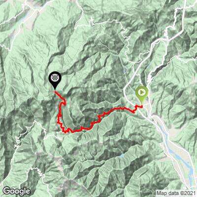
The climb averages 4.8% over 23.7 km (14.7 mi), but it comes in three distinct parts. The first 4 km (2.5 mi) out of Pontremoli average 5.0%. The next 10.2 km (6.3 mi) gain just 157 m (515 ft) at about 1.5%, including a short descent of roughly 1 km (0.6 mi) before San Lorenzo.
The final 9.5 km (5.9 mi) are the real climb, averaging 8.3%. The grade sits around 7-8% for the first few kilometers, then kicks up: the last 4 km (2.5 mi) average 10.1% and the final 3 km (1.9 mi) 10.6%. The steepest 500 m averages 14.4%, the steepest 1 km 13.9%, the steepest 2 km 12.1% and the steepest 5 km 9.8%.
Roadway: The climb is paved to the pass. From Pontremoli it follows the Via Valli di Zeri, a narrow, winding road up the valley, then climbs steeply past the Villaggio degli Aracci to the Zum Zeri ski area. The road on this side ends at the pass, so plan to descend the way you came, and take the steep final kilometers carefully on the way down.
Traffic: The Valle di Zeri is sparsely populated, and the road mainly serves its villages and the ski area at the top, so traffic is generally light.
Parking: To ride the full climb, park in Pontremoli and start from town. At the top, the pass has a large car park beside the refuge - an option for riders who only want to tackle the steep final section from Coloretta or Patigno.
Provisions: Pontremoli is the place to stock up. The refuge at the pass has a bar-restaurant and riders report a water point there, but it is listed as closed on Mondays, so don't rely on it without checking.
Gear: With 4 km (2.5 mi) above 10% at the end and ramps near 14%, a compact with a 32 or 34 tooth largest cog is a good idea.
Weather: The pass sits more than 1100 m (3600 ft) above Pontremoli and holds snow in winter. Bring a layer for the descent.
Before heading out on any cycling adventure check out our Things to Bring on a Cycling Trip and use our interactive check list to ensure you don't forget anything.
Pontremoli, the main town of upper Lunigiana, sits on the Via Francigena below the Passo della Cisa. Its Castello del Piagnaro houses the Museo delle Statue Stele Lunigianesi, the prehistoric carved stone figures found across the valley, and the Caffè degli Svizzeri in Piazza della Repubblica, a pastry shop dating to the 1800s, serves the local amor wafers and spongata. Try testaroli, Pontremoli's crêpe-like griddle bread dressed with pesto or pecorino. The town is also known as the home of the Premio Bancarella book prize, awarded since 1953.
Up the valley, look for agnello di Zeri on local menus, traditionally cooked with potatoes in a cast-iron testo. At the pass, the small chapel of the Madonna della Neve sits behind the beech woods. Pontremoli is also the start of several other climbs, including Passo Mistadella and Passo della Cisa, so use our Routes in the Area tool to see what else is nearby.
ROUTE MAP
MEMBER RATING
CURRENT WEATHER
PJAMM TRIPS ADVENTURE STARTER BUNDLES
Check out PJAMM Adventure's prepackaged (self-guided) cycling trips. They will help you plan, document and conquer your next adventure.
NEARBY CLIMBS (0) RADIAL PROXIMITY
FROM No Climbs Found
MEMBER REVIEWS & COMMENTS
Let us know what you thought of this climb. Signup for our FREE membership to write a review or post a comment.
Already have an account?
LOG IN HERE
