
16.3
PDI
7.8 mi
DISTANCE
2,696 ft
GAINED
6.5 %
AVG. GRADE
FULL CLIMB STATS
INTRO
Halfway up this climb there's a cave you can ride to in shorts and tour in a jacket. The Grotta di Bossea sits right beside the road about 4 km above Corsaglia, holds about 9°C all year, has an underground stream and waterfalls running through it, and has been open to visitors since 1874. The riding to get there is gentle - the SP232 follows the Corsaglia torrent up the valley at 3 to 5%, through Zitella and Bossea to the village of Fontane at km 6.4.
At Fontane the climb changes completely. The Strada della Penna leaves the valley and works up the mountainside on a narrow lane, 8 to 10% for most of the last 6 km, with the steepest kilometer at 11.1% near the top. In all it's 12.6 km (7.8 mi) with 822 m (2696 ft) of climbing at 6.5%, from 695 m to 1508 m.
The woods open up in the last kilometer, the view swings back over the valley you came up, and you finish on the grassy saddle at Sella Penna Soprana with the bare ridges of the Ligurian Alps around you. The asphalt carries on over the ridge toward the Colla del Prel above Prato Nevoso, so you don't have to come back the same way.
PLAN YOUR ROUTE
 We've partnered with Sherpa-Map.com to bring you the best route planning tool. With a PRO Membership you can use this climb as a reference when creating your route.
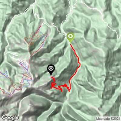
From Corsaglia, 695 m (2279 ft), to Sella Penna Soprana, 1508 m (4948 ft): 12.6 km (7.8 mi), 822 m (2696 ft) gained, 6.5% average. The steepest kilometer is 11.1% and the steepest 2 km average 9.9%.
Km 0-6.5, Val Corsaglia: an easy valley road at 2.5 to 5%, passing the Grotta di Bossea at km 3.8 and reaching Fontane at km 6.4.
Km 6.5-12.6, Strada della Penna: the real climb. It leaves Fontane with a ramp of about 12% and stays near 10% to km 7.5, then gives you a near-flat 500 m before settling at 8 to 10% all the way up. The last kilometer is the hardest, kicking back up to about 12% before it eases onto the saddle.
Roadway: Paved to the top. The SP232 up the Val Corsaglia is a wider provincial road in good shape. The Strada della Penna above Fontane is a different thing: one lane, patched, with gravel at the edges and leaves on the surface in the woods, getting thinner and rougher in the last kilometer, and the very top is a gravel turnout. The upper road isn't cleared in winter, so treat this as a late-spring to autumn climb.
Traffic: Light on the SP232, with more cars around the Grotta di Bossea on weekends and holidays. Above Fontane it's very quiet - residents of Vinè, farm traffic and the odd hiker's car.
Parking: Park in Corsaglia, at the bottom of the climb - mountain bikers heading for the Colle del Prel trails leave their cars at the bridge over the Corsaglia torrent. To ride only the steep half, start in Fontane at km 6.4 instead.
Gear: The first half is warm-up gearing; the Strada della Penna is where a compact and a 30 or 32 at the back earn their keep. Tires of 28 mm or wider make the patched upper road more comfortable, and take a layer - the saddle is more than 800 m above Corsaglia and open to the wind. If you're stopping at the cave, bring shoes you can walk in; the walkways are wet.
Provisions: The Bar Grotta di Bossea at km 3.8 is the one sure stop on the way up, and Osteria Fontane on Piazza Serra in Fontane is listed as open Friday to Sunday. There's nothing above Fontane, so fill your bottles before the Strada della Penna.
Before heading out on any cycling adventure check out our Things to Bring on a Cycling Trip and use our interactive check list to ensure you don't forget anything.
The Grotta di Bossea is the obvious stop. Guided tours take about two hours over roughly 3 km of walkways, past the underground Mora torrent, the Lago di Ernestina and the skeleton of a cave bear. It's open daily except Christmas and New Year's Day, but you need to book ahead. In Fontane, the small Museo Etnografico Cesare Vinaj covers mountain life in the valley and its old Provençal-speaking community - it opens on request, so call ahead.
Mondovì is the nearest real town to stay in. The road over the ridge from Sella Penna heads toward the Colla del Prel, where our Monte Malanotte climb comes up from the Val Maudagna through Prato Nevoso - so you can make a loop of it by riding up here and coming down through Prato Nevoso and Frabosa Sottana. Routes in the Area is the quickest way to sketch that loop, or to find the other Monregalese climbs around Frabosa Soprana.
ROUTE MAP
MEMBER RATING
CURRENT WEATHER
PJAMM TRIPS ADVENTURE STARTER BUNDLES
Check out PJAMM Adventure's prepackaged (self-guided) cycling trips. They will help you plan, document and conquer your next adventure.
NEARBY CLIMBS (0) RADIAL PROXIMITY
FROM No Climbs Found
MEMBER REVIEWS & COMMENTS
Let us know what you thought of this climb. Signup for our FREE membership to write a review or post a comment.
Already have an account?
LOG IN HERE
