
25
PDI
10.2 mi
DISTANCE
3,856 ft
GAINED
6.8 %
AVG. GRADE
FULL CLIMB STATS
INTRO
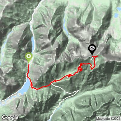
Mangart climbs out of Cave del Predil, a former mining hamlet in Italy's Tarvisio comune, and heads for the Italy-Slovenia border high in the Julian Alps. Over 16.5 km (10.2 mi) the route gains 1,175 m (3,856 ft) at a 6.8% average grade, starting at 848 m (2,782 ft) and topping out at 1,966 m (6,450 ft) on the Mangart road just below the Mangartsko sedlo saddle.
The first stretch follows the SS54 gently up to Passo del Predil (1,156 m), the historic pass between Mount Mangart and Mount Kanin that has linked Tarvisio with Bovec, Slovenia for centuries - a wide, easy grade past Lago del Predil. Just beyond the pass and the border, the road turns onto the dedicated Mangart branch, built by the Italian army in 1938, and the character of the ride changes completely: five tunnels blasted straight into the rock and a long series of hairpins carry the road up a steep, exposed mountainside with the Fusine Lakes visible far below on the Italian side.
As of the 2026 season, a rockslide has closed the upper Mangart road to all traffic beyond kilometer 9 of the direct Slovenian approach - including cyclists and pedestrians - with only a hiking trail continuing to the 2,055 m saddle from there; see our Vzpon na Mangart page for the closure and the alternate approach from Log pod Mangartom. Check current road status before planning to ride all the way to the top.
PLAN YOUR ROUTE
 We've partnered with Sherpa-Map.com to bring you the best route planning tool. With a PRO Membership you can use this climb as a reference when creating your route.
 From Cave del Predil to the top of this route, the climb covers 16.5 km (10.2 mi) with 1,175 m (3,856 ft) of total climbing at a 6.8% average grade - a figure that hides two very different halves.
The lower section, up and over Passo del Predil, is mild: the steepest 5 km (3.1 mi) anywhere on the climb averages 9.2%, and most of the early kilometers sit well under that. Past the pass, the dedicated Mangart branch is a different animal - the steepest kilometer averages 10.9%, and the steepest 100 m stretch spikes to 13.6% through the switchbacks below the tunnels. The final kilometers rarely relent, so save something for the second half.
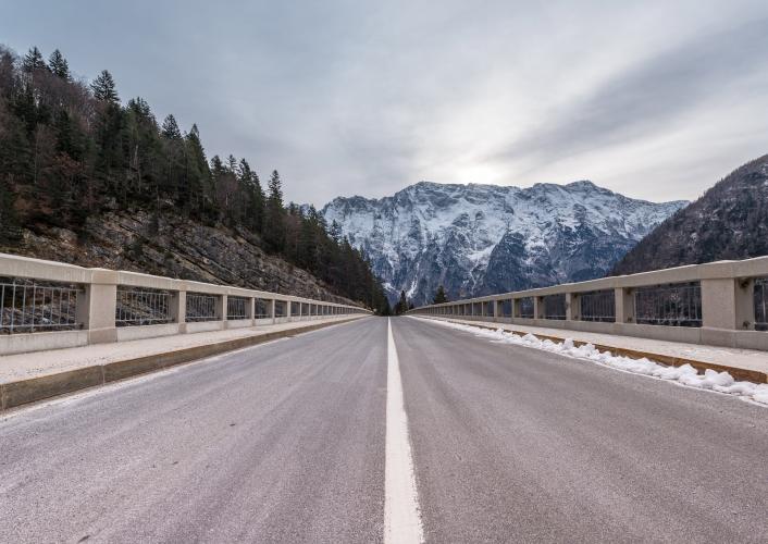
Roadway: The road is paved the entire way, from the SS54 through Cave del Predil and over Passo del Predil to the Mangart branch. Surface quality is good on the pass itself and through the lower tunnels, though the upper switchbacks - carved into the mountainside with five unlit tunnels - are narrower and rougher in spots; bring lights for the tunnels regardless of time of day. As of the 2026 season, a rockslide has closed the upper Mangart road to all traffic beyond kilometer 9 of the direct Slovenian approach, cyclists included - check current status on promet.si before planning to reach the saddle itself.
Traffic: Light on the Predil pass section, which carries local and cross-border traffic between Tarvisio and Bovec at a gentle grade. Traffic thins to nearly nothing on the Mangart branch itself, since it dead-ends at the saddle rather than connecting through - most vehicles there are visitors headed to the same viewpoint.
Parking: Cave del Predil, at the base, has roadside parking near the village center and the old mine entrance. There's also a small lot at the Passo del Predil summit itself if you'd rather start the steeper Mangart section fresh.
Bring a front and rear light regardless of the hour - the five tunnels on the upper Mangart branch are unlit and long enough to go fully dark inside, even at midday. Temperatures at 1,966 m (6,450 ft) run well below the valley floor even in summer, so pack a wind layer or vest for the descent. There are no services (water, food, or bike shops) past Cave del Predil, so fill bottles and eat before you start the climb.
Before heading out on any cycling adventure check out our Things to Bring on a Cycling Trip and use our interactive check list to ensure you don't forget anything.
Cave del Predil is a former Austro-Hungarian lead and zinc mining village, and its Polo Museale mining museum runs underground train tours through the old workings - a worthwhile stop before or after the ride if you have time.
The Fusine Lakes (Laghi di Fusine), a pair of glacial lakes with some of the best reflected views of the Julian Alps in Italy, sit a short drive north of the base and are a good add-on for a rest day. If you're basing out of Tarvisio itself, the short, brutally steep climb to the Santuario del Monte Lussari pilgrimage church is also nearby - see our Monte Lussari page for that one.
Ride between June and September - the Mangart branch is closed by snow outside that window, and even in summer the upper saddle can hold winter conditions. See other climbs in the Tarvisio area with our Routes in the Area tool if you're building out a multi-day trip through the Julian Alps.
ROUTE MAP
MEMBER RATING
CURRENT WEATHER
PJAMM TRIPS ADVENTURE STARTER BUNDLES
Check out PJAMM Adventure's prepackaged (self-guided) cycling trips. They will help you plan, document and conquer your next adventure.
NEARBY CLIMBS (0) RADIAL PROXIMITY
FROM No Climbs Found
MEMBER REVIEWS & COMMENTS
Let us know what you thought of this climb. Signup for our FREE membership to write a review or post a comment.
Already have an account?
LOG IN HERE
