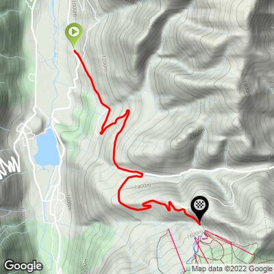
Peyragudes (2022 TDF) Bike Climb - PJAMM Cycling

5.3
FIETS
5 mi
DISTANCE
2,010 ft
GAINED
7.6 %
AVG. GRADE

FULL CLIMB STATS

Page Contributor(s): Carl Hansen, Guernsey, UK; Niamh Mooney, Pyrenees Cycling Lodge, Saint Savin, France

INTRO

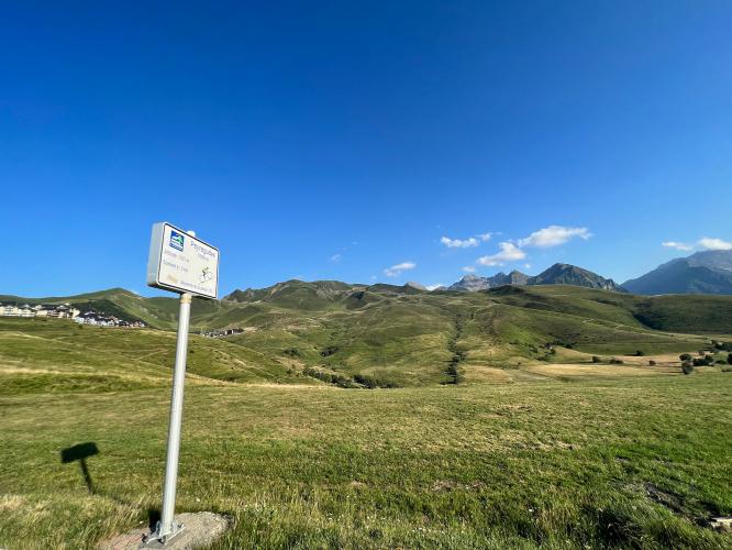
Shorter than our main route, Station de Peyragude.  Peyragudes is accessed via the Col de Peyresourde (D618). A right turn a couple of kilometers below the col from the western (Avajan) side takes you up to the ski station. The steepest parts of the listed climb are after turning off the D618 so it is worth the deviation from the Col de Peyresourde. 

See more details and tools regarding this climb's grade via our interactive Profile Tool.
Roadway: The roadway is in good shape all the way up to the ski station.

Traffic: There is moderate traffic in the summer on the D618. The road to the ski station has very little traffic.

Parking: You can park in Bagneres de Luchon, Arreau, Avajan and in some other places along the side of the road on both sides and the top of the Col de Peyresourde. You can also park at the Peyragudes ski station at the top of this climb.

Summer in the Pyrenees is normally warm and sunny, even at higher elevations. However, there are some periods of low clouds that can make the climbs quite damp. Bring warm clothes just in case. There are bike shops in Bagneres de Luchon and in St Lary Soulon. Water is available in Bagneres de Luchon, Arreau, and some of the smaller villages along the route.
Before heading out on any cycling adventure check out our Things to Bring on a Cycling Trip and use our interactive check list to ensure you don't forget anything.
This is the 2022 Tour de France Peyragudes route which takes a left at the roundabout at the ski resort and climbs another 800 meters at 4.2% to the high point of the road about 35 meters above the standard Station Peyragudes finish.

ROUTE MAP

MEMBER RATING

Not Yet Rated
-
Road
-
Traffic
-
Scenery

CURRENT WEATHER

PJAMM TRIPS ADVENTURE STARTER BUNDLES

Check out PJAMM Adventure's prepackaged (self-guided) cycling trips. They will help you plan, document and conquer your next adventure.
ALL TRIPS
Browse all of our prepackaged trips and find your next adventure!

NEARBY CLIMBS (0) RADIAL PROXIMITY

FROM
No Climbs Found

MEMBER REVIEWS & COMMENTS

Let us know what you thought of this climb. Signup for our FREE membership to write a review or post a comment.
Already have an account?
ROUTE MAP
PROFILE TOOL
Route Data
S.G. (%)
hide
Segment Data
hide

Climb Profile Not Found

Use of the Profile Tool requires a PJAMM Cycling PRO Membership!

It takes less than a minute to sign up & with your PRO membership you can:
  • Rate climbs, post comments and share your experiences on any of our climb pages
  • Create bucket lists of climbs & mark the dates you complete them
  • Weather data for all climbs - Start & Finish
  • Upload photos to your member page to customize your PJAMM Cycling experience
  • Utilize all of our interactive tools - Profile & Routes in Area
  • Download climb route .gpx files
Take a video tour:
LEARN MORE
SIGN UP

Already have an account? LOG IN HERE

CLIMB SUMMARY

sun shines down over Station Peyragudes ride, France, winding roadway in hills in distance

Cycling Station Peyragudes, France

Ride 9 kilometers gaining 674 meters at 7.5% average grade.

road signs at climb start, including one for Tour de France, Luchon, Peyragudes 

Climb start.

photo collage shows views along the climb, tree-lined roadway with mountains in distance

Peyragudes is accessed via the Col de Peyresourde (D618).  A right turn a couple of kilometers below the col from the western (Avajan) side takes you up to the ski station.  The steepest parts of the listed climb are after turning off the D618 so it is worth the deviation from the Col de Peyresourde.

road signs along the climb, green hillsides

The Tour de France has visited Peyragudes several times in recent years, mostly by first climbing the eastern (Bagneres de Luchon) side of the Col de Peyresourde.   The first stage finish in 2012 was in the upper village.  Recent stage finishes here – including in 2022 – have used the airport runway which gives a steep (15%+) run up to the finish.  Unfortunately, the runway is not available to most cyclists but the main road to the village still provides a good challenge!

Stage 17 of the 2022 Tour de France finishes at Station de Peyragudes.  Tour de France ride director C. Prudhomme says of Stage 17’s runway finish, in the final, even the best climbers might flounder when tackling the steep gradients towards the Peyragudes altiport... the third runway to success in the 2022 Tour!”

photo collage shows views along the climb including sun shining down on mountains, road signs for Peyragudes

There is also an upper road to Peyragudes very close to the top of the Col de Peyresourde on the western side.  It was used in the 2018 Tour de France on the way to the Col de Portet.  This road includes some climbing from either direction up to the Montee de Peyragudes, but it is best used to carry on through the village and join back up with the D618 (follow the route map, then continue on after the climbing stops).

photo collage shows sections of straight roadway, hairpin curves, ski lift