![Cycling Col de Tentes, France panoramic view of mountains: Cole de Tentes visible in center of photo]()
Cycling Col de Tentes, France
From the official start in Gavarnie:
Ride 10 kilometers, gaining 816 meters at 8.2% average grade.
The full climb to the finish of Col de Tentes begins at the crossroads of greatness: the ultimate starting point for this magnificent ride can also be used to climb Tourmalet and/or Luz Ardiden. The Argeles-Gazost/Luz-Saint Sauveur area is one of the greatest climbing zones in the world and is home to Tourmalet, Ardiden, Soulor, Aubisque, and several more.
The Tentes climb is in the Pyrenees mountain range of southwest Europe and forms the natural border between France and Spain. Along with the French Alps, the Pyrenees annually host the mountain stages of the Tour de France. The climb begins in Luz-Saint-Sauveur which is a commune in the French Hautes-Pyrenees department. The town has a population of 1,098 (1999) and is known by locals as “Luz” and its inhabitants are Luzeans. The incomparable Napoleon Bridge, completed in 1861 as a compliment to Napoleon Bonaparte who cherished the Pyrenees, is located at the southern edge of Luz-Saint-Sauveur over the Gave de Gavarnie Ou de Pau. .
![Cycling Col de Tentes, France speed limit sign entering Luz St. Gauveur]()
Full climb begins in Luz St. Sauveur (near start of Col du Tourmalet).
![Cycling Col de Tentes, France stone fountain in Gedre town center]()
Enter Gedre at km 6.3.
![Cycling Col de Tentes, France UNESCO World Heritage site, Gavarnie]()
The Col de Tentes-only climb begins just above the popular hiking destination of Gavarnie.
Gavarnie is a UNESCO World Heritage site.
![Cycling Col de Tentes, France cyclist street signs with views of the Pyrenees in distance]()
Climb begins a few hundred meters up the road from Gavarnie.
![Cycling Col de Tentes, France kilometer markers along climb route]()
There are kilometer markers each kilometer of the climb.
![Cycling Col de Tentes, France kilometer markers along the climb route]()
This climb rivals Stelvio for the most spectacular backdrops to Col or Tornate signs.
![Cycling Col de Tentes, France Ski Gavarnie-Gedre area; large rock formations]()
There are some absolutely stunning views on this climb - it is a Bucket List climb.
We ride through the small ski area of Station de Ski Gavarnie-Gedre half way up the climb.
![Cycling Col de Tentes, France tunnel; cyclist takes a dip in cool water pond along roadside]()
PJAMM founder and Sméagol doppelganger John Johnson takes a soak along the climb -
No shade but plenty of cool water in these mountains!
![Cycling Col de Tentes, France photo collage includes aerial drone view showing roadway's hairpin turns up mountainside; cattle grazing in pastureland]()
Much grazing land - cattle and sheep along the climb.
![Cycling Col de Tentes, France views along the climb include mountain views and pastureland, grazing sheep]()
![Cycling Col de Tentes, France sheep push against stone on roadside trying to find cool and shade during heatwave in summer 2022]()
Heat wave when we rode in July 2022.
Minimal shade on this climb but the sheep know where to find what little there was.
![]()
But, not so in the winters - this is a ski area, but oh, my - driving this road in snow . . . ??
Thanks to Niamh Mooney Pyreneese Cycling Lodge - PJAMM Preferred.
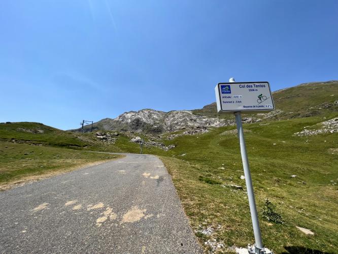
![Cycling Col de Tentes, France panoramic view shows Col de Tentes upper left of photo, roadway snaking up to finish]()
Col de Tentes upper left of photo
There is no col sign at the finish. 😞
![Cycling Col de Tentes, France PJAMM Cyclist John Johnson stands with bike at climb finish]()
Finish at the highway marker for D923.
The trail in the upper left and bottom right photos above is Les Lacs pres du Col des Especieres, which goes past the Spain/French border. The climb is located in Parc National des Pyrenees: created in 1967, covering 50,000 hectares (123,552 acres).
It does not appear that this climb has ever been included in the Tour de France. The road continues on as gravel for for 1.6 kilometers at 3.5% to Port de Boucharo. Wikipedia notes:
“The port of Boucharo has long been a crossing point in the Pyrenees. The idea of building a road is old. The construction of a road was thus planned by Napoleon in 1811. But it was not until the 1930s that studies were started in this direction. With the Spanish Civil War , then the Second World War , the project is set aside.
While in 1969 the road was completed on the French side, no road was ever built on the Spanish side. Finally the last 2 kilometers between the Col de Tentes and the port of Boucharo are downgraded. The tarred pavement is then removed to make way for a path accessible to people with reduced mobility in the first 800 meters” (Wikipedia).
Three other exceptional bicycle climbs begin near the start of Luz Ardiden.
![Station de Ski de Luz Ardiden]()
Luz Ardiden
![Station de Ski de Luz Ardiden]()
Col du Tourmalet
![]()
Cirque de Troumouse

 We've partnered with Sherpa-Map.com to bring you the best route planning tool. With a PRO Membership you can use this climb as a reference when creating your route.

