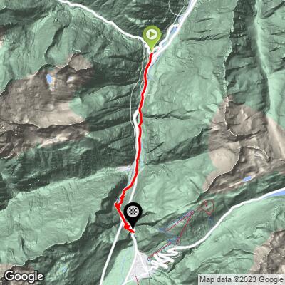
Cycling to the Devil’s Bridge from Wassen
Ride 8.7 kilometers gaining 490 meters at 5.6%
This is a route that starts on the N2 (the Gotthardstrasse, which runs in parallel to the A2 motorway) and ends at the iconic and historical Devil’s Bridge (or continuing to Oberalppass).
Climb summary by PJAMM Ambassador and uber cycling adventurer Helmuth Dekkers, of the Netherlands:
I started in Wassen so I could take on the Sustenpass also from the same town. From Wassen you follow the N2 towards Andermatt. Note the N2 when coming from Wassen, is not so busy trafficwise. After 2.3km (counted from the turnoff in Wassen to the Susten Pass) you will encounter a short tunnel which is 200m long and has a shoulder on the right side to cycle on. A little further down the road, 4 km from Wassen, you'll see a big, BIG stone with two flags on it on the left beside the road. This is the Devil's Stone (Teufelsstein), and is a large block of granite with a height of approximately 12 m and a mass of about 220 tons.

![]()
Devil’s Stone - Wikipedia
Sixty meters further we again face a tunnel. This one is 450 m long and you can cycle on both sides on a sidewalk, which is a bit higher than the road.

After 5.6 km you reach the first set of hairpin turns. To the right you can see a beautiful arched stone bridge, the Häderlis bridge (German: Häderlisbrücke), that crosses the river, and in front of you you’ll see the road twisting and turning, making its way upwards as it is cramped between the rock walls of the Schöllenen Gorge (German: Schöllenenschlucht). This gorge is formed by the Upper Reuss River and is very narrow. The way they have built the road here is impressive and so are the sheer rock walls enclosing it. After 6 km there is a gallery to protect the road against rocks falling down. It is 280 m long and there is no shoulder or sidewalk here that you can use. Then you’ll find a hairpin turn and again a long, 700 m, rockfall gallery. You then get four hairpin turns tightly squeezed in the little space the gorge offers here and then again we cycle into a 350 m long rockfall gallery that turns into a 50 meter-long tunnel at the end.

Tunnel just below Devil’s Bridge.
At the end of the tunnel, 8.5 km after we left Wassen, we reach the famous point in the Schöllenen Gorge where the so-called Devil's Bridge is located. It's a beautiful place where two bridges cross the Reuss River. One we use on this bike climb to reach the other side of the river ourselves. The other one is a bridge for pedestrians, and you can see it to the right of you a little lower than Devil’s Bridge.
The story goes that to build the Devil's Bridge the help of the devil was called for. The Devil agreed to help but with one condition: he would have the soul of the first to cross the bridge. When the bridge was finished, the villagers chased a goat over the bridge, meaning the Devil would have its soul and not one of theirs. Angered by this trickery, the Devil seized a huge boulder to smash the newly completed bridge. Before he could do so, however, he was stopped in his tracks by a holy man with a crucifix and fled, dropping the stone. And this is the Devil's Stone we passed on our way up.

The term Devil’s Bridge dates back to 1587.
Background bridge serves the Matterhorn Gotthard Railway; middle bridge is walking-cycling;
Foreground bridge is for vehicles (A-2).
Schöllenen Gorge is enclosed by sheer granite walls, its road and railway require several spectacular bridges and
tunnels, of which the most famous is a stone bridge known as the Teufelsbrücke ("Devil's Bridge").

Just after you cross the bridge there is a car park to the right side of the road, along with a small restaurant on the left side (Restaurant Teufelsbrücke). If you want to have a better view of the gorge and the two bridges spanning it, lock your bike here and go down to the right of the restaurant to the viewpoint. I suggest doing this on the way back.


The German name Teiffels Brucken (or Teufelsbrücke in modern German) means Devil’s Bridge.
Two hundred fifty meters after the Devil's Bridge we again face a tunnel and gallery of 400 m. A “gallery” in this instance is a half-open tunnel where the roof protects you from falling rock, but still allows you to look outside on the valley side. The amount of tunnels and rockfall galleries is of course due to the narrow gorge with steep rock walls where the road has little space, hence rockfall is a serious threat for damaging and blocking this important connection. Just after the tunnel/gallery you reach a roundabout and just follow the signs for Oberalppass, which is another 11.5 km of cycling.
Helmuth’s Words of Wisdom:
On this route there are many tunnels and galleries one has to cycle through. When cycling via the N2 (the first 10.6 km) you will encounter numerous tunnels and galleries! I didn't feel uncomfortable cycling through these, but I do recommend not to cycle that road during the weekend or holiday period as the traffic can be quite a bit busier, and definitely bring a tail and head light for safety. There are parts that are prohibited for cyclists but I did see many other cyclists on that road coming down and going up when I drove to my hotel. When I cycled the route myself, I was not the only cyclist. As long as you take precautions (lights) and avoid weekend and holiday periods you should be fine as I see it.
Tunnel Locations Along the Route:
When the turn to the Oberalppass has been taken in Andermatt (km 10.6), the traffic reduces substantially. At the end, along the lake and near the pass there is a very long gallery. It's a bit darker than normal galleries as there is a railroad between the road and the lake going through the same gallery. But it is well lit and there is some daylight too. And due to the very low amount of traffic, it is absolutely not a problem to cycle through with tail and headlights, of course.