
23.4
PDI
8 mi
DISTANCE
3,375 ft
GAINED
8 %
AVG. GRADE
FULL CLIMB STATS
INTRO
Obergummer is a 12.8 km (8.0 mi) climb from the Isarco valley floor at Prato all'Isarco (Blumau) to the high plateau hamlet of Obergummer (San Valentino di Sopra), part of the municipality of Cornedo all'Isarco (Karneid), gaining 1029 m (3,375 ft) at an 8.0% average. It shares its road with our Collepietra page - both follow the SP132 up the stack of hairpins to the village of Collepietra (Steinegg) - but this page is about where that road ends up: a quiet cluster of farms, chapels and meadows at about 1345 m (4,414 ft), facing the Catinaccio (Rosengarten) and Latemar massifs across the Val d'Ega.
The climb has a clear shape. The lower half is all about the hairpins, which lift you nearly 500 m in the first 5 km at a steady 9-10%. Above Collepietra the road straightens out and climbs through forest and open pasture at 7-9%, and the last kilometer or two ease off as the plateau opens up - just as the Dolomite skyline comes fully into view.
Obergummer is a working rural hamlet rather than a resort. Its landmarks are small: a pair of listed wayside chapels, a traditional inn, and, just nearby, the Max Valier observatory that helped earn this plateau its reputation as Europe's first star village - with almost no artificial light up here, the night sky is as much of a draw as the view.
PLAN YOUR ROUTE
 We've partnered with Sherpa-Map.com to bring you the best route planning tool. With a PRO Membership you can use this climb as a reference when creating your route.
 Obergummer climbs 12.8 km (8.0 mi) at an 8.0% average, gaining 1029 m (3,375 ft) from about 324 m (1,064 ft) in Prato all'Isarco to about 1345 m (4,414 ft) in Obergummer.
After a slightly gentler opening kilometer at about 7%, the hairpins take over: the 2nd kilometer is the steepest of the climb at about 10.6%, and kilometers 3 through 5 hold between 9% and 9.5%. Around Collepietra the grade dips to roughly 7-8% before a harder kilometer above the village at about 9.3%.
The upper third is steady rather than steep, averaging 7.4-7.9% per kilometer across the plateau, and the final 2 km ease to about 5% into Obergummer, so there's a chance to recover and enjoy the view on the way in.
The steepest half kilometer averages 11.1%, the steepest kilometer 10.5%, the steepest mile 10.0%, the steepest 2 km 9.8%, the steepest 5 km 9.4%, and the steepest 10 km 8.7%.
Roadway: Paved the whole way. The SP132 is a well-surfaced provincial road: tight and twisting through the hairpins below Collepietra, then wider and more direct across the plateau. It's a year-round access road for the villages above, so it stays open through the winter, but the upper half sits well above 1000 m and can carry snow and ice from late autumn into spring.
Traffic: Light for most of the climb - the SP132 mostly serves Collepietra, Obergummer and the farms around them. Expect a little more local traffic through Collepietra itself, and avoid the busy SS12 at the bottom if you're riding in from Bolzano; the paved Isarco valley cycle path is the safer approach.
Parking: Parking at the bottom in Prato all'Isarco is limited to on-street spots in the village (see our Collepietra page for the details on reaching the start by bike from Bolzano). If you're coming with non-riders or a camper van, the Untereggerhof inn in Gummer, on the plateau near the observatory, offers parking for campers and makes a natural meeting point at the top.
Gear: A compact crankset with a 30- or 32-tooth low cog suits this climb. The hairpins hold 9-10% for about 4 km without a break, and while the top third is easier, there's more than an hour of climbing for most riders. Standard road tires are fine.
Provisions: Stock up in Prato all'Isarco. Collepietra, about halfway, is the one village on the route with guesthouses and places to eat. At the top, the Gasthaus Untereggerhof, a traditional family-run inn a few steps from the Max Valier observatory, serves hearty South Tyrolean food daily from 8:00 to 20:00 except Wednesdays, its rest day - a good reason not to turn straight around.
Before heading out on any cycling adventure check out our Things to Bring on a Cycling Trip and use our interactive check list to ensure you don't forget anything.
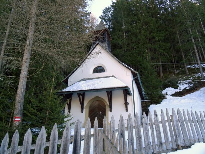
Obergummer's two listed chapels are the kind of detail you'd ride right past: the Holy Sepulchre chapel (Heilig-Grab-Kapelle) beside the Untersoler farm, and the Mount of Olives chapel (Ölbergkapelle) a little further along, both small white wayside chapels with shingled roofs, set among the meadows within about a kilometer of the finish.
From the Untereggerhof, the Planet Path (Planetenweg) walks you through a scale model of the solar system, from Mercury to Neptune, on the way to the Max Valier observatory - an easy post-ride stroll with the Catinaccio (Rosengarten) and Latemar towers as a backdrop. The observatory offers guided evening tours by reservation; the full story of the observatory, Collepietra's museum and castle ruins is on our Collepietra page, and Cornedo Castle on our Cornedo page.
From Obergummer you can drop down through Gummer toward the Val d'Ega, or string this climb together with Passo Nigra and Passo Costalunga - see other climbs nearby, or build a custom route from here, with our Routes in the Area tool.
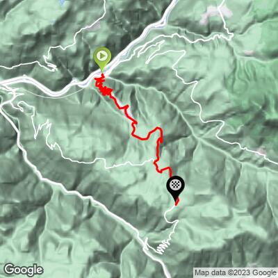
ROUTE MAP
MEMBER RATING
CURRENT WEATHER
PJAMM TRIPS ADVENTURE STARTER BUNDLES
Check out PJAMM Adventure's prepackaged (self-guided) cycling trips. They will help you plan, document and conquer your next adventure.
NEARBY CLIMBS (0) RADIAL PROXIMITY
FROM No Climbs Found
MEMBER REVIEWS & COMMENTS
Let us know what you thought of this climb. Signup for our FREE membership to write a review or post a comment.
Already have an account?
LOG IN HERE
