
23.6
PDI
15.5 mi
DISTANCE
4,468 ft
GAINED
5.4 %
AVG. GRADE
FULL CLIMB STATS
Page Contributor(s): Christine Desrochers, Sewell, New Jersey
INTRO
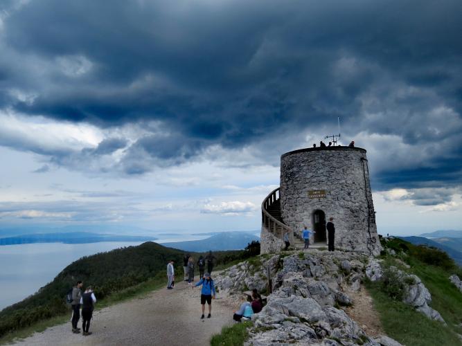
This is the longest way up Učka: 25.0 km (15.5 mi) from the edge of Rijeka, just above the Adriatic at 48 m (156 ft), to the Vojak lookout tower at 1387 m (4,549 ft), with 1362 m (4,468 ft) of climbing at a 5.4% average grade. Vojak, at 1401 m (4,596 ft), is the highest point of Učka and of the entire Istrian peninsula, and this route climbs to it by the old road over the mountain - via Matulji, the medieval hilltop village of Veprinac and the Poklon pass - rather than through the Učka Tunnel that carries today's motorway traffic underneath.
The climb comes in three distinct acts. The first 9 km (5.6 mi) are a gentle, suburban warm-up through Matulji and Bregi. From Veprinac the road turns serious, winding 9.5 km (5.9 mi) at 6.2% through chestnut and beech forest to Poklon (922 m / 3,025 ft), with the Kvarner Gulf opening up below. The finale is a narrow, single-lane road from Poklon to the summit, 5.6 km (3.5 mi) at 7.5%, and the final kilometer is the steepest of the day at 10.0%.
Poklon has always been a crossing point. For centuries, pilgrims from Istria walked over this pass to the shrine of Our Lady of Trsat in Rijeka, and bowed toward it once they reached the saddle - "poklon" means "bow." Today the road between Veprinac and Poklon is the course of the Trofej Učka, the Croatian national hill-climb championship, which held its 48th edition in June 2026 with finishes at Poklon or Vojak depending on category. It currently ranks #666 in the world on our list.
PLAN YOUR ROUTE
 We've partnered with Sherpa-Map.com to bring you the best route planning tool. With a PRO Membership you can use this climb as a reference when creating your route.
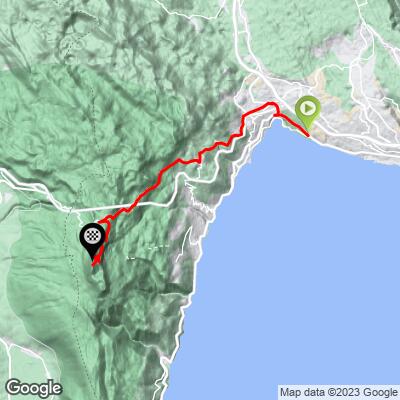
 Vojak from Rijeka climbs 25.0 km (15.5 mi) at an average grade of 5.4%, gaining 1362 m (4,468 ft) from 48 m (156 ft) on Ljubljanska cesta to a 1387 m (4,549 ft) finish beside the Vojak tower.
The first 9.0 km (5.6 mi), through Matulji and Bregi to the edge of Veprinac, average only about 3.5% and include a few near-flat stretches. From Veprinac to Poklon the road averages 6.2% for 9.5 km (5.9 mi), with the hardest stretch between km 14 and km 17 running at 7.7-8.4%. After a short breather over the Poklon saddle, the final 5.6 km (3.5 mi) to the summit average 7.5%, and the last kilometer is the steepest of the climb at 10.0%. The steepest mile averages 9.3%, the steepest 500 m 10.5%, and the steepest 100 yards 12.9%.
Roadway: Paved the entire way. The lower kilometers use urban streets through western Rijeka and Matulji, then county road Ž5047 - the old road over Učka - from Bregi through Veprinac to Poklon. Above Poklon, the Cesta za Vojak narrows to a single lane through beech forest to the summit. Construction of the new A8 motorway section between Matulji and the Učka Tunnel continues around Matulji into early 2027, so expect work zones and occasional detours near the start. The road above Poklon is closed by snow in winter, and the Učka Nature Park posts race-day closure notices for events like the Trofej Učka (June) and the CRO Race (September 2026) on its news page.
Traffic: Expect city traffic for the first 4 km (2.5 mi) through Kantrida and Matulji's town center. Ž5047 above Matulji is a quieter county road, busiest on weekends with locals heading up to Učka - and when the parallel motorway is closed for construction work, car traffic is detoured onto Ž5047 through Bregi and Veprinac, so check HAK traffic info before you go. Above Poklon, the upper road is largely closed to private cars, and you'll share it mostly with hikers.
Parking: The start is on a busy arterial road with no dedicated lot, so most riders simply roll out from their accommodation in Rijeka or Opatija. For a car-supported ride or a meeting point, Poklon has a car park and rest area next to the Učka Nature Park visitor center, 18.5 km (11.5 mi) into the climb.
Provisions: Matulji's town center at km 4 (2.5 mi) is the last easy place to grab supplies before the road gets serious. At Poklon (km 18.5 / mi 11.5), Restaurant Pansion Učka serves Istrian home cooking and game dishes on the pass itself, and the visitor center there has public toilets. Restaurant Dopolavoro is just past the saddle, near where the summit road begins. Beyond that, there's nothing but a small souvenir shop in the tower, so fill your bottles at Poklon.
Gear: The summit is nearly 1400 m (4,600 ft) above the start and can be windy and far cooler than the Opatija Riviera below, so bring a layer for the long descent. Compact gearing helps for the 10% final kilometer.
Before heading out on any cycling adventure check out our Things to Bring on a Cycling Trip and use our interactive check list to ensure you don't forget anything.
Veprinac, at km 10 (6.2 mi), is worth a stop on the way up or down. This walled hilltop village above Opatija is entered through a three-arched town gate, with a loggia on one side and the Chapel of St. Anne (with an inscription dated 1442) on the other, and the Church of St. Mark and its bell tower at the top. The village's own statute, the Veprinac Law, dates to 1507. Restaurant Aurora, just below the old village, has a terrace looking out over the Kvarner Gulf.
If you'd like to stay on the mountain, Pansion Učka at Poklon offers rooms right on the pass, a short ride from the Poklon Visitor Centre and the start of the summit road. At the top, the 1911 stone tower was fully renovated by the park in 2004 and now has an observation deck with telescopes. Učka's other paved sides, including Vojak West from inland Istria and the Ičići side from the coast, finish at the same summit - see other climbs nearby, or build a custom route from here, with our Routes in the Area tool.
ROUTE MAP
MEMBER RATING
CURRENT WEATHER
PJAMM TRIPS ADVENTURE STARTER BUNDLES
Check out PJAMM Adventure's prepackaged (self-guided) cycling trips. They will help you plan, document and conquer your next adventure.
NEARBY CLIMBS (0) RADIAL PROXIMITY
FROM No Climbs Found
MEMBER REVIEWS & COMMENTS
Let us know what you thought of this climb. Signup for our FREE membership to write a review or post a comment.
Already have an account?
LOG IN HERE
