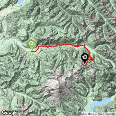
Mt. Baker Bike Climb - PJAMM Cycling

4.8
FIETS
24 mi
DISTANCE
4,726 ft
GAINED
3.3 %
AVG. GRADE

FULL CLIMB STATS

Page Contributor(s): Bruce Hamilton, La Quinta, CA; Stacy Topping, Tacoma, WA.

INTRO

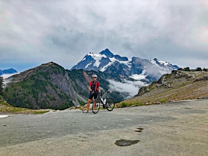
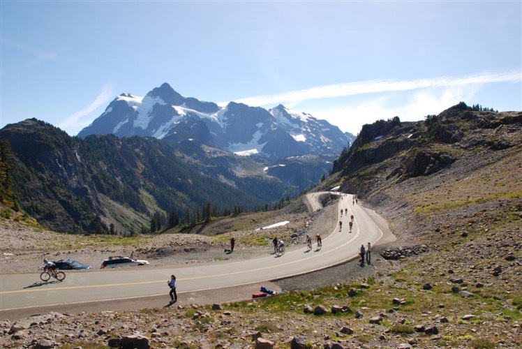
This scenic climb begins in Glacier, WA, which is the community closest to Mt. Baker, the northernmost mountain of the Cascade volcanoes, which stretch as far south as Lassen Peak in northern California and also include Mt. Shasta, Mt. Hood, and Mt. Rainier.

"One of the most isolated and scenic ascents in [the U.S.], Mount Baker is a long and spectacular climb close to the Canadian border in far northern Washington. Over a shallow grade within a drainage for the most part, scenery is king on this hill. Within the last few miles the grade increases as the route switchbacks in places up the mountain ridge. The parkway dead ends at Artist Point with incredible views of North Cascades National Park on clear days." (This quote is presented with the approval of John Summerson from The Complete Guide to Climbing (by Bike), 2nd Ed., p 225.)
Average grade is 3.3% (4.7% climb only).  21% of the ride is descent, 42% 0-5% grade, 34% 5-10% and 3% is at 10-15%. The steepest quarter-mile is 11.3% and steepest mile 7.4%.  

See more details and tools regarding this climb's grade via the “Profile Tool” button.
Roadway:  Good to Excellent.  Mt. Baker Highway Conditions - wsdot.com.

Traffic:  Light - the road dead ends at the top, thus no through traffic. 

Parking:  In Glacier, at or near climb start:  MapStreet View.
Provisions: None along the route or at the top. There is a store and bakery in Glacier at the beginning of the climb. 

Gear:  You can encounter challenging weather conditions on Mt. Baker.  Consult the PJAMM "Full Forecast" feature  for the time you expect to arrive at the finish to assess what clothing to bring on your ride.
Before heading out on any cycling adventure check out our Things to Bring on a Cycling Trip and use our interactive check list to ensure you don't forget anything.
Nearby Bellingham, Washington (35 miles from climb start) has many options for places to stay, including vacation rentals and hotels.

ROUTE MAP

MEMBER RATING

Difficulty: Challenging
3
Road
4
Traffic
5
Scenery

CURRENT WEATHER

PJAMM TRIPS ADVENTURE STARTER BUNDLES

Check out PJAMM Adventure's prepackaged (self-guided) cycling trips. They will help you plan, document and conquer your next adventure.
ALL TRIPS
Browse all of our prepackaged trips and find your next adventure!
Olympic NP: Hurricane Ridge
United States (WA), Canada
8 ROUTES
19 POIs
ROUTE STATS (TOTAL)
125
mi
DISTANCE
14,009
ft
ELEV. GAIN

NEARBY CLIMBS (0) RADIAL PROXIMITY

FROM
No Climbs Found

MEMBER REVIEWS & COMMENTS

Let us know what you thought of this climb. Signup for our FREE membership to write a review or post a comment.
Already have an account?

Sep 11, 2023
difficulty: Challenging
scenery: 5
traffic: 4
road: 3
Sep 11, 2023
scenery: 5
traffic: 4
road: 3
A beautiful climb from a really cool ski town.
ROUTE MAP
PROFILE TOOL
Route Data
S.G. (%)
hide
Segment Data
hide

Climb Profile Not Found
CLIMB SUMMARY

Cycling Mt. Baker

Ride 24 miles gaining 4,679’ at 3.3% average grade.  

Photo: Stacy Topping one mile up, 24 to go!

Mount Baker is located in the North Cascades of Washington State and offers cyclists a challenging and scenic ride up to the end of  Mount Baker Highway (State Route 542). The annual Mt. Baker Hill Climb takes place here on the fourth Saturday of September, starting in Glacier and covering a 24-mile ascent to scenic viewpoint Artist Point with views rivaling Glacier National Park.

Scenes along the first half of the climb.

This scenic northern Washington bike climb begins in Glacier, WA (population 211 in 2010) by riding east on Highway 542.  Glacier is the community closest to Mt. Baker, the northernmost mountain of the Cascade volcanoes, which stretch as far south as Lassen Peak in northern California and also include Mt. Shasta, Mt. Hood and Mt. Rainier.  Mt. Baker is  10,781’ and was first summitted by Edmund Coleman on August 17, 1868.

Climbing Mt. Baker by bike - view of Mt. Baker across the Salish Sea

Mount Baker as seen from the Salish Sea near Port Angeles, WA (on our Hurricane Ridge cycling trip).

While the average grade of the Mt. Baker climb is only 3.3%, the steepest mile begins at mile 1.4 (9%) and the steepest five mile stretch begins at mile 12.7 and continues almost to the top, averaging 6.2%.

Drone photo of Mt. Baker taken near the beginning of the climb.

Ride near or along the North Fork Nooksack River from miles 2-7

“The Mt. Baker-Snoqualmie National Forest is one of the most visited forests in the country. Located on the west side of the Cascades between the Canadian border and Mt. Rainier National Park, you will find glacier-covered peaks, spectacular mountain meadows and old-growth forests rich in history and outdoor opportunities.” fs.usda.gov

Scenes along the second half of the climb.

Mt. Baker Ski Resort and Raven’s Hut at ~mile 19

Before heading to Washington on your Mt. Baker cycling adventure, be sure to rely on our list of Things to Bring on a Cycling Trip, and use our interactive checklist to ensure you don't forget anything.

Bicycle climb Mt. Baker - pond near Chain Lakes Trailhead

Pond at the Chain Lakes Trailhead -- mile 22.

Fantastic scenery along the climb.

Mt. Baker in background top photo.

Mt. Shuksan is a prominent peak to the east as we climb

Mt. Shuksan is another scenic peak along our climb.  It can be mistaken for Mt. Baker, but just keep in mind that Shuksan is 2 peaks with minimal snow and Baker is one snow covered peak.  Also, Shuksan is east and Baker southwest as we climb.  Both are visible at the finish - Baker by walking just a bit up the paved trail at the finish of the climb.

Near the finish.

July 11, 2021

Finish

Biking Mt. Baker - Stacy Topping and Bruce Hamilton of PJAMM with bikes at Artist Point with  Mt. Shuksan in background

Climb ends at Artist Point -- Mt. Baker in the background (peak 10,781’’).

Southwestern view from Artist Point of Mt. Baker.

Thank you Bruce Hamilton and Stacy Topping!!

CHAIN  LAKES LOOP TRAIL

6.5 miles, 1,820’ elevation gain

An excellent way to see Mt. Baker from a hiking trail is Chain Lakes Loop Trail:

Chain Lakes Loop Trail is a 6.5 mile heavily trafficked loop trail located near Concrete, Washington that features a lake and is rated as moderate. The trail is primarily used for hiking, camping, and backpacking and is best used from June until October. Dogs are also able to use this trail but must be kept on leash.  AllTrails - Chain Lakes Loop Trail

The trailhead is at the finish of the climb, at Artists Point.

Access to full Climb Summary requires a PJAMM Cycling PRO Membership!

It takes less than a minute to sign up & with your PRO membership you can:
  • Rate climbs, post comments and share your experiences on any of our climb pages
  • Create bucket lists of climbs & mark the dates you complete them
  • Weather data for all climbs - Start & Finish
  • Upload photos to your member page to customize your PJAMM Cycling experience
  • Utilize all of our interactive tools - Profile & Routes in Area
  • Download climb route .gpx files
LEARN MORE
SIGN UP

Already have an account? LOG IN HERE