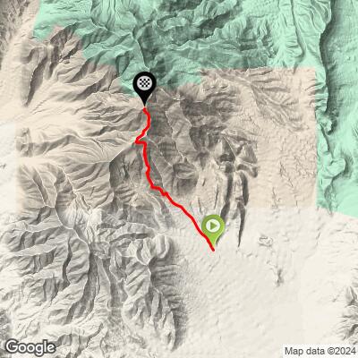
Potosi Mountain Bike Climb - PJAMM Cycling

48.6
PDI
4.3 mi
DISTANCE
3,513 ft
GAINED
15.9 %
AVG. GRADE

FULL CLIMB STATS

Page Contributor(s): Achille Beuret, Orleans, France

INTRO

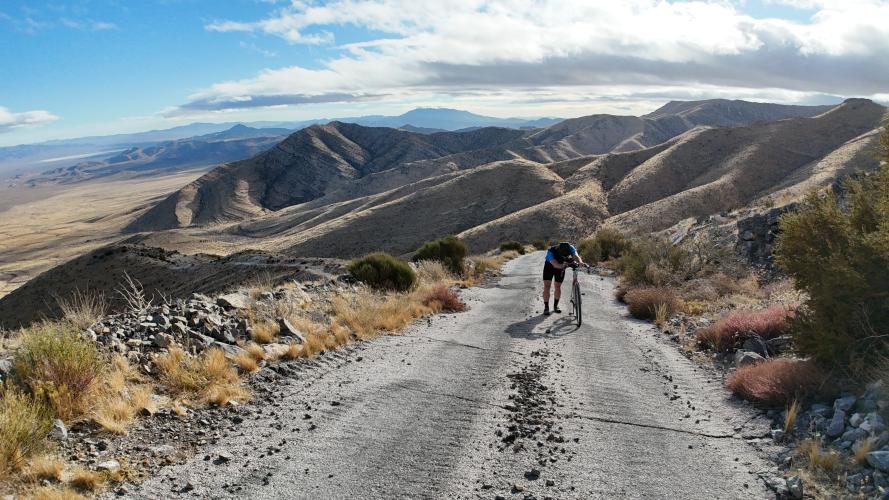
We have some choice words for this climb. Like, "why would you make a road like this?" And, "haven't you ever heard of a switchback?"

We've been all around the world looking for the steepest climbs, paved or gravel, and we've definitely found one here. This is the 47th steepest average gradient in the entire world regardless of length. Only including climbs 5km or longer, it's the 4th steepest road in the world. Attempt if you dare. 

PLAN YOUR ROUTE

We've partnered with Sherpa-Map.com to bring you the best route planning tool. With a PRO Membership you can use this climb as a reference when creating your route.

See more details and tools regarding this climb's grade via our interactive Profile Tool.
Surprisingly, much of this is paved. Most likely because parts are so steep that even a 4WD car couldn't get up it on loose rocks. We rode knobby gravel tires on low PSI to maximize grip, but all-roads will probably work just as well. Would I drive my grandma’s Camry up it? No, but I would drive her CRV up it. 

View the Images tab in our Profile Tool for more detailed information on the road surface.
No gear or provisions past the Terrible's/Chevron travel stop off the highway. 
Before heading out on any cycling adventure check out our Things to Bring on a Cycling Trip and use our interactive check list to ensure you don't forget anything.
Information Not Available

If you have any information regarding this climb, we'd like to hear from you. Click the CONTRIBUTE button to share your thoughts with us.

ROUTE MAP

MEMBER RATING

Not Yet Rated
-
Road
-
Traffic
-
Scenery

CURRENT WEATHER

PJAMM TRIPS ADVENTURE STARTER BUNDLES

Check out PJAMM Adventure's prepackaged (self-guided) cycling trips. They will help you plan, document and conquer your next adventure.
ALL TRIPS
Browse all of our prepackaged trips and find your next adventure!
Death Valley
United States (CA)
21 ROUTES
34 POIs
ROUTE STATS (TOTAL)
553.3
mi
DISTANCE
55,125
ft
ELEV. GAIN

NEARBY CLIMBS (0) RADIAL PROXIMITY

FROM
No Climbs Found

MEMBER REVIEWS & COMMENTS

Let us know what you thought of this climb. Signup for our FREE membership to write a review or post a comment.
Already have an account?

Dec 23, 2024
Would it be faster by just running uphills without a bike?
Dec 30, 2024
Hahaha. Yes. 100%
ROUTE MAP
PROFILE TOOL
Route Data
S.G. (%)
hide
Segment Data
hide
CLIMB SUMMARY

Potosi Mountain

One of the steepest roads we’ve ever encountered.

Ride Date:

November, 2024

What we rode:

Scott Addict

Our tires:

Front: 45mm knobby

Rear: 40mm knobby

What tires we recommend:

Hybrid/All terrain tires ok

View the Images tab in our Profile Tool for more detailed information on the road surface.


Climb summary by Sam Lyons (@sam.lionman)

This climb is ludicrous. Laughable. It took us a while to come here to document it because for a while, we just couldn’t believe that it was rideable. Unfortunately for us, it is. If you’re not familiar with what “Type 3 Fun” is, you’re about to find out.

What is “Type 3 Fun”, you ask? You can read Kelly Cordes’ iconic REI blog article on the Fun Scale, or we can let Google AI answer it for us:

“Riding your bike” might be a stretch. It got to be so ridiculous that I played a game: every time it was so steep I had to get off and walk, I hit the lap button so at the end of the workout, odd laps meant riding and even laps meant walking. Here’s the analysis:

Time Spent

Distance

% of total

Feet Climbed

% of total

Riding

0:57:43

2.94

69%

1,576

45%

Walking

1:24:45

1.32

31%

1,937

55%

Total Climb

2:22:28

4.26

3,513

Make of that as you will. It sure felt like I pushed my bike up most of this climb.

I documented this on the last day of a long weekend in Death Valley, rushing around to ride and document 11 remote gravel climbs in just 4 days. At this point after 3 full days of nonstop gravel riding, every part of my bike that does or doesn’t move is coated in dust and making a terrible noise.

It shouldn’t have been this bad. The gearing I’d brought for the trip was a very climbing friendly 1x with a 38T front and 46-10t rear SRAM cassette, but unfortunately I couldn’t use it here. Remember my little Wildrose incident two days before? That’s why:

Thankfully, I had brought an extra wheelset with me so I was able to continue the trip, but unfortunately that wheelset had a 36-10t cassette and was incompatible with the bigger one. So, I went into Potosi with worse than a 1:1 climbing ratio.

I ran my knobby gravel tires on a below usual PSI to help get the most amount of grip and traction when I inevitably have to stand up in the saddle. Much of this road is actually paved, because the sections are so steep a car on gravel would slide right back down. The much bigger factor here than the surface is the gradient.

Would I drive my grandma’s Camry up it? No, but I would drive her CRV up it.

Driving up to this thing you’re thinking, surely the profile can’t be right. But when you see it…

It’s right.

While most NORMAL roads would switch back like this... Potosi… does not.

Straight up.

At least it has the decency to give you a little bit of warm-up first…. A 9% warmup.

Past the gate, the rest of the climb averages 20%....

Oh good, it's paved up ahead…

I just saw a 47% grade….

This photo is taken with a level horizon. Don’t believe me? Look again:

The very bottom of the road is not even 3 miles away….

When you cross the ridge, you have 800 feet of climbing left to go. Here the surface gets really rocky:

After a couple short but very steep descents you begin the last push to the south summit. Turning left at the fork will take you to the main summit of Potosi Mountain - 2.5 more miles gaining 1,000 feet, but including 200 more feet of descent.

Part of this would be tough as a hiking trail alone….

Finally, if you reach the top, the views of downtown Las Vegas are superb - but not quite superb enough to make this whole darn ride worth it. This high in the mountains, the weather can change on a dime - dropped 15 degrees and started raining from when I started!

You might’ve walked, but you didn’t give up!

Potosi Mountain (main summit) in the distance.

Looking west towards Death Valley.

How long does it take you to ride 4.5 miles? 2.5 hrs too?

Was it worth it? I’m not sure.  But… I got a KOM!

Some segments have no attempts because nobody’s stupid enough to ride them….

There’s only one thing to do after conquering a climb like this… double fries 🍟🍟


Links:

Learn about PJAMM’s Surface Index

Learn about PDI (PJAMM Difficulty Index)