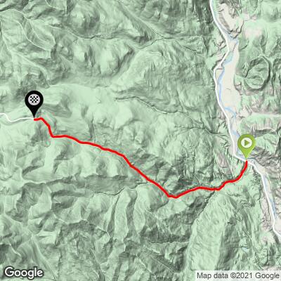
Boulder Creek Pass East Bike Climb - PJAMM Cycling

5.4
FIETS
11.7 mi
DISTANCE
3,237 ft
GAINED
5.1 %
AVG. GRADE

FULL CLIMB STATS

Page Contributor(s): William Meredith, Seattle, WA, USA

INTRO

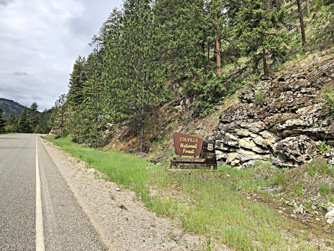
"The east side of Boulder Creek Pass is another fairly long and scenic northern Washington climb quite close to the Canadian border that essentially parallels Sherman Pass to its north. Carrying little traffic it is somewhat isolated and never particularly steep. The road does carry a solid grade most of the way up however and is through thick, northern hardwoods over most of its length. After a solid first mile the grade then eases back a bit for several miles. At that point you encounter the steepest sustained climbing on the hill and through a more twisty route. The slope then eases just a bit over the final half of the ascent. There is another slight grade decrease just before you reached the unmarked but obvious summit in a pleasant setting..." (Quoted from John Summerson's The Complete Guide to Climbing (by Bike), 2nd Ed., p 229.)
Average grade is 5.2% (5.7% climb only).  40% of the climb is at 0-5% grade and 46% at 5-10%.  The steepest quarter-mile is 11.3%, and steepest mile 7.7%.

See more details and tools regarding this climb's grade via the “Profile Tool” button.


Roadway:  Two lane roadway with center stripe in fair to good condition with a narrow shoulder most of the route.

Traffic:  Mild. 

Parking:  On Highway 395 at its junction with Boulder Creek Road (MapStreet View). 
Provisions:  The closest food and beverages are in Orient, 2.5 miles north (Map).
Before heading out on any cycling adventure check out our Things to Bring on a Cycling Trip and use our interactive check list to ensure you don't forget anything.
This is a fairly remote climb, but Sherman Pass is within striking distance 16 miles south (Map). 

Use the “Routes in Area” button on the menu bar to see other bike climbs in this area - filter for a bigger radius by clicking the "Routes in Area" button on the map. 

ROUTE MAP

MEMBER RATING

Difficulty: Challenging
5
Road
4
Traffic
3
Scenery

CURRENT WEATHER

PJAMM TRIPS ADVENTURE STARTER BUNDLES

Check out PJAMM Adventure's prepackaged (self-guided) cycling trips. They will help you plan, document and conquer your next adventure.
ALL TRIPS
Browse all of our prepackaged trips and find your next adventure!
Olympic NP: Hurricane Ridge
United States (WA), Canada
8 ROUTES
19 POIs
ROUTE STATS (TOTAL)
125
mi
DISTANCE
14,009
ft
ELEV. GAIN

NEARBY CLIMBS (0) RADIAL PROXIMITY

FROM
No Climbs Found

MEMBER REVIEWS & COMMENTS

Let us know what you thought of this climb. Signup for our FREE membership to write a review or post a comment.
Already have an account?

Nov 19, 2021
difficulty: Challenging
scenery: 3
traffic: 4
road: 5
Nov 19, 2021
scenery: 3
traffic: 4
road: 5
Nice climb, a pleasant grade with some twistyness to the road. Views are mostly of the surrounding timberland, so a bit repetitive after a few miles.
ROUTE MAP
PROFILE TOOL
Route Data
S.G. (%)
hide
Segment Data
hide

Climb Profile Not Found
CLIMB SUMMARY

Cycling Boulder Creek Pass

Ride 11.7 miles gaining 3,240’ at 5.2% average grade.

Climb summary by PJAMM’s William Meredith, Seattle, WA.

Starting 12 miles south of the Canadian border, US 395 makes a T with Boulder Creek Road against a backdrop of the Kettle River and a rolling hillside on the far bank. Kicking off about 15 miles north of the entrance to Sherman Pass via highway 20, Boulder Creek road is the quieter, more remote, route of the areas two passes. The road quickly leads into Colville National Forest, part of the larger Kettle Range of Eastern Washington – which is older than both the Cascade and Olympic ranges of Western Washington and was once higher before part of it shifted east, becoming the Huckleberry Range.

While the climb averages a 5.2% grade, its profile will show that the majority of the climb consists of sections that alternate between short legs of 7%-9% followed by short legs of 1%-3% grade. You might notice this the most in your breathing. Each time your breath and heart rate start to pick up on steeper road, it will be counter balanced by a few hundred flatter recovery yards. The result is a climb that never makes you work harder than you want to.

Slight rollers on the upper segment of the climb.

Boulder Creek road sticks to the north side of a valley which diverts water into the North Fork Boulder Creek, south of the road. Keep an eye on the hillside, to the right, while climbing. The Colville National Forest is home to a variety of large mammals including bighorn sheep, cougars, bears, and the last remaining heard of caribou in the lower 48.

Recently, forest fires have altered the scenery of the climb’s last 4 miles. Replacing the thick forest on each side, are rows and rows of black, skinny, trunks of burnt trees. Your line of sight extends now, past the trees to the crest of each hill and the sky behind it. The hillsides grow quiet as the upper reaches of the creek produce no noise. The wind that before moved against branches and needles, cuts quickly through the new landscape.  The fire has reset the ecosystem at the top of Boulder Creek Pass. Already, grasses have regrown and pyrophytic pine cones, activated in the blaze, are working to repopulate the summit.