
27.3
PDI
11.6 mi
DISTANCE
4,223 ft
GAINED
6.8 %
AVG. GRADE
FULL CLIMB STATS
Page Contributor(s): Graham Johnson, San Diego, CA; Matt Schubert, Escondido, CA
INTRO
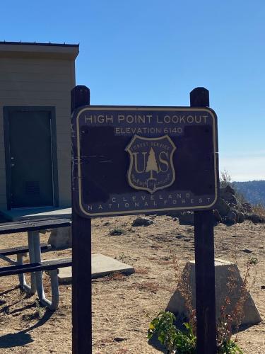
High Point Truck Trail is Palomar Mountain's lesser-known gravel ascent - an 11.55-mile, 4,223 ft climb up the mountain's rugged north side to the historic High Point fire lookout at 6,119 ft. Officially Forest Service Road 8S05, it's the rougher, more remote alternative to the popular Nate Harrison Grade on the mountain's south side, and a real step up in difficulty at an average grade of 6.8%.
Graham Johnson: This is the much lesser known, less steep dirt road up the north eastern side of Palomar. Our route for this climb includes Nate Harrison Grade. High Point is a bumpier, more rugged road than Nate Harrison.
Matt Schubert: Starts at the Aguanga Post Office/General Store between Temecula and Anza. Exposed, sandy and rutted in spots, a section called The Demoralizer on Strava that makes you wish for a mountain bike. First time I rode up, I found snow waiting above 4,000 feet. Mentally may be harder than Nate Harrison because you lose some elevation with descents on the way up.
The road climbs entirely within Cleveland National Forest's Palomar Ranger District, with almost no shade or water along the way. A National Forest Adventure Pass is required to park in the forest, and truck-trail conditions in this district change with fire danger and weather, so check current Cleveland National Forest alerts before you go.
PLAN YOUR ROUTE
 We've partnered with Sherpa-Map.com to bring you the best route planning tool. With a PRO Membership you can use this climb as a reference when creating your route.
 This climb starts on its steepest ground and eases from there. The first half-mile averages 11.3%, and the whole first mile holds above 10%, before the grade gradually relaxes toward the 6.8% overall average. There's no single brutal pitch - the steepest 100 yards on the route is 13.4% - so this is a climb defined by a sustained, punchy early effort rather than one make-or-break wall. See our interactive Profile Tool for the full gradient breakdown by segment.
Roadway: FSR 8S05 is a wide, non-technical but rugged forest road - exposed, sandy, and rutted in spots, with one notably rough stretch nicknamed "The Demoralizer" on Strava. It's packed enough for a gravel bike with wider, lightly knobby tires (around 35mm) in dry conditions, but it rides closer to true off-road than a manicured gravel path.
Traffic: Low. This is a Forest Service truck trail, not a public through-road, so traffic is limited to other recreational users - hikers, OHVs, and the occasional forest vehicle - rather than commuters. Watch for dust and blind spots on the switchbacks.
Parking: There's no dedicated trailhead lot. Riders typically start near the Aguanga Post Office/General Store on Highway 79, between Temecula and Anza. A National Forest Adventure Pass is required to park within Cleveland National Forest - display one on your dash if you're leaving a vehicle along the route.
Bring more water than you think you'll need - the climb is almost entirely exposed, with no shade and no reliable water sources between the highway and the summit. A gravel bike with wider, lightly knobby tires (around 35mm) handles the packed sections fine, but the sandy, rutted stretches (especially "The Demoralizer") reward extra tire volume and low gearing.
Conditions swing with elevation and season - riders have found snow above 4,000 ft even outside of true winter, so check recent conditions before heading up in the cooler months, and carry a light layer for the descent regardless of season.
Before heading out on any cycling adventure check out our Things to Bring on a Cycling Trip and use our interactive check list to ensure you don't forget anything.
Before heading out on any cycling adventure check out our Things to Bring on a Cycling Trip and use our interactive check list to ensure you don't forget anything.
Stage from Temecula or Anza, both roughly 20-30 minutes from the base on Highway 79 - Temecula has the fuller range of lodging, food, and bike shops if you need them beforehand. The Aguanga Post Office/General Store at the base is the last reliable stop before the climb.
Fire danger in the Palomar Ranger District runs high through the dry summer and fall months, and Cleveland National Forest's truck-trail and road closures change with conditions - check the Forest Service's current alerts for the Palomar Ranger District before you commit to a day here, and bring a National Forest Adventure Pass for parking.
Nate Harrison Grade, the more popular climb up Palomar's south side, is a natural pairing if you want to compare both approaches to the summit in one trip.
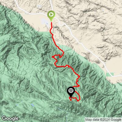
ROUTE MAP
MEMBER RATING
CURRENT WEATHER
PJAMM TRIPS ADVENTURE STARTER BUNDLES
Check out PJAMM Adventure's prepackaged (self-guided) cycling trips. They will help you plan, document and conquer your next adventure.
NEARBY CLIMBS (0) RADIAL PROXIMITY
FROM No Climbs Found
MEMBER REVIEWS & COMMENTS
Let us know what you thought of this climb. Signup for our FREE membership to write a review or post a comment.
Already have an account?
LOG IN HERE
