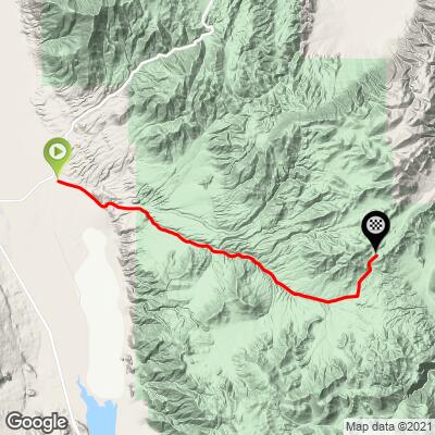
Death Valley Road (West) Bike Climb - PJAMM Cycling

7.2
FIETS
13.7 mi
DISTANCE
3,741 ft
GAINED
5.1 %
AVG. GRADE

FULL CLIMB STATS

Page Contributor(s): Ron Hawks, Las Vegas, NV, USA; Dan Razum, Campbell, CA, USA.

INTRO

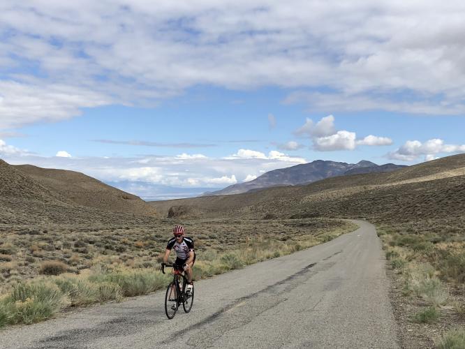
Cycling Death Valley - Death Valley Road West. There are no turns as we climb a very long, and potentially hot, 22 miles towards Death Valley.

See more details and tools regarding this climb's grade via our interactive Profile Tool.
 For road conditions see Inyo County Road Open/Closed Status.
Information Not Available

If you have any information regarding this climb, we'd like to hear from you. Click the CONTRIBUTE button to share your thoughts with us.

Before heading out on any cycling adventure check out our Things to Bring on a Cycling Trip and use our interactive check list to ensure you don't forget anything.
Hotels in Bishop

Owens Valley county road status: https://www.inyocounty.us/services/public-works/news/inyo-county-road-openclosed-status
Owens Valley State Highways and roads maintained by CDOT status : https://roads.dot.ca.gov/

ROUTE MAP

MEMBER RATING

Difficulty: Challenging
3
Road
5
Traffic
2
Scenery

CURRENT WEATHER

PJAMM TRIPS ADVENTURE STARTER BUNDLES

Check out PJAMM Adventure's prepackaged (self-guided) cycling trips. They will help you plan, document and conquer your next adventure.
ALL TRIPS
Browse all of our prepackaged trips and find your next adventure!
Death Valley
United States (CA)
21 ROUTES
34 POIs
ROUTE STATS (TOTAL)
553.3
mi
DISTANCE
55,125
ft
ELEV. GAIN
Owens Valley: Bishop
United States (CA)
19 ROUTES
26 POIs
ROUTE STATS (TOTAL)
268.3
mi
DISTANCE
55,531
ft
ELEV. GAIN
Owens Valley: Lone Pine
United States (CA)
15 ROUTES
31 POIs
ROUTE STATS (TOTAL)
157.7
mi
DISTANCE
51,016
ft
ELEV. GAIN

NEARBY CLIMBS (0) RADIAL PROXIMITY

FROM
No Climbs Found

MEMBER REVIEWS & COMMENTS

Let us know what you thought of this climb. Signup for our FREE membership to write a review or post a comment.
Already have an account?

Apr 16, 2021
difficulty: Challenging
scenery: 2
traffic: 5
road: 3
Apr 16, 2021
scenery: 2
traffic: 5
road: 3
This is a good climb to do when the weather is not good on the other side of the valley. Bring along everything you might need because there are few signs of civilization on the climb. I saw fewer than 5 cars total on the climb and descent after turning off 168. You can park at the intersection of 395 and 168 (or in Big Pine).
ROUTE MAP
PROFILE TOOL
Route Data
S.G. (%)
hide
Segment Data
hide

Climb Profile Not Found
CLIMB SUMMARY

Cycling Death Valley Road - a Top 100 US Bike Climb in a very hot venue.

Cycling Death Valley - PJAMM’s list of Top Death Valley bike climbs.

Turn right off Hwy 168 out of Big Pine to get started.


Bishop is the closest weather station and it is accurate for this location.

Climb summary by PJAMM friend and contributor Dan Razum, Campbel, CA.  

The climb starts at the intersection with Hwy 168, a couple of miles from Hwy 395.  We climb up the eastern

side of Owens Valley, while the Eastern Sierra mountains loom on the western side of Owens Valley.


Eastern side of the Sierra Nevada Mountains - part of Glacier Lodge Road can be seen.


We enter Inyo National Forest at mile 3.

Tough to see the forest from the lack of tree 😃

The climb has a steady gradient the entire way, never too steep, with long straight stretches of road, which make for a

fun descent. The scenery is fairly steady the entire way as well, high desert with sage brush and small plants.


Looking back at the road we climbed, Eastern Sierras in the background.

Finish - the top of the climb is unmarked, but it is fairly easy to see where the road peaks.

This is a remote climb without any services or water along the way, so plan accordingly.  The temperatures can

get hot and once the sun clears the hills, there is no shade anywhere. There are some cracks in the pavement

but overall the road is in decent condition.  There is no shoulder along the road, but traffic is very light,

so it's not a problem.

Access to full Climb Summary requires a PJAMM Cycling PRO Membership!

It takes less than a minute to sign up & with your PRO membership you can:
  • Rate climbs, post comments and share your experiences on any of our climb pages
  • Create bucket lists of climbs & mark the dates you complete them
  • Weather data for all climbs - Start & Finish
  • Upload photos to your member page to customize your PJAMM Cycling experience
  • Utilize all of our interactive tools - Profile & Routes in Area
  • Download climb route .gpx files
LEARN MORE
SIGN UP

Already have an account? LOG IN HERE