![Cycling Mt. Ashland, Oregon via Loop Road: narrow gravel road approaching the summit of Mt. Ashland, National Weather Service dome in distance]()
Cycling Mt. Ashland via Loop Road
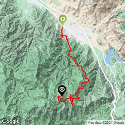
Ride 20.7 miles gaining 5,819’ at 5.1% average grade (7.1% climb only).
The Loop Road route — leading to the weather dome at Mt. Ashland’s 7,532’ summit — is one of three Top 100 US Gravel Climbs. Not only is it one of the hardest US climbs, it is also one of the jewels of Oregon gravel cycle climbs.
![Cycling Mt. Ashland, Oregon via Loop Road: Photo collage shows PJAMM Cyclist riding gravel ascent up to summit of Mt. Ashland, bike parked next to sign reading "Welcome to Mt. Ashland," Aerial drone view of National Weather Service's dome at mountain summit, and road sign for Ashland Loop Road]()
The paved route to Mt. Ashland ends at the Ashland Ski Resort, while the three gravel routes continue past the parking lot for 2.5 miles at 6.8%, ending at the summit of Mt. Ashland and the National Weather Service radar dome.
Climb Summary by PJAMM Cycling’s Brad Butterfield:
This is an absolutely remarkable gem of a climb that starts adjacent to Main Street in downtown Ashland, Oregon. Beginning at the idyllic Lithia Park, the dirt road goes through a residential area first, then through a network of downhill mountain biking trails. There is sure to be a number of cars and trucks hauling mountain bikes up this first section of the mountain, when the weather permits.
![Cycling Mt. Ashland, Oregon via Loop Road: photo collage shows lush green and floral scenes at Lithia Park, Ashland Oregon; PJAMM bike and jersey parked next to white Lithia Park sign; pink rhododendrons]()
![Cycling Mt. Ashland, Oregon via Loop Road: photo collage shows views of Ashland Loop Road, lush green roadway, bold bridge, garmin device]()
Climb is paved until turning onto Ashland Loop Road at mile 1.8.
As you climb, the vegetation shifts dramatically — from deciduous trees at the beginning of the climb, to Duglas Fir and Ponderosa Pine for the majority of the climb.
![Cycling Mt. Ashland, Oregon via Loop Road: photo collage shows aerial drone views of thick forestation covering most of the climb]()
Thick forest for most of the climb.
On the day I rode, I was passed by at least 20 cars and trucks with mountain bikes. Once beyond the first third of the climb, I didn’t see anybody. Just me, a pristine dirt road, and incredible views to enjoy. From there, the real climb begins. There are long stretches of double-digit gradients, especially in the opening half of the climb, however the hard pack, smooth gravel allows for riders to stand up and pedal through the steep grades without losing traction.
![Cycling Mt. Ashland, Oregon via Loop Road: photo collagre shows intersection of Terrace Street and Ashland Loop Trail, where road changes from paved to gravel]()
Road turns to gravel for the next 14 miles at 4.5% at mile 1.8.
![Cycling Mt. Ashland, Oregon via Loop Road: photo collage shows narrow, gravel roadway with road signs reading "End of City Maintenance," and "Creek to Crest Trail Route"]()
City stops maintaining Loop Road at about the one-mile mark.
![Cycling Mt. Ashland, Oregon via Loop Road: bike parked in front of yellow gate, blocking gravel roadway off to car traffic]()
Vehicle gate at mile 3.7; no problem to ride around.
![Cycling Mt. Ashland, Oregon via Loop Road: photo collage shows informational signs on Four Corners Trailhead, including maps and general trail reminders, bike with PJAMM Cycling jersey draped over it parked in front of signage]()
Four Corners Trailhead at mile 6.5.
![Cycling Mt. Ashland, Oregon via Loop Road: photo collage shows PJAMM Cyclist riding on well-maintained, smooth gravel roadway lined with pine trees]()
The gravel on Loop Road is smooth and well-maintained.
This unpaved road is in far better condition than many paved roads across the globe — it is truly impressive how well this off-road route is maintained. Mt. Ashalnd is a cyclist's dream! With around six miles to go, the gravel road intersects with the paved route up Mt. Ashland.
![Cycling Mt. Ashland, Oregon via Loop Road: photo collage shows the merge onto the paved Mt. Ashland Road at Bull Gap, mile 16 of bike climb; snow dots the mountain in the distance, where National Weather Service Dome can be seen on mountain summit]()
Merge onto paved Mt. Ashland Road at mile 16 at Bull Gap.
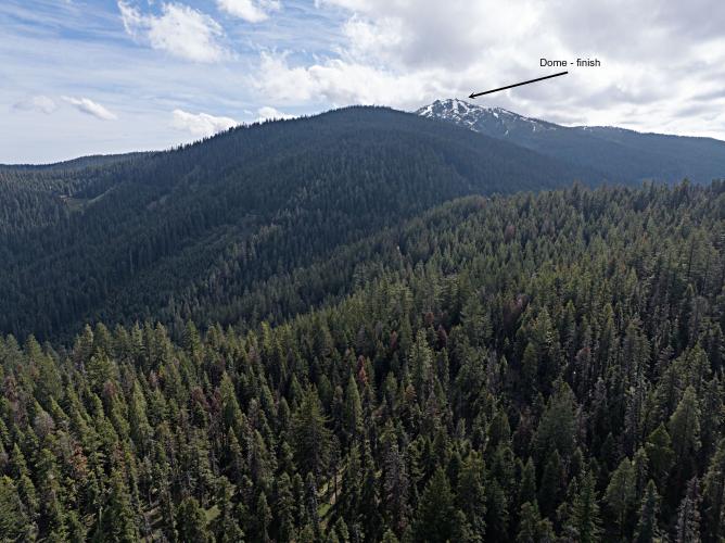
![Cycling Mt. Ashland, Oregon via Loop Road: panoramic, sweeping view of dense pine tree forestation covering mountains, in the far distance the National Weather Service dome can barely be seen atop Mt. Ashland, climb's finish]()
Our destination is the summit of Mt. Ashland and the National Weather Service radar dome.
Our destination, the NWS weather dome is in site as we climb the paved section to the ski resort. After merging onto Mt. Ashland Road at mile 16, we ride on pavement for 2.1 miles at 4.3% to just past the ski resort parking lot. Along this segment there are some very distant views of Mt. Ashland. It is quite an imposing sight and a daunting pill to swallow to pedal ALL the way up there, after already climbing for 16 miles.
![Cycling Mt. Ashland, Oregon via Loop Road: photo collage shows parking lot and ticket booth for Mt. Ashland Ski Area]()
The parking lot and ticket booth for Mt. Ashland Ski Area is at mile 17.9.
Mt. Ashland Ski Area opened in 1964.
The bottom photo in the above collage is of Mt. Shasta, which is the most visible Mountain in California, standing alone and at over 14,000’. Mt. Shasta is visible from over 100 miles, although the distance from this point of view is 53 miles. The ski lodge marks the end of the pavement, then it is dirt to the summit.
![Cycling Mt. Ashland, Oregon via Loop Road: bike parked in front of green gate, closing gravel roadway off to vehicle traffic at ski resort parking lot]()
Pass the gravel gate at the end of the ski resort parking lot and ride 2.5 miles at 6.7% to the top of the mountain.
![Cycling Mt. Ashland, Oregon via Loop Road: snow-capped views of Mt. Shasta (California) in the distance; bike parked in front of National Parks Service yellow and brown sign reading "Mount Ashland Campground Klamath National Park"]()
Views of Mt. Shasta, CA, 52 miles to the southeast as we climb.
![Cycling Mt. Ashland, Oregon via Loop Road: photo collage shows hoodoo rock formations near the top of the Mt. Ashland ride, gravel roadways, pine forestation]()
Hoodoo formation near the top.
We run parallel to the Pacific Crest Trail (to our left) for a mile beginning at mile 18.1.
![Cycling Mt. Ashland, Oregon via Loop Road: aerial drone view shows one final hairpin turn before the last leg to the top, green pine trees and stark white snow on mountain]()
Final hairpin before the push to the top.
![Cycling Mt. Ashland, Oregon via Loop Road: narrow, one-lane gravel roadway with white National Weather Service dome in background, sign reads "Day Use Only" and "No Fires"]()
The final mile of the climb is steep, averaging ~10%, with loose gravel and extremely difficult to ride, especially at 7,000+ feet of elevation. When I did this climb on June 3, 2024, there were several snow-covered sections near the top and the winds were howling with temperatures were near freezing. The views, of course, were unbeatable at the summit.
![Cycling Mt. Ashland, Oregon via Loop Road: aerial drone views of white National Weather Service weather dome sitting atop Mt. Ashland from climb's summit, green pine forestation and white snow patches on mountaintop]()
Most bike climbs do not make it all the way to the summit of the mountain climbed, but this amazing climb does. We finish at the summit of Mt. Ashland and the NWS weather dome which first became operational in 1996, and tracks weather patterns for Southern Oregon and Northern California.
![Cycling Mt. Ashland, Oregon via Loop Road: photo collage shows aerial drone views of deep volcanic ash, large white, round, National Weather Service dome, and bike parked in snow patch on mountain's top]()
The deep volcanic ash and spectacular views at the summit.
Mt. Ashand offers everything a cyclist could want in a gravel adventure!