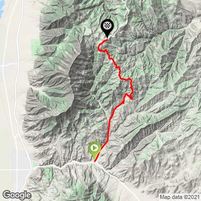
21.8
PDI
13.8 mi
DISTANCE
3,860 ft
GAINED
4.9 %
AVG. GRADE
FULL CLIMB STATS
Page Contributor(s): Bruce Hamilton and Stacy Topping, Midway, UT
INTRO
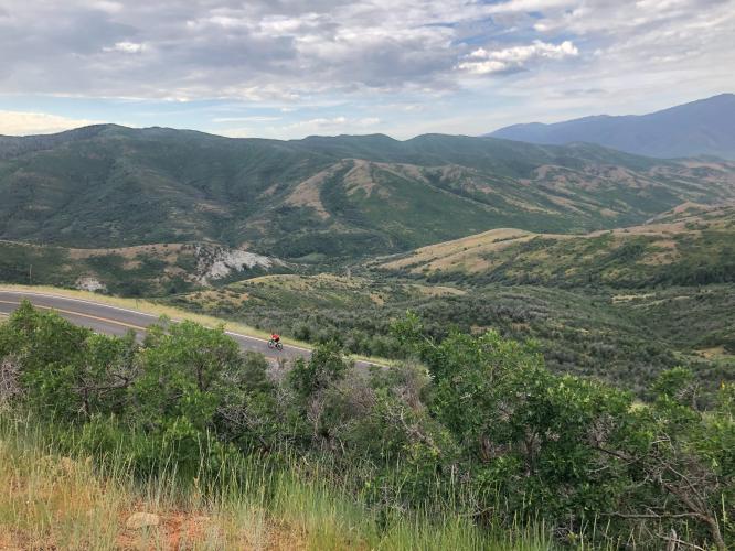
The Nebo Loop North climb begins at the southern edge of Payson, Utah about 60 miles south of Salt Lake City. Payson was established in 1850 and named by Brigham Young himself. This is a peaceful climb along a US Scenic Byway.
"Used in the difficult Tour of Utah, the south side of Nebo Loop Road is a solid and scenic climb up the massive slopes of Mount Nebo in central Utah. Shallow to start, the grade soon picks up as the road begins to switchback up the hill. Excellent views are present back down to climb start in places. Just over 5 miles into the ascent is a big turn to the right with increased grade for a stretch and views..." (This quote is presented with the approval of John Summerson, from his book, 50 Climbs (by Bike) in Utah, pg. 118.)
PLAN YOUR ROUTE
Average grade is 4.8% (6.1% climb only). The gradient swing on this climb is substantial - 14% is descent, 34% is at 0-5% grade, 42% is at 5-10%, 10% is at 10-15%, and a small fraction is at 15-20%. The steepest quarter-mile is 11.1% and steepest mile 9.4%.
See more details and tools regarding this climb's grade via the “Profile Tool” button.
Roadway: This is a two lane paved Forest Road 015 that is in fair to rough shape.
Traffic: Mild.
Parking: Up the climb about 7/10ths of a mile on the right side of the road (Map; Street View).
Provisions: None on the climb - closest food and beverages are in Nephi, five miles west (Map).
Before heading out on any cycling adventure check out our Things to Bring on a Cycling Trip and use our interactive check list to ensure you don't forget anything.
Consider this climb with Nebo Loop Road North - 64 miles gaining 9,340' (Map).
Use the “Routes in Area” button on the menu bar to see other bike climbs in this area.
ROUTE MAP
MEMBER RATING
CURRENT WEATHER
PJAMM TRIPS ADVENTURE STARTER BUNDLES
Check out PJAMM Adventure's prepackaged (self-guided) cycling trips. They will help you plan, document and conquer your next adventure.
NEARBY CLIMBS (0) RADIAL PROXIMITY
FROM No Climbs Found
MEMBER REVIEWS & COMMENTS
Let us know what you thought of this climb. Signup for our FREE membership to write a review or post a comment.
Already have an account?
LOG IN HERE