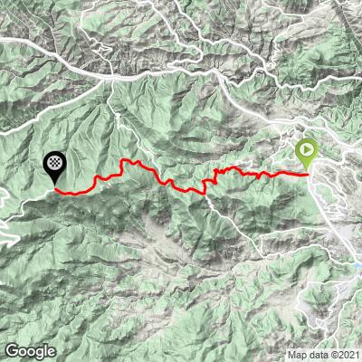
Juniper Pass East Bike Climb - PJAMM Cycling

6.8
FIETS
14.8 mi
DISTANCE
3,473 ft
GAINED
4.3 %
AVG. GRADE

FULL CLIMB STATS

Page Contributor(s): Christopher Jacobs, Byers, CO, USA; Steve Jones, Olympia, WA, USA

INTRO

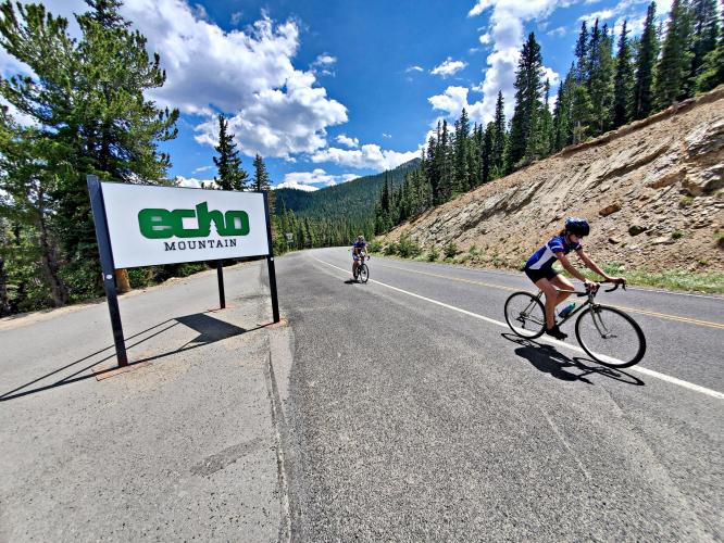
"Another moderate grade and high altitude climb, the east side of Juniper Pass is very scenic in places. You may find more bikes on this road than autos on many days which is a nice change.  The grade is steady and through thick woods almost all the way up and never steep," (This quote provided with approval from John Summerson from his book, The Complete Guide to Climbing (by Bike) in Colorado pg. 102.). 
4.3% average grade (4.7% climb only). 48% of the climb is at 0-5% grade and 45% is at 5-10%.  The steepest quarter-mile is 7.9% and steepest mile 6.3%.

See more details and tools regarding this climb's grade via the “Profile Tool” button.
Roadway:  Two lane highway in good condition with a narrow shoulder much of the climb. 

Traffic:  Mild. 

Parking:  At the park across the highway from the start of the climb - MapStreet View
Provisions:  None on the climb but plenty in Bergen Park where the climb begins. 

Weather and Gear:  We travel to 11,000 (33% less oxygen there than at sea level - we lose 3% every 1,000') - so be sure to consult the PJAMM "Full Forecast" feature for the time you expect to arrive at the finish to assess what clothing to bring on your ride.
Before heading out on any cycling adventure check out our Things to Bring on a Cycling Trip and use our interactive check list to ensure you don't forget anything.
Doing Juniper Pass East with Juniper Pass West is a nice out and back - 62 miles gaining 7,210' (Map).  Or, add the last 14 miles of Mount Evans - the turn off to Mt. Evans Road is just 2.3 miles down the road from Juniper Pass and the first 13 miles of Mount Evans and Juniper Pass West overlap.  Mount Evans is the highest paved road in North America. 

ROUTE MAP

MEMBER RATING

Not Yet Rated
-
Road
-
Traffic
-
Scenery

CURRENT WEATHER

PJAMM TRIPS ADVENTURE STARTER BUNDLES

Check out PJAMM Adventure's prepackaged (self-guided) cycling trips. They will help you plan, document and conquer your next adventure.
ALL TRIPS
Browse all of our prepackaged trips and find your next adventure!
Colorado: Front Range
United States (CO)
20 ROUTES
46 POIs
ROUTE STATS (TOTAL)
563.5
mi
DISTANCE
73,545
ft
ELEV. GAIN
RMNP: Trail Ridge Road
United States (CO)
13 ROUTES
33 POIs
ROUTE STATS (TOTAL)
258.2
mi
DISTANCE
25,530
ft
ELEV. GAIN

NEARBY CLIMBS (0) RADIAL PROXIMITY

FROM
No Climbs Found

MEMBER REVIEWS & COMMENTS

Let us know what you thought of this climb. Signup for our FREE membership to write a review or post a comment.
Already have an account?
ROUTE MAP
PROFILE TOOL
Route Data
S.G. (%)
hide
Segment Data
hide

Climb Profile Not Found
CLIMB SUMMARY

Cycling Juniper Pass East, Colorado - view looking town a straightaway on a two-lane paved road along mountainside, dense forestation and blue sky

Cycling Juniper Pass East

Ride 14.8 miles gaining 3,423’ at 4.3% average grade.

Both sides of the Juniper Pass climb are entirely within Colorado’s Arapaho and Roosevelt National Forests which are jointly managed by the National Forest Service. Arapaho National Forest, established in 1908 by President Theodore Roosevelt and named for the Arapaho Native American tribe consists of 723,000 acres, and Roosevelt National Forest, established in 1902 by President Roosevelt (originally named Medicine Bow Forest Reserve and renamed to honor President Theodore Roosevelt in 1932) consists of 813,000 acres.

Cycling Juniper Pass East, Colorado -  photo collage, PJAMM Cycling logo in corner, roadsigns for Colorado Highway 103 and Interstate 70, cyclist standing in front of bike next to sign for Arapaho National Forest picnic ground, views down mountainside showing dense evergreen forestation and patches of grey rock

The Juniper Pass East bike climb begins at the intersection of Highway 74 and Squaw Pass Road (Highway 66) by riding west and up Highway 66. We ride past Squaw Pass at mile 8.6 and bend left onto Highway 103 at this point and ride another six miles to our destination.  Overall, we ride 14.8 miles to elevation 11,156’ gaining 3,631’ at a 4.3% average grade from the east side of Juniper Pass.

Cycling Juniper Pass East, Colorado - sign for Arapaho National Forest and Juniper Pass

Ride report from PJAMM Cycling’s Steve Jones, Olympia, WA:

The east side of Juniper Pass begins in Bergen Park, CO (7,822 ft.) at the junction of State Routes 74 (Bergen Parkway) and 103 (Squaw Pass Road).  The ride traverses Squaw Pass (9,807 ft.) and reaches the unsigned high point (11,130 ft.) after 15.9 miles. The grade is moderate and the pavement smooth. 2.7 miles past Juniper Pass is Echo Lake (10,597 ft.) and the turn to Mt. Evans (14,260 ft.).  The Juniper Pass ride is an alternative starting point to Idaho Springs for those cyclists headed for Mt. Evans.

Cycling Juniper Pass East, Colorado  - photo collage, PJAMM Cycling logo in corner, Welcome sign for Mt. Evans, North America's Highest Auto road, reflection in Echo Lake of mountains, clouds, evergreens, road sign for Bergen Park and Mt. Evans

Turn off to Mt. Evans, 2.7 miles past our summit. 

Cycling Juniper Pass East, Colorado - selfie of cyclist wearing PJAMM Cycling jersey along roadside at high point between Squaw Pass and Echo Lake

Juniper Pass (11,130’) is an unsigned high point

located between Squaw Pass and Echo Lake, near Mt. Evans.

Thank you Steve!

Access to full Climb Summary requires a PJAMM Cycling PRO Membership!

It takes less than a minute to sign up & with your PRO membership you can:
  • Rate climbs, post comments and share your experiences on any of our climb pages
  • Create bucket lists of climbs & mark the dates you complete them
  • Weather data for all climbs - Start & Finish
  • Upload photos to your member page to customize your PJAMM Cycling experience
  • Utilize all of our interactive tools - Profile & Routes in Area
  • Download climb route .gpx files
LEARN MORE
SIGN UP

Already have an account? LOG IN HERE