
11.3
PDI
3 mi
DISTANCE
1,474 ft
GAINED
9.4 %
AVG. GRADE
FULL CLIMB STATS
Page Contributor(s): John Summerson, Winston-Salem, NC, USA (The Complete Guide to Climbing (by bike)
INTRO
“Whitcomb Hill Road is a steady and solid grade ascent away from the scenic Deerfield River toward Route 2 in western Massachusetts. Good scenery and a wide and lightly travelled road make for a pleasant ascent as long as the stout (but mostly steady) grade does not deter. There are also a few switchbacks along the way to spice things up. At mile 2.5 turn right on busier Route 2 to finish over more moderate grade at the obvious summit. Due to grade Whitcomb Hill Road is also a quick and somewhat challenging descent.” (This quote is provided with the approval of John Summerson from his book, The Complete Guide to Climbing (by Bike) in the Northeast, pg. 73.)
PLAN YOUR ROUTE
See more details and tools regarding this climb's grade via our interactive Profile Tool.
Information Not Available
If you have any information regarding this climb, we'd like to hear from you. Click the CONTRIBUTE button to share your thoughts with us.
Information Not Available
If you have any information regarding this climb, we'd like to hear from you. Click the CONTRIBUTE button to share your thoughts with us.
Before heading out on any cycling adventure check out our Things to Bring on a Cycling Trip and use our interactive check list to ensure you don't forget anything.
Information Not Available
If you have any information regarding this climb, we'd like to hear from you. Click the CONTRIBUTE button to share your thoughts with us.
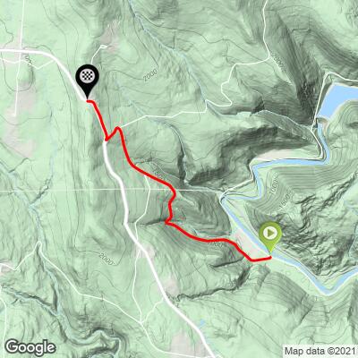
ROUTE MAP
MEMBER RATING
CURRENT WEATHER
PJAMM TRIPS ADVENTURE STARTER BUNDLES
Check out PJAMM Adventure's prepackaged (self-guided) cycling trips. They will help you plan, document and conquer your next adventure.
NEARBY CLIMBS (0) RADIAL PROXIMITY
FROM No Climbs Found
MEMBER REVIEWS & COMMENTS
Let us know what you thought of this climb. Signup for our FREE membership to write a review or post a comment.
Already have an account?
LOG IN HERE