0
PDI
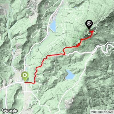
4.2 mi
DISTANCE
1,607 ft
GAINED
7.2 %
AVG. GRADE
FULL CLIMB STATS
INTRO
Ride into Grandfather State Park up to just below the popular and iconic Mile High Swinging Bridge.
Cycle the entire Blue Ridge Parkway – see PJAMM’s March 2022, 467-mile adventure on the PJAMM Adventures App: Blue Ridge Parkway. See also our Climbs of the BRP (NC to VA) and Climbs of the BRP (VA to NC).
PLAN YOUR ROUTE
This climb has an average grade of 7.3%. 62% of the climb is at 5-10%, 17% is at 10-15%, and the final 2% (1/10th of a mile) is at 15-20%. The steepest quarter-mile is 13.3%.
See more details and tools regarding this climb's grade via the “Profile Tool” button.
Roadway: The first 2.1 miles are on Blowing Rock Highway (Route 221), a two lanes road with a double yellow stripe in good condition. The final two miles up Grandfather Mountain Entrance Road are on a pristine two lane roadway with ten hairpins along the way.
Traffic: Light to moderate, depending on the time of day and season.
Fee: There is a toll booth at the start of Grandfather Mountain Entrance Road - be prepared to pay a fee to enter the park. As of 2021 the fee was $22 (Tickets and Reservations).
Parking: There are several businesses at the start of the climb that will likely permit you to leave your car while you ride, or try parking behind the US Post Office at the start of the climb (Map; Street View).
Provisions: In Linville at the start of the climb or at Mildred's Grill at mile 3.2 (Google Map + Reviews).
Before heading out on any cycling adventure check out our Things to Bring on a Cycling Trip and use our interactive check list to ensure you don't forget anything.
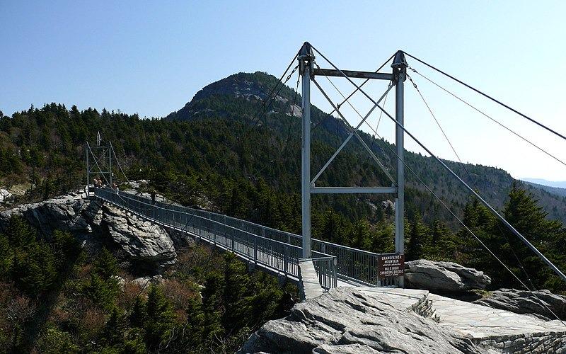
Grandfather Mountain State Park is an extremely popular place to visit, explore, hike and enjoy (Google Map + Reviews - 5 Star rating) - see the park's Things to Do Page. Be sure to walk the Mile High Swinging Pedestrian Bridge which is the highest suspension footbridge in the US - this is accessed at the upper parking lot at the finish of your climb.
ROUTE MAP
MEMBER RATING
CURRENT WEATHER
PJAMM TRIPS ADVENTURE STARTER BUNDLES
Check out PJAMM Adventure's prepackaged (self-guided) cycling trips. They will help you plan, document and conquer your next adventure.
NEARBY CLIMBS (0) RADIAL PROXIMITY
FROM No Climbs Found
MEMBER REVIEWS & COMMENTS
Let us know what you thought of this climb. Signup for our FREE membership to write a review or post a comment.
Already have an account?
LOG IN HERE
dpnstl
I tried to do this climb today only to find out that they no longer allow cyclists, or pedestrians, inside the gates....it's not a park and is owned by a 501c3 that made this rule...