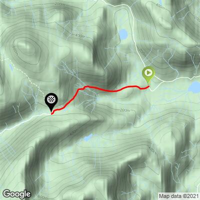
Wrynose Pass East (SW #85) Bike Climb - PJAMM Cycling

3.2
FIETS
1.6 mi
DISTANCE
939 ft
GAINED
11.4 %
AVG. GRADE

FULL CLIMB STATS

INTRO

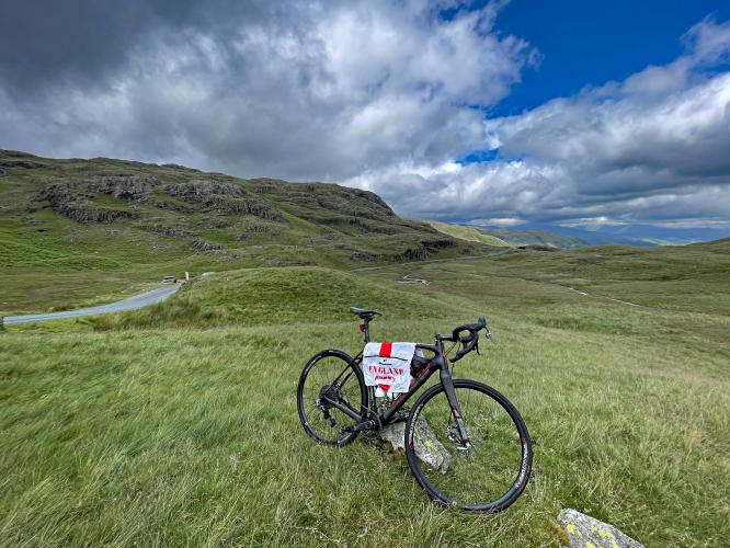
Wrynose Pass from the east is one of the top climbs in the United Kingdom and England and is in close proximity to two other Top 10 climbs, Hardknott and Kirkstone Passes.  This is the final climb of the annual Fred Whitton Saddle Back Challenge, one of the most popular sport events in the UK.  This is a very remote and difficult climb in the middle of Lake District National Park. 

Visit our Top UK and also our Top English hill climbs pages for photos, summaries and statistics for their respective top hill climbs. 

See more details and tools regarding this climb's grade via our interactive Profile Tool.
Information Not Available

If you have any information regarding this climb, we'd like to hear from you. Click the CONTRIBUTE button to share your thoughts with us.

Information Not Available

If you have any information regarding this climb, we'd like to hear from you. Click the CONTRIBUTE button to share your thoughts with us.

Before heading out on any cycling adventure check out our Things to Bring on a Cycling Trip and use our interactive check list to ensure you don't forget anything.
Information Not Available

If you have any information regarding this climb, we'd like to hear from you. Click the CONTRIBUTE button to share your thoughts with us.

ROUTE MAP

MEMBER RATING

Not Yet Rated
-
Road
-
Traffic
-
Scenery

CURRENT WEATHER

PJAMM TRIPS ADVENTURE STARTER BUNDLES

Check out PJAMM Adventure's prepackaged (self-guided) cycling trips. They will help you plan, document and conquer your next adventure.
ALL TRIPS
Browse all of our prepackaged trips and find your next adventure!

NEARBY CLIMBS (0) RADIAL PROXIMITY

FROM
No Climbs Found

MEMBER REVIEWS & COMMENTS

Let us know what you thought of this climb. Signup for our FREE membership to write a review or post a comment.
Already have an account?
ROUTE MAP
PROFILE TOOL
Route Data
S.G. (%)
hide
Segment Data
hide

Climb Profile Not Found
CLIMB SUMMARY

photo shows view down one-lane mountain roadway on foggy, wet day 

Cycling Wrynose Pass East

Ride 1.6 miles gaining 939’ at 11.4% average grade.

Wrynose Pass from the east is the gateway to some of the most scenic miles in all of Britain. The opening yards pass a few farms, but you’ll soon be on the steep slopes of the mountain - with no points of respite until the summit point. Nearing the summit, rocky mountain tops and boulders surround you as a sweeping left hand turn offers views of the farming land far below. Crest the top, and ahead is a remarkable crescent into a magnificent and relatively untouched valley. While a tough climb on its own, Wrynose Pass takes you into the heart of the Lake District and it would be a crime not to continue the ride west from the summit point and into the valley.

photo collage; views along mountainside on wet, foggy day, road sign warns of 25% grades, small waterfall along mountainside

This is a very remote and difficult climb in the middle of Lake District National Park.  The first 250 meters of the climb average 12%, and the first two kilometers are an extremely challenging 13.2% average grade (the final 700 meters of that first segment are at a brutal 17.5%).  Hang in there because you can almost coast the final 500 meters to the summit (3.6% average).  

bike parked in front of cattle guard, green pastureland

Start of the climb in the Little Langdale Valley.

This is the final climb of the annual Fred Whitton Saddle Back Challenge, one of the most popular sportives in the UK and is one of the toughest of England’s climbs with a quarter-mile averaging 18%.  See the PJAMM Fred Whitton Challenge Climb Page for more information on this cycle climbing event.  Wrynose Pass is ranked six in England and 14 in the United Kingdom using the Fiets Index, and ranked by Simon Warren as #5 on the England Top 10 list he provided for us before our 2022, two-month tour of the UK to document the top and most epic bike climbs here.

photo collage shows views of quintessential English countryside, including creek surrounded by pastureland and old stone farm buildings

The National Trust owns many farms and areas of land in this area.

photo collage shows bike parked next to stone retaining wall, small streams behind

Many streams in view as we ascend.

photo collage shows bike parked in grassy hillside along roadside

“If Hardknott is the king of climbs, then Wrynose is its queen; slightly softer at the edges but no less ruthless,”  Simon Warren (100 Greatest Cycling Climbs, A Road Cyclist’s Guide to Britain’s Hills, p. 145).

photo collage shows hillsides in fall colors during September, road sign for 25% grade

Fall colors during our September 2022 climb.

These climbs are within Lake District National Park, 236,200 hectares (583,663 acres) established in 1951:

“The Lake District, also known as the Lakes or Lakeland, is a mountainous region in North West England. A popular holiday destination, it is famous for its lakes, forests and mountains (or fells) and its associations with the early 19th century writings of William Wordsworth and the other Lake Poets, Beatrix Potter, and John Ruskin. A National Park was established in 1951 and, following a minor extension in 2016, now covers an area of approximately 2,362 square kilometres. It was designated as a UNESCO World Heritage Site in 2017.

It is located entirely within the county of Cumbria, and all the land in England higher than 3,000 feet (914 m) above sea level lies within the National Park, including Scafell Pike, the highest mountain in England. It also contains the deepest and longest bodies of water in England, respectively Wast Water and Windermere” (
Wikipedia - Lake District National Park).

photo collage shows hillsides and landscape in green during July, sheep grazing in heather

Summer colors during our July 2018 trip.

aerial drone view show green hillsides and one-lane country road

Upper photos show the final approach to the pass.

bike parked next to old wooden sign at climb's summit

Summit.

aerial drone view shows views looking back over entire climb, including start near Der Little Langdale Tarn

Aerial view from the finish back to the start near Der Little Langdale Tarn.

That’s a wrap!

Access to full Climb Summary requires a PJAMM Cycling PRO Membership!

It takes less than a minute to sign up & with your PRO membership you can:
  • Rate climbs, post comments and share your experiences on any of our climb pages
  • Create bucket lists of climbs & mark the dates you complete them
  • Weather data for all climbs - Start & Finish
  • Upload photos to your member page to customize your PJAMM Cycling experience
  • Utilize all of our interactive tools - Profile & Routes in Area
  • Download climb route .gpx files
LEARN MORE
SIGN UP

Already have an account? LOG IN HERE