Cycling The Tumble, Wales
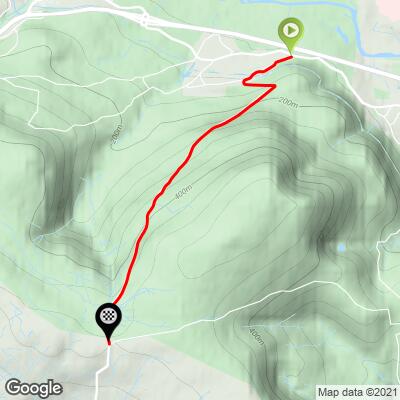
Ride 3.1 miles gaining 1,250’ at 7.8% average grade.
The Tumble is the seventh most difficult climb in Wales via the Fiets Index. The climb is a good distance at nearly five kilometers, and averages just over an 8% average grade. There is a 2.5 kilometer 10.5% segment beginning 600 meters from the start that puts us to the test right away.

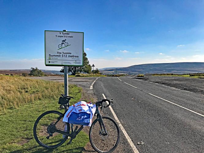
This climb has been included in many British cycling events, which is obvious from the start, with a “Start of Climb” sign designating the beginning of the 2018 Iron Mountain Sportif, and also a cycling summit sign at the climb’s finish.

No question where climb begins.
The Tumble was the venue for the 2021 Welsh CA Hill Climb Championship won by Dan Evans on the men's side and Rebecca Richardson on the women’s. The Tumble has also been included in the Tour of Britain.

Climb begins by riding up B4246 towards Blaenavon.

Making friends at the start of the climb 😊

World Heritage site sign at ~ 100 yards of the climb.
Big Pit is a coal mine and one of Britain’s leading mining museums.
“The landscape of Blaenavon, at the upper end of the Avon Llwyd valley in South Wales, provides exceptional testimony to the area’s international importance in iron making and coal mining in the late 18th and the early 19th century. The parallel development of these industries was one of the principal dynamic forces of the Industrial Revolution.
The major preserved sites of Blaenavon Ironworks and Big Pit, together with the outstanding relict landscape of mineral exploitation, manufacturing, transport, and settlement which surrounds them, provide an extraordinarily comprehensive picture of all the crucial elements of the industrialisation process: coal and ore mines, quarries, a primitive railway system and canal, furnaces, workers’ homes, and the social infrastructure of the early industrial community. The area reflects the pre-eminence of South Wales in the production of iron, steel and coal in the 19th century.” Read more at the Unesco World Heritage #984 - Blaenavon Page.

Monmouthshire and Beacon Canal at 400 meters.
The Tumble climbs up from what seems to be a very upscale neighborhood for a mile or so. Past these nice homes and over a few cattle guards, the climb opens up while the gradients stay relatively mild. Some retired mines are visible to your right as you make your way up to the summit pond. This pond seems to be a popular attraction and you can expect a fair bit of traffic on the road. We parked our car near the base of the climb in a dirt lot where a public trail started, however parking is widely available at the summit of the climb near the pond as well.

Forest and tree coverage for the first third of the climb.

The final two-thirds of the climb offer open views of the countryside.

Sheep crossing at mile 1.8
We have documented climbs in over 30 countries and have never seen more sheep than in Wales. There are an estimated 10,000,000 sheep in Wales, which equals about one-third of the total number in all of Britain. However, the population of Britain is 67.22 million, while Wales’ population is 3.1, meaning Wales has less than a twentieth of the human population of Britain. That’s a lot of sheep!

Two hairpins from mile 0.5 to 0.7 averaging 10.1%.
This climb is located in the eastern section of Brecon Beacons National Park, Wales (established 1957, 134,420 hectares/332,160 acres). This is the third of the three Welsh parks (Snowdonia and Pembrokeshire Coast being the other two). Brecon Beacons NP covers a 519 square mile area between Llandeilo in the west, to Hay-on-Wye in the northeast, and Pontypool in the southeast. In February 2013, Brecon Beacons received International Dark Sky Reserve status. The park contains mostly grassy moorland where its common to see Welsh mountain ponies and mountain sheep grazing, but also includes forestry, valleys, reservoirs, waterfalls, and caves. Because of the park’s remote location and the harsh weather in its uplands, Brecon Beacons is used as a site for UK Special Forces military training. You can read more about Brecon Beacons National Park here.

That’s a wrap!
3.1 miles at 7.8%.
Simon Warren (100 Greatest Climbs) writes that The Tumble is “one of the most feared and frequently raced climbs in Wales. The Tumble offers an excellent challenge to any rider” (100 Greatest Cycling Climbs, pp. 164-165).

Keepers Pond is just past the finish of this climb.
If you can tolerate the frigid temperatures, you can swim in Keepers Pond. From the pond there are fantastic views of the valley far below and mountains beyond that.
CyclingUphill.com writes of this climb:
“I was staying in Forest of Dean this weekend, so I thought I’d cycle out to the Tumble – a climb that has featured in many Tour of Britain’s and something I’ve watched quite a few times on the TV.
In theory, it was 25 miles from the Forest of Dean to the base of the Tumble in Govilon, Abergavenny. But, I trusted my instinct of ‘remembering the roads’ from five minutes of studying the map, rather than taking it with me. I once did the National 50 mile TT on the A40 around Raglan. But, that wasn’t much help, and I ended up taking a long detour on an unknown Welsh road to Usk. I kept hoping to cut across to Blaenavon, but didn’t have much luck. At one point, I went a long way up a mountain road to be greeted by a dead end sign – right at the end of the road. 40 miles later I did finally make it to Gavilon, and in between hail showers climbed up the Tumble.
It’s a good climb. The first half is a consistent 10% up a few hairpins, perhaps steeper in parts. As you go out of the trees, the gradient eases off a little and if there’s a tailwind you can pick up a little speed. It’s quite exposed at the top. It was popular with other cyclists, I must have seen a good 20-30 on various parts of the climb. I managed to overtake a couple on the way up. I had forgotten my cycling jacket so was just wearing loose under clothes, and had a camera swinging from thigh to thigh on the way up, which was irritating. I didn’t look the part, but still went up in a respectable time for February, on a winter training bike” (read more).