IRONMAN Switzerland Thun Triathlon - PJAMM Cycling

BIKE STATS:
0 mi
DISTANCE
0 ft
PEAK ELEV.
0 ft
ELEV. GAINED
0 %
STEEPEST ¼ mi

FULL COURSE STATS

INTRO

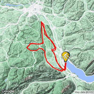
Racing in the Swiss alps of Thun is said by many to be their best Ironman experience ever - this is quite possibly the most beautiful race in the world. Considering it's location, the bike course is a lot less hilly than they could've made it, or could make it in the future....

Switzerland Thun is a full distance triathlon located in Thun, Switzerland. The swim is 3.8 km, bike is 180 km, and the run is 42 km.  Use the profile tool, route maps, weather forecast, and other tools on this page to more efficiently and effectively train for your race. 

Explore and compare other triathlons and Ironman races on our Triathlon Homepage.
Full Event Schedule

Parking:
Race day parking is at Panorama-Center shopping mall.  A shuttle will take athletes and spectators to Ironman village (starting at 4:30am), otherwise it's a 20-30 minute walk.

Historical Weather:
Summers in Switzerland are mild, cool in the mornings, and sunny for around 2/3 of the month.  Check the PJAMM Cycling Weather Tool for current and historic weather data.

Local Tri Shops:

Local Public Pools:

Popular open water swim areas:
- Thunersee** (race venue)
Information Not Available

If you have any information regarding this triathlon, we'd like to hear from you. Click the CONTRIBUTE button to share your thoughts with us.

COURSE MAP

CURRENT WEATHER

PJAMM TRIPS ADVENTURE STARTER BUNDLES

Check out PJAMM Adventure's prepackaged (self-guided) cycling trips. They will help you plan, document and conquer your next adventure.
ALL TRIPS
Browse all of our prepackaged trips and find your next adventure!
140.6 Switzerland - Thun
Switzerland
3 ROUTES
12 POIs
ROUTE STATS (TOTAL)
140
mi
DISTANCE
6,529
ft
ELEV. GAIN

NEARBY BIKE CLIMBS (0) RADIAL PROXIMITY

FROM
No Climbs Found

MEMBER COMMENTS

Let us know your thoughts about this triathlon. Signup for our FREE membership to post a comment or question.
Already have an account?
ROUTE MAP
WEATHERView Tutorial

Use of the Weather Tool requires a PJAMM Cycling FREE Membership!

It takes less than a minute to sign up & with your FREE membership you can:
  • Rate climbs, post comments and share your experiences on any of our climb pages
  • Create bucket lists of climbs & mark the dates you complete them
  • Weather data for all climbs - Start Only
    (Weather at climb Finish requires a PRO Membership)
Take a video tour:
LEARN MORE
SIGN UP

Already have an account? LOG IN HERE

PROFILE TOOL
Route Data
S.G. (%)
hide
Segment Data
hide

Climb Profile Not Found
RACE REVIEW

IRONMAN Thun Bike Course Analysis
Swiss Alps

Overall Surface Quality:

Great - Swiss roads are maintained annually

Strava rides of last year’s winners (or runner up):

Jan Van Berkel, (4:20:14 / 41.5 kph); https://www.strava.com/activities/5910240392 

Strava Segment:

https://www.strava.com/segments/23105519 

Significant Ascents:

Climb up from the lake (@ km 2.7 and 92)

  • Climb has 2 parts, starting with 1km of 4.6% and ending with 2km of 4%
  • Peaks at 6%

Roller after Uetendorf (@ km 15.9 and 105)

  • 800 meter long hill breaking 8%

Roller into Kirchdorf (@ km 24.8 and 114)

  • 500 meter long hill breaking 12%

Climb out of Toffen (@ km 41.8 and 130.6)

  • Biggest climb in the course

Neuhaus Climb (@ km 54.7 and 144)

  • Two steep <1km long sections hitting +6%; 185 meters gained in total
  • Reaches highest elevation of the course, 896 meters
  • Followed by a significant 8km long descent with technical sections (km 68)

Hauptstrasse Climb (@ km 70 and 160)

  • Rolling sections of 4% and 5% scattered among false flats
  • Last significant climb on the course (will do twice at the end of each lap)

Click here to view a full interactive profile of the 112 mile course.


Turn by Turn Course Recon:

*Turn angle is measured by the sharpest corner angle throughout the entire turn*

Click thumbnail for example (66˚ turn)

The bike course is winding with 52 turns per lap. There are only a few that are technical:

127˚ right turn  @ km 17.6 and 106.9

Entrance gradient (preceding 100 meters):  -6.9%

Exit gradient (next 100 meters):  -2.1%                        

Google Street View


65˚ left turn  @ km 20.4 and 125.8

Entrance gradient (preceding 100 meters):  -4.8%

Exit gradient (next 100 meters):  -2.3%                        

Google Street View


180˚ left turn  @ km 26.5 and 109.8

Entrance gradient (preceding 100 meters):  2.4%

Exit gradient (next 100 meters):  2.5%                        

Google Street View


103˚ left turn  @ km 54.3 and 143.7

Entrance gradient (preceding 100 meters):  -2%

Exit gradient (next 100 meters): -0.4%                        

Google Street View


170˚ left turn  @ km 64.4 and 153.8

Entrance gradient (preceding 100 meters):  -9.2%

Exit gradient (next 100 meters):  -2.5%                        

Google Street View


Double hairpins  @ km 68 and 158

  • Turn sequence averages -7.5%
  • Preceded by 1km of -6% and -7% gradients

Google Street View Turn 1

Google Street View Turn 2


Transition Layout:

Obstacles and Other Notes:

Current / Historical Weather Patterns

Full Interactive Bike Course Profile

Link to main race site:

https://www.ironman.com/im-switzerland 

Notice an error,  have a suggestion, or an update to this information? Contact us at samlyons@pjammcycling.com!