INTRO
If you have any information regarding this triathlon, we'd like to hear from you. Click the CONTRIBUTE button to share your thoughts with us.
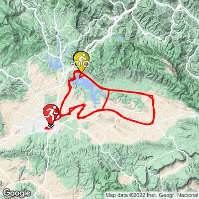
COURSE MAP


If you have any information regarding this triathlon, we'd like to hear from you. Click the CONTRIBUTE button to share your thoughts with us.

IRONMAN Vitoria-Gasteiz Bike Course Analysis
Overall Surface Quality:
Excellent
Significant Ascents:
Click here to view a full interactive profile of the 112 mile course.
Last year’s fastest times:
Male: Yannick Matejicek, 4:28:59 / 40.2 kph
Female: Sera Sayar, 5:14:12 / 34.4 kph
Last year’s median age-grouper times:
Male: 6:17 / 28.6 kph
Female: 7:01 / 25.7 kph
Strava Activity of last year’s Champion (or runner up):
Different course used
Male: https://www.strava.com/activities/6184081024
Female: https://www.strava.com/activities/5950844356
Transition Layout:
Turn by Turn Course Recon:
*Turn angle is measured by the sharpest corner angle throughout the entire turn*
Click thumbnail for example (66˚ turn)
Turn 1:
90˚ Left turn; Km 5.2
Entrance gradient (preceding 100 meters): -1.1%
Exit gradient (next 100 meters): -1.2%
Turn 2:
90˚ Right turn; Km 18.3
Entrance gradient (preceding 100 meters): -2.5%
Exit gradient (next 100 meters): -1.5%
Turn 3:
123˚ right turn; Km 24.8
Entrance gradient (preceding 100 meters): -1.9%
Exit gradient (next 100 meters): -1.4%
Turn 4:
105˚ right turn; Km 38.3
Entrance gradient (preceding 100 meters): -2.8%
Exit gradient (next 100 meters): 0%
Turn 5:
106˚ left turn; Km 38.5
Entrance gradient (preceding 100 meters): 0%
Exit gradient (next 100 meters): 1.6%
Turn 6:
80˚ right turn; Km 43.7
Entrance gradient (preceding 100 meters): -0.6%
Exit gradient (next 100 meters): -0.6%
Turn 7:
47˚ left turn; Km 43.7
Entrance gradient (preceding 100 meters): -0.6%
Exit gradient (next 100 meters): -0.6%
Turn 8:
80˚ right turn; Km 44
Entrance gradient (preceding 100 meters): -0.2%
Exit gradient (next 100 meters): 0%
Turn 9:
97˚ left turn; Km 48
Entrance gradient (preceding 100 meters): 5.1%
Exit gradient (next 100 meters): 3.8%
Turn 10:
50˚ left turn; Km 51.8
Entrance gradient (preceding 100 meters): -3.8%
Exit gradient (next 100 meters): -3.1%
Turn 11:
90˚ right turn; Km 52.6
Entrance gradient (preceding 100 meters): -1%
Exit gradient (next 100 meters): -1.4%
Turn 12:
106˚ left turn; Km 52.7
Entrance gradient (preceding 100 meters): -1.9%
Exit gradient (next 100 meters): -1%
Turn 13:
88˚ right turn; Km 52.9
Entrance gradient (preceding 100 meters): 0.1%
Exit gradient (next 100 meters): -0.1%
Turn 14:
90˚ right turn; Km 53.3
Entrance gradient (preceding 100 meters): 0%
Exit gradient (next 100 meters): 0%
Turn 15:
119˚ right turn; Km 56.4
Entrance gradient (preceding 100 meters): 0%
Exit gradient (next 100 meters): -0.3%
Turn 16:
54˚ left turn; Km 63.8
Entrance gradient (preceding 100 meters): 0%
Exit gradient (next 100 meters): 0%
Turn 17:
39˚ right turn; Km 64.6
Entrance gradient (preceding 100 meters): 0%
Exit gradient (next 100 meters): 1.6%
Turn 18:
43˚ left turn; Km 67.1
Entrance gradient (preceding 100 meters): 2.4%
Exit gradient (next 100 meters): 1.2%
Turn 19:
39˚ right turn; Km 68.9
Entrance gradient (preceding 100 meters): 2.4%
Exit gradient (next 100 meters): -2.2%
Turn 20:
40˚ left turn; Km 69.1
Entrance gradient (preceding 100 meters): 3.6%
Exit gradient (next 100 meters): -2.1%
Turn 21:
35˚ left turn; Km 70.3
Entrance gradient (preceding 100 meters): 3.6%
Exit gradient (next 100 meters): -2%
Turn 22:
124˚ right turn; Km 71.5
Entrance gradient (preceding 100 meters): 0%
Exit gradient (next 100 meters): 0%
Repeat all for lap 2
Turn 45:
85˚ right turn; Km 152.5
Entrance gradient (preceding 100 meters): -1.1%
Exit gradient (next 100 meters): -1.1%
Turn 46:
36˚ right turn; Km 152.5
Entrance gradient (preceding 100 meters): 1%
Exit gradient (next 100 meters): 0%
Repeat turns 6 - 14
Turn 46:
73˚ left roundabout turn; Km 175
Entrance gradient (preceding 100 meters): -0.3%
Exit gradient (next 100 meters): 0.3%
Turn 47:
50˚ right turn; Km 176.5
Entrance gradient (preceding 100 meters): 0%
Exit gradient (next 100 meters): 1.6%
Turn 48:
125˚ left turn; Km 177.2
Entrance gradient (preceding 100 meters): 1.3%
Exit gradient (next 100 meters): 1.3%
Turn 49:
70˚ left turn; Km 178.2
Entrance gradient (preceding 100 meters): 2.1%
Exit gradient (next 100 meters): 1.8%
Turn 50:
90˚ right turn; Km 179
Entrance gradient (preceding 100 meters): 2.8%
Exit gradient (next 100 meters): 0.8%
Obstacles and Other Notes:
Current / Historical Weather Patterns
Full Interactive Bike Course Profile
Link to main race site:
https://www.ironman.com/im-vitoria
Notice an error, have a suggestion, or an update to this information? Contact us at samlyons@pjammcycling.com!