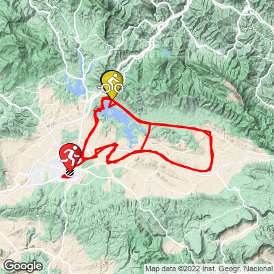
IRONMAN Vitoria-Gasteiz Bike Course Analysis
Overall Surface Quality:
Excellent
Significant Ascents:
- Before the left turn onto A-3012, there’s a 0.5 km segment that breaks 8%. You’ll do this climb 3 times, at km 7, km 79, and km 151
![]()
- There are rollers when you approach the lake near the end of each lap, the most significant of which breaking 6%. You will do this twice at km 64 and km 136
![]()
- The steepest gradient on the course comes at km 154 and lasts less than half of a km. This peaks at just under 10%. You will only do this once as you make the final turn after 2 full laps to head into the city.
![]()
Click here to view a full interactive profile of the 112 mile course.
Last year’s fastest times:
Male: Yannick Matejicek, 4:28:59 / 40.2 kph
Female: Sera Sayar, 5:14:12 / 34.4 kph
Last year’s median age-grouper times:
Male: 6:17 / 28.6 kph
Female: 7:01 / 25.7 kph
Strava Activity of last year’s Champion (or runner up):
Different course used
Male: https://www.strava.com/activities/6184081024
Female: https://www.strava.com/activities/5950844356
Transition Layout:
- T1 is straightforward, a direct path from the water to the road. See page 36
- There’s a confusing two part T2, located on different streets. See page 48 of the athlete guide for full details and layout.
Turn by Turn Course Recon:
*Turn angle is measured by the sharpest corner angle throughout the entire turn*
Click thumbnail for example (66˚ turn)
![]()
Turn 1:
90˚ Left turn; Km 5.2
Entrance gradient (preceding 100 meters): -1.1%
Exit gradient (next 100 meters): -1.2%
![]()
Google Street View
Turn 2:
90˚ Right turn; Km 18.3
Entrance gradient (preceding 100 meters): -2.5%
Exit gradient (next 100 meters): -1.5%
![]()
Google Street View
Turn 3:
123˚ right turn; Km 24.8
Entrance gradient (preceding 100 meters): -1.9%
Exit gradient (next 100 meters): -1.4%
![]()
Google Street View
Turn 4:
105˚ right turn; Km 38.3
Entrance gradient (preceding 100 meters): -2.8%
Exit gradient (next 100 meters): 0%
- Turn enters a poorly lit underpass
- Be cautious of concrete safety poles sticking out of the ground!
![]()
Google Street View
Turn 5:
106˚ left turn; Km 38.5
Entrance gradient (preceding 100 meters): 0%
Exit gradient (next 100 meters): 1.6%
![]()
Google Street View
Turn 6:
80˚ right turn; Km 43.7
Entrance gradient (preceding 100 meters): -0.6%
Exit gradient (next 100 meters): -0.6%
![]()
Google Street View
Turn 7:
47˚ left turn; Km 43.7
Entrance gradient (preceding 100 meters): -0.6%
Exit gradient (next 100 meters): -0.6%
![]()
Google Street View
Turn 8:
80˚ right turn; Km 44
Entrance gradient (preceding 100 meters): -0.2%
Exit gradient (next 100 meters): 0%
![]()
Google Street View
Turn 9:
97˚ left turn; Km 48
Entrance gradient (preceding 100 meters): 5.1%
Exit gradient (next 100 meters): 3.8%
![]()
Google Street View
Turn 10:
50˚ left turn; Km 51.8
Entrance gradient (preceding 100 meters): -3.8%
Exit gradient (next 100 meters): -3.1%
![]()
Google Street View
Turn 11:
90˚ right turn; Km 52.6
Entrance gradient (preceding 100 meters): -1%
Exit gradient (next 100 meters): -1.4%
- Sharp zero visibility turn around building
![]()
Google Street View
Turn 12:
106˚ left turn; Km 52.7
Entrance gradient (preceding 100 meters): -1.9%
Exit gradient (next 100 meters): -1%
![]()
Google Street View
Turn 13:
88˚ right turn; Km 52.9
Entrance gradient (preceding 100 meters): 0.1%
Exit gradient (next 100 meters): -0.1%
![]()
Google Street View
Turn 14:
90˚ right turn; Km 53.3
Entrance gradient (preceding 100 meters): 0%
Exit gradient (next 100 meters): 0%
![]()
Google Street View
Turn 15:
119˚ right turn; Km 56.4
Entrance gradient (preceding 100 meters): 0%
Exit gradient (next 100 meters): -0.3%
![]()
Google Street View
Turn 16:
54˚ left turn; Km 63.8
Entrance gradient (preceding 100 meters): 0%
Exit gradient (next 100 meters): 0%
![]()
Google Street View
Turn 17:
39˚ right turn; Km 64.6
Entrance gradient (preceding 100 meters): 0%
Exit gradient (next 100 meters): 1.6%
![]()
Google Street View
Turn 18:
43˚ left turn; Km 67.1
Entrance gradient (preceding 100 meters): 2.4%
Exit gradient (next 100 meters): 1.2%
![]()
Google Street View
Turn 19:
39˚ right turn; Km 68.9
Entrance gradient (preceding 100 meters): 2.4%
Exit gradient (next 100 meters): -2.2%
![]()
Google Street View
Turn 20:
40˚ left turn; Km 69.1
Entrance gradient (preceding 100 meters): 3.6%
Exit gradient (next 100 meters): -2.1%
![]()
Google Street View
Turn 21:
35˚ left turn; Km 70.3
Entrance gradient (preceding 100 meters): 3.6%
Exit gradient (next 100 meters): -2%
![]()
Google Street View
Turn 22:
124˚ right turn; Km 71.5
Entrance gradient (preceding 100 meters): 0%
Exit gradient (next 100 meters): 0%
![]()
Google Street View
Repeat all for lap 2
Turn 45:
85˚ right turn; Km 152.5
Entrance gradient (preceding 100 meters): -1.1%
Exit gradient (next 100 meters): -1.1%
![]()
Google Street View
Turn 46:
36˚ right turn; Km 152.5
Entrance gradient (preceding 100 meters): 1%
Exit gradient (next 100 meters): 0%
![]()
Google Street View
Repeat turns 6 - 14
Turn 46:
73˚ left roundabout turn; Km 175
Entrance gradient (preceding 100 meters): -0.3%
Exit gradient (next 100 meters): 0.3%
![]()
Google Street View
Turn 47:
50˚ right turn; Km 176.5
Entrance gradient (preceding 100 meters): 0%
Exit gradient (next 100 meters): 1.6%
![]()
Google Street View
Turn 48:
125˚ left turn; Km 177.2
Entrance gradient (preceding 100 meters): 1.3%
Exit gradient (next 100 meters): 1.3%
![]()
Google Street View
Turn 49:
70˚ left turn; Km 178.2
Entrance gradient (preceding 100 meters): 2.1%
Exit gradient (next 100 meters): 1.8%
![]()
Google Street View
Turn 50:
90˚ right turn; Km 179
Entrance gradient (preceding 100 meters): 2.8%
Exit gradient (next 100 meters): 0.8%
![]()
Google Street View
Obstacles and Other Notes:
- Point to point bike course
- Confusing 2 part T2 - see page 48 for the full details and layout
- Several roundabouts and concrete curbs to watch out for during the last few km into downtown
Current / Historical Weather Patterns
Full Interactive Bike Course Profile
Link to main race site:
https://www.ironman.com/im-vitoria
Notice an error, have a suggestion, or an update to this information? Contact us at samlyons@pjammcycling.com!
![]()