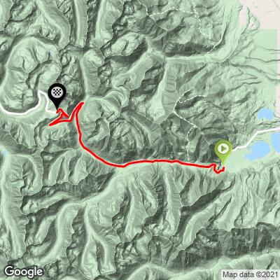
14.9
PDI
15.5 mi
DISTANCE
2,867 ft
GAINED
3.5 %
AVG. GRADE
FULL CLIMB STATS
Page Contributor(s): Christopher Jacobs, Byers CO, USA
INTRO
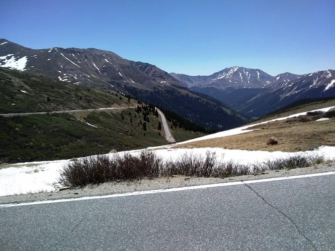
The "other" side of Independence Pass - heading to Aspen from the east from Vail. This is a scenic bike ride on a lightly used highway with no oversized vehicles.
PLAN YOUR ROUTE
3.5% average grade. 64% of thw climb is at 0-5% grade and 31% is at 5-10%. The steepest quarter mile is 8.8%.
See more details and tools regarding this climb's grade via the “Profile Tool” button above.
Roadway: 2 lane highway, well maintained and in good condition with no to a narrow shoulder.
Traffic: Light and no oversized vehicles (nothing over 35') are allowed.
Parking: There is a big dirt parking area at the start of the climb - Map; Street View.
Provisions: There is a general store in Twin Lakes 2 miles east of the climb start.
Weather: This climb ends above 12,000' so be sure to consult the PJAMM "Full Forecast" feature for the time you expect to arrive at the finish to assess what clothing to bring on your ride.
Before heading out on any cycling adventure check out our Things to Bring on a Cycling Trip and use our interactive check list to ensure you don't forget anything.
Adding Independence Pass West would be a great out-and-back which would involve 30 miles of riding and nearly 7,000' of climbing.
We stay in Aspen when riding Independence Pass. Aspen has many hotels and lodges to choose from, in addition to outstanding villa and condo rentals in this popular ski resort area. A challenging and scenic out-and-back is tacking Independence Pass East onto the climb from Aspen which makes for a 60 miles 6,700' out-and-back ride.
Use the Routes in Area Tool to see other great bike climbs in this area.
ROUTE MAP
MEMBER RATING
CURRENT WEATHER
PJAMM TRIPS ADVENTURE STARTER BUNDLES
Check out PJAMM Adventure's prepackaged (self-guided) cycling trips. They will help you plan, document and conquer your next adventure.
NEARBY CLIMBS (0) RADIAL PROXIMITY
FROM No Climbs Found
MEMBER REVIEWS & COMMENTS
Let us know what you thought of this climb. Signup for our FREE membership to write a review or post a comment.
Already have an account?
LOG IN HERE
zesoloist


Knocked this out midweek while acclimating for the Leadville 100 MTB race. Rode as an out and back from Leadville with some of the approach along the race course (rolling dirt road instead of heavier traffic HWY 24). Once at Twin Lakes the traffic is low due to a 35’ vehicle restriction at the switchbacks. Watch out for some rough/uneven spots and potholes if you descend back to Twin Lakes. The little store at Twin Lakes has everything you need to refuel.