Bear Creek Road - Lexington Reservoir Bike Climb - PJAMM Cycling

10.1
PDI
2.9 mi
DISTANCE
1,371 ft
GAINED
8.9 %
AVG. GRADE

FULL CLIMB STATS

Page Contributor(s): Dan Razum, Campbell, CA, USA

INTRO

This 2.9 mile bike climb is located in CA, USA. The average gradient is 8.9% and there is a total elevation gain of 1,371 ft, finishing at 2,008 ft.

Use the profile tool, route map, and weather forecast to conquer this cycling climb.

PLAN YOUR ROUTE

We've partnered with Sherpa-Map.com to bring you the best route planning tool. With a PRO Membership you can use this climb as a reference when creating your route.

See more details and tools regarding this climb's grade via our interactive Profile Tool.
Information Not Available

If you have any information regarding this climb, we'd like to hear from you. Click the CONTRIBUTE button to share your thoughts with us.

Information Not Available

If you have any information regarding this climb, we'd like to hear from you. Click the CONTRIBUTE button to share your thoughts with us.

Before heading out on any cycling adventure check out our Things to Bring on a Cycling Trip and use our interactive check list to ensure you don't forget anything.
Information Not Available

If you have any information regarding this climb, we'd like to hear from you. Click the CONTRIBUTE button to share your thoughts with us.

ROUTE MAP

MEMBER RATING

Difficulty: Challenging
3
Road
2
Traffic
3
Scenery

CURRENT WEATHER

PJAMM TRIPS ADVENTURE STARTER BUNDLES

Check out PJAMM Adventure's prepackaged (self-guided) cycling trips. They will help you plan, document and conquer your next adventure.
ALL TRIPS
Browse all of our prepackaged trips and find your next adventure!
Sonoma County
United States (CA)
19 ROUTES
39 POIs
ROUTE STATS (TOTAL)
269.3
mi
DISTANCE
41,801
ft
ELEV. GAIN

NEARBY CLIMBS (0) RADIAL PROXIMITY

FROM
No Climbs Found

MEMBER REVIEWS & COMMENTS

Let us know what you thought of this climb. Signup for our FREE membership to write a review or post a comment.
Already have an account?

Jun 8, 2024
difficulty: Challenging
scenery: 3
traffic: 2
road: 3
Jun 8, 2024
scenery: 3
traffic: 2
road: 3
I would recommend only descending this road, as well as bear creek starting from boulder creek. There are too many cars and like most climbs in this area, little shoulder. It's steeper than you would like too, but climbs quickly to skyline.
ROUTE MAP
PROFILE TOOL
Route Data
S.G. (%)
hide
Segment Data
hide
CLIMB SUMMARY

Ride 2.9 miles gaining 1,360’ at 9% average grade.

Climb summary by Dan Razum, Campbell, CA.

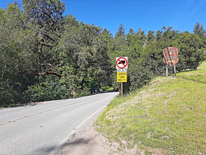
Bear Creek Road goes from Lexington Reservoir up to Summit Road. It is a narrow, twisty road with some

steep sections.  Bear Creek Road is similar to other roads nearby, such as Black, Montevina or

Soda Springs, but with one major difference: traffic.  Bear Creek is a popular route between San Jose

and Boulder Creek. The traffic may not be heavy compared to major highways such as highway 17, but there is

enough traffic to make this a dangerous climb.  The problem is there are many blind curves and most of the

road has absolutely no shoulder. Cars tend to hug the edge of the road around curves and so if they

encounter a cyclist in the middle of the curve, the car has no time to react and the cyclist has nowhere to

escape. This is obviously is not a good situation and so this climb is not recommended, unfortunately.

 Traffic can't see a slow bicycle around this curve, dangerous situation.

As a descent, Bear Creek is ok.  The descent is a little technical but a bicyle can easily keep up with

traffic going downhill.  But if you want to climb up to Summit Road, it is better to use Black Road or

Old Santa Cruz Highway.