Alternate Route 14 Bike Climb - PJAMM Cycling

11.3
FIETS
13.2 mi
DISTANCE
4,840 ft
GAINED
6.7 %
AVG. GRADE

FULL CLIMB STATS

Page Contributor(s): Bruce Hamilton and Stacy Topping.

INTRO

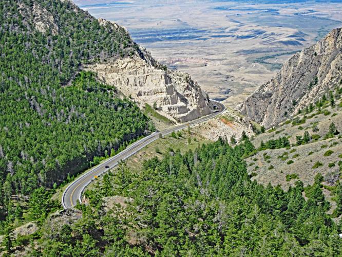
"The most difficult climb in Wyoming, the ascent of giant Alternate 14 starts out on a shallow, steady grade. For the first few miles the road is very straight and you can clearly see your objective ahead. After 6.4 miles the grade increases as you start to clearly see your objective ahead. After 6.4 miles the grade increases as you start to switchback up the hill. Eventually the road clings to the side of a cliff with great views. After entering a gorge, the grade eases, there is a small descent, climbing resumes and then the climb ends (unmarked) at a brake check area for cars which is on your left as you ascend. After a small descent the road continues to gain in elevation but significant climbing has ended..." (This quote presented with the approval of John Summerson from The Complete Guide to Climbing (by Bike), 2nd Edition, p 234.)
Average grade is 6.7% (7.8% with descent eliminated from the gradient equation).  The grade ranges wildly on this one:  10.5% (1.4 miles) is descent;  23% (3.1 miles) is in the 0-5% range; 42.5% (5.6 miles) 5-10%; 20% (2.7 miles) 10-15%; 2.6% (.miles) 15-20% and 1% is at ≥ 20%. Steepest quarter mile is 14.1% and steepest mile 11.3%. 

See more details and tools regarding this climb's grade via the “Profile Tool” button above.
Roadway:  Two lane highway in excellent condition with a shoulder to ride in as needed. 

Traffic:  Mile to moderate with a lot of big rigs going over the pass - this is not a climb (at least for the first few miles before the big right turn at mile 4.2) for for the traffic averse.  Traffic does not seem as much as problem as we begin to climb up the mountain higher and higher. 

Parking:  Not a problem in these parts - park off the side of the road on the side of the unnamed dirt road at climb start - Map;  Street View. 
Provisions:  None on the route.  Closest are in Lovell 18 miles west. 

Weather and Gear:  You finish this climb just over 9,000', nearly 5,000' above where you start - Consult the PJAMM "Full Forecast" feature for the time you expect to arrive at the finish to assess what clothing to bring on your ride.
Before heading out on any cycling adventure check out our Things to Bring on a Cycling Trip and use our interactive check list to ensure you don't forget anything.
Another great Wyoming climb to consider is Granite Pass, 65 miles south of this climb (Map) and Beartooth Pass North from Red Lodge, 88 miles west (Map). 
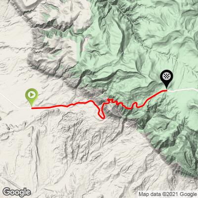
ROUTE MAP

MEMBER RATING

Difficulty: Challenging
4
Road
3
Traffic
4
Scenery

CURRENT WEATHER

PJAMM TRIPS ADVENTURE STARTER BUNDLES

Check out PJAMM Adventure's prepackaged (self-guided) cycling trips. They will help you plan, document and conquer your next adventure.
ALL TRIPS
Browse all of our prepackaged trips and find your next adventure!
Yellowstone and the Tetons
United States (MT,WY)
20 ROUTES
52 POIs
ROUTE STATS (TOTAL)
523.8
mi
DISTANCE
43,011
ft
ELEV. GAIN

NEARBY CLIMBS (0) RADIAL PROXIMITY

FROM
No Climbs Found

MEMBER REVIEWS & COMMENTS

Let us know what you thought of this climb. Signup for our FREE membership to write a review or post a comment.
Already have an account?

Sep 4, 2022
difficulty: Challenging
scenery: 4
traffic: 3
road: 4
Sep 4, 2022
scenery: 4
traffic: 3
road: 4
This climb was harder than expected. Rode Onion Valley and Horseshoe Meadows Rd last month but I think this was the longest section of sustained 10-11% I have climbed. The start is from a mining access road. Lots of truck traffic there but it won't affect your ride. There is a shoulder for the first 3.7 miles however the rumble strip takes up part of it so it was not always possible to be out of the lane. 5 to 6 miles in the road gets rough from damage and repaving.. However after 6 miles there was brand new pavement all the to the top. There is no water but there are some streams I was willing to try. We ride it with two large water bottles and had plenty of water.. This is a remote ride and like most climbs the beautiful parts are in the last few miles. If you have a reason to get in this area I recommend it.
ROUTE MAP
PROFILE TOOL

Climb Profile Not Found
CLIMB SUMMARY

Cycling Alternate Route 14, Wyoming - sign for 10% grade next 13 miles

Cycling Alternate Route 14, Wyoming.  

Ride by bike into the Bighorn Mountains as they rise from the Great Plains.

Cycling Alternate Route 14, Wyoming - photo collage, road sign showing "locations of safety" ahead, views along roadway climbing up Alternate Route 14 over the plains, PJAMM Cycling logo in corner

The bike climb up Alternate Route 14 is thirteen miles,

gaining 5,440’ to 9,090’ at 6.7% average grade.

Alternate U.S. 14 runs east-west across northern Wyoming.  This bike climb is exceptionally scenic, yet one of the more remote Top 50 U.S. Cycling Climbs.  This is the only signed alternate route in Wyoming and is just 65 miles from the start of the other Top 100 Climb in Wyoming (Granite Pass, #53).   The distant views to the south of the Wyoming’s northern plains and mesa formations are phenomenal.  These exceptional views are to our right as we climb out of the “flatlands” (keeping in mind we start the climb at 3,745’) and are with us for at least half the climb until the brutal grade softens a bit as we enter the last segment consisting of rolling hills and grasslands.  

Cycling Alternate Route 14, Wyoming - photo collage, panoramic view of great plains from above, views of mountains along the road, road signs warning of steep grade, PJAMM Cycling logo in corner

We enter Bighorn National Forest just after mile 7.  This is one of the older forests (established 1897) and consists of 1,107,571 acres. Bald Mountain Campground is a few miles past the summit.

Cycling Alternate Route 14, Wyoming - NPS sign for Bighorn National Forest

 Highway 14A is also known as the Medicine Wheel Passage Scenic Byway, formerly Dayton-Kane Highway.

Cycling Alternate Route 14, Wyoming - informational sign for Original Dayton-Kane Highway, US 14A

Cycling Alternate Route 14, Wyoming - looking down on the great plains below cycling on Alternate Route 14

We leave the Great Plains far below us as we cycle up Alternate Route 14.

This is not a “pass,” neither on the map nor by definition, as the east side does not drop off but rather continues eastward but not downward from the peak elevation on the west side of the climb (no out-and-back here; 10 miles past our stop point we are still above 9,000’ elevation).  

Steepest quarter mile begins at mile 11.3 (14.1%) and steepest mile begins at mile 7 (11%).

Cycling Alternate Route 14, Wyoming - road sign for 10% grade

Traffic and Roadway Surface Report:  The roadway is in good shape, in spite of the several “Road Damage” signs we encountered in August 2015 along the brutally steep section of the climb – it appears roadway repair had been completed, but the signs not removed.  Traffic can be quite disconcerting until about five miles in -- essentially all of the big rigs that seemingly “fly by” over the first five miles turn onto a dirt road that by our review appear to lead to a couple of quarries (born out by the sign at the beginning of the turnoff which includes several warnings not encountered on normal rides – e.g., “Heavy Truck Haulage,”  “Explosives in Use,” “Warning Signal: Prior to Blast Short Audible Horn Sounds,” etc. – photo).  Traffic from mile 5 to the top is mild.

Cycling Alternate Route 14, Wyoming - cyclist riding on straight stretch of roadway

This is the most difficult climb we have charted in Wyoming, and is #26 on our Top 100 U.S. Climb List.  The first six to seven miles of this climb are fairly tame at 3.2% average grade gaining 1,410', while the last 10 miles are at 7.1% gaining 4,030'.  The killer portion of Highway 14 Alternate Route consists of the three miles from 11.25 to 14.25, gaining 1,570' at 10.2% average grade.

In a nutshell:  This is an incredibly scenic climb that is highly recommended and can comfortably be included in a Yellowstone/Beartooth Pass/Chief Joseph/Granite Pass trip.  Highway 14 Alternate Route bike climb begins 59 miles from Cody, Wyoming (the start of the Chief Joseph Highway/WY Highway 296 climb), 84 miles from Red Lodge (the start of Beartooth Pass North), 134 miles from the beginning of Beartooth Pass South, and 178 miles from the northeasternmost Yellowstone National Park Lodge (Roosevelt Lodge).

Cycling Alternate Route 14, Wyoming - cyclist stands next to large informational sign which warns to "study sign carefully for locations of safety areas"

Other Contributions:

  • Elite ultra runner Gary Gellin describes the ride: “It's pretty epic, John. A very long ramp to the base of the climb followed by endless sections of 10%. Great views of the Bighorn Valley if you stop to take a breath.”
  • Mark Seedall of Oakland, California describes the ride: “I found this climb rather difficult. The bottom from Bighorn Lake is quite exposed and there are strong winds in this area. Once you get to the meat of the climb, it certainly does impress. It has a 10%+ grade section for about 10 miles as I recall. A local bike shop owner in this area told me it was 12% for 12 miles. As I recall once you pull up out of the Bighorn lake you can look up and see a road that is just carved out and steep up the side of the mountain and you really have to wonder at that point what you have got yourself into. Luckily there is a flatter spot just before this very long steep pitch. The steep hard pitch goes for a long time and I was riding slowly just trying to survive. I think just about everyone in our group was feeling this way. We rode this climb on day seven of a 1,000 mile ride in Wyoming. Once to the top of the steep section, the road flattens out some, but you still have a ways to go to the real top. But the upper portions of the climb are really nice, above the treeline with views in all directions. Very isolated. The drop off from the top is very long and stays well above 8,000 feet for many miles to the intersection of Highway 14. There is no water or anything until you get to the intersection of Highway 14 -- probably 50 miles from Bighorn Lake. So, this is a very remote area and there is not much traffic. I am not sure how I would rank it in terms of climbs and all. I know that fresh legs would have made it a touch easier and likely more enjoyable. The climb the next day up the other side out of Buffalo was much better for me as it was far less steep.”
  • Strava member David Stauffer of Ithaca, New York created an excellent and informative blog regarding his climbing trip to Wyoming, which included ascents of both Routes 14 and 14A.

Access to full Climb Summary requires a PJAMM Cycling PRO Membership!

It takes less than a minute to sign up & with your PRO membership you can:
  • Rate climbs, post comments and share your experiences on any of our climb pages
  • Create bucket lists of climbs & mark the dates you complete them
  • Weather data for all climbs - Start & Finish
  • Upload photos to your member page to customize your PJAMM Cycling experience
  • Utilize all of our interactive tools - Profile & Routes in Area
  • Download climb route .gpx files
Sign up for a PRO Membership

Already have an account? LOG IN HERE