![]()
Cycling Granite Pass,Ride 17.7 miles gaining 5,240’ to 9,034 elevation at 5% average grade.
This is one of PJAMM’s Favorite US Climbs (book is in production and will be published Spring, 2024). Highway 14A to Granite Pass from Shell, Wyoming offers extraordinary views of extraordinary rock and geologic formations for the first half of the climb and open meadows and distant mountains for the second half.
![]()
Aerial view ~10 miles from climb start.
This is a climb in the Bighorn Mountains, which is an outlying mountain range separated from the rest of the Rocky Mountains by Bighorn Basin.
![]()
#2 most scenic and #2 hardest climbs in Wyoming.
START
![]()
Start of the climb -- narrow canyon ahead.
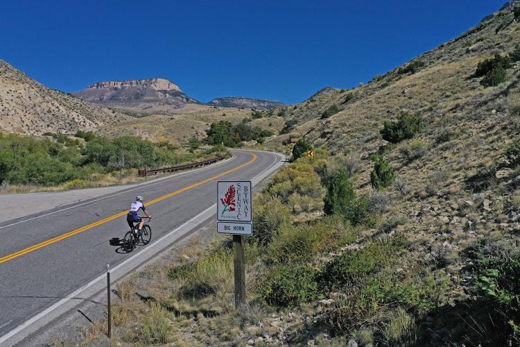
The entire climb is on State Route 14 (this is far less busy than Alternate Route 14).
The rock and geological formations along this route are superb (comparable to Mt. Lemmon, Arizona), including multi-colored interbedded mesas, hoodoos, and palisades. This is a geologist’s (and cyclist’s) dream!
THE CANYON - START TO MILE 1.5
![]()
This ride has one of the most rugged and distinctive beginnings to a Top 100 U.S. Climb. We begin the climb on Black Mountain Road just east of Shell, Wyoming, and soon enter a narrow and picturesque canyon that borders our bike climb for the first 1 ½ miles.
![]()
Aerial view of the first half of the canyon segment.
![]()
There are several geological markers along the climb.
![]()
Aerial photos of the beginning (left) and end (right) of the narrow canyon we ride through to begin the climb.
This climb into the Bighorn Mountains, Wyoming is #58 on the Top 100 U.S. climbs list, and is just 65 miles from #21 (Highway 14 Alt Route, Wyoming), and 137 miles from the start of #94 (Beartooth Pass, Montana). The route follows Shell Creek (to our left as we climb) for the first two miles until we part company and climb through two giant switchbacks on up to the summit. TripAdvisor reports give the area very high marks.
MILE 1.5 TO MILE 11
![]()
We leave the canyon at mile 1.5 and quickly ride up 2 giant hairpins.
![]()
Although out of the canyon at mile 1.5, we are bordered by high bluffs for the next 9.5 miles.
The climb is quite remote and barely known to the cycling world (129 Strava members had ridden the segment as of September, 2023), but that is just another factor contributing to the unique nature of this adventurous climb. Legs permitting, you may consider doing both Highway 14 Alternate Route and Granite Pass (which is on the actual [non-alternate?] Highway 14) - this is a punishing ride at 123 miles and 14,000’ of climbing and no facilities (except the Bear Lodge Resort, if it is open - check in advance).
![]()
Viewpoint at mile 2.7
![]()
Viewpoint at mile 4.7
, Wyoming")
Cycling Wyoming is a great way to experience a lot of wildlife.
![]()
Eyes peeled for the hoodoo formations bordering Shell Creek at mile 7.4
![]()
Scenes along the middle segment of the climb.
MILES 11 TO FINISH
![]()
There is a smattering of fall colors during season along the second half of the climb.
, Wyoming")
Final push to the top.
![]()
There is a summit sign to the right at the end of the climb.
![]()
Views at the summit.
Roadway Surface and Traffic Report: The roadway is in excellent condition, but has no shoulder for most of its length. However, we felt this to be a safe route with minimal traffic throughout..
PJAMM Cycling contributor David Stauffer of Ithaca, New York wrote an excellent and very informative blog about his climbs in this area. His description of Granite Pass West:
Starting steeply in a scenic canyon, you gradually climb out onto the open hills at higher elevation. There is a bathroom/parking lot at 10 miles that also has a drinking fountain. The top of the climb is somewhat shallower but grades are fairly consistent throughout. Quite a slog at 18 miles in length. As you leave the canyon the surrounding mountains tower above, providing the best views.
PJAMM contributor Edward Meyer of Norwich, Vermont provides an exceptional summary of this climb:
Shell Canyon/Granite Pass offers cyclists a Bighorn Mountain climb on a lightly used and well paved road. The climb starts in a narrow canyon just after crossing over Shell Creek. Large cliffs of sedimentary rock tower over the narrow canyon and the grade starts at only a few percent. After 1 mile of climbing the canyon begins to open up and the climbing steadily steepens to an average of about 6% as you approach a pair of hairpin turns. On and above the hairpins you start to get a great overview of Shell Creek, which sits below in a narrow gorge that has cut into 2.8 Ga rocks that underlie the Bighorn Mountains. At three miles into the climb you will pass the parking lot for the Shell Bench mountain bike trail and a pit toilet. The climb continues up highway 14 as it winds around giant landslides. At 6.7 miles you encounter the Shell Falls visitor center. In the summer months there is potable water and flush toilet access and a short path down to Shell Falls. There are no formal water services above this point. Just after the visitor center, the highway crosses over Shell Creek again and continues to climb into a more open valley. A new truck runaway ramp sits to the climbers left. From here you climb to mile 11 where you encounter another set of sharp turns and Forest Service Road 17 which provides access to a pit toilet just off the highway (A few miles further down Forest Service Road 17 is access to a Forest service campground and ranger station). Continue up highway 14. Grazing cows are common on the road so keep a heads up. You will pass the closed Antelope Butte ski area on your right at around 15 miles. From there it's a short climb to the top of Granite Pass.