
38.9
PDI
24.4 mi
DISTANCE
7,092 ft
GAINED
5.2 %
AVG. GRADE
FULL CLIMB STATS
Page Contributor(s): Dan Razum, Campbell, California
INTRO
"Mineral King is a very long, twisty and scenic climb up into the high country along one of the most narrow and tortuous roads the author has ever seen. It is along a very variable grade as well. It has steep sections near the start but soon settles down as the route heads inland along a ridge and then enters a scenic canyon. Around 6.5 miles in you cross a bridge over a small river and you remain on this side of the drainage for the remainder of the ascent. Here the road gets very narrow as it follows the ridge line uphill through thick brush. There are multiple tight and blind turns along the way on this stretch along with a few double digit grade sections (and a few descents and cattle guards)..." (This quote is presented with the approval of John Summerson, from his book, The Complete Guide to Climbing (by Bike) in California p. 158.)
PLAN YOUR ROUTE
While the average grade of 5.1% for this 24 mile climb is impressive, the magnitude of this ride is much more appreciated when we remove descents from the gradient formula which increases the average grade to a rugged 6.5%. 3.6 miles (14.9%) of the climb is at an average grade of 10-15%, 0.4 miles (1.5%) are at 15-20%, and a brief portion of the climb is at ≥20%. The steepest quarter-mile on the climb is 13.7%, and steepest mile is 12.1%.
See more details and tools regarding this climb's grade via the “Profile Tool” button.
Roadway: As of 2019 much of the roadway was in poor condition. The road is very narrow, oftentimes barely two lanes and there is no center stripe, although in this remote area, none is needed.
Traffic: Minimal.
Parking: Park at or near the start of the climb - Map; Street View.
Fee: Paying your National Park entrance fee is on the honor system at mile 10.3.
Bike: Although the road is very rough and bumpy, we have done it both times without trouble on a road bike with 25mm (28mm on the second round) tires. The last few miles past Silver City are dirt and gravel but manageable on road bike.
Provisions: None until the end and boy, then some! Be sure to stop at the Silver City Store which has a grill and bakery.
Before heading out on any cycling adventure check out our Things to Bring on a Cycling Trip and use our interactive check list to ensure you don't forget anything.
We stayed in Visalia on the two trips we took to this area to do the Kings Canyon/Sequoia NP climbs (PJAMM climb pages: Kings Canyon National Park; Sequoia National Park). However, if you are just there for Mineral King and/or Highway 198 (General's Highway) consider staying in Three Rivers near the start of each of those climbs. Both Visalia and Three Rivers have options for vacation rentals as well.
From Three Rivers, it is just 5 miles to the entrance to Sequoia National Park. If you ride General's Highway (or just wish to visit) be sure to visit (a) General Sherman Tree (biggest tree by volume in the world; Google Map + Review), (b) Giant Forest Museum (Google Map + Reviews) and (c) do the short hike to Moro Rock (Google Map + Reviews).
If you hike - AllTrails Best Hikes in Sequoia National Park.
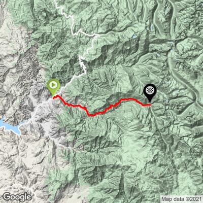
ROUTE MAP
MEMBER RATING
CURRENT WEATHER
PJAMM TRIPS ADVENTURE STARTER BUNDLES
Check out PJAMM Adventure's prepackaged (self-guided) cycling trips. They will help you plan, document and conquer your next adventure.
NEARBY CLIMBS (0) RADIAL PROXIMITY
FROM No Climbs Found
MEMBER REVIEWS & COMMENTS
Let us know what you thought of this climb. Signup for our FREE membership to write a review or post a comment.
Already have an account?
LOG IN HERE
whitoriginals
August 27, 2024
Road gets rougher every year. Glad I did it on an MTB
Prescribed burn along the canyon wall opposite the road. Wind blowi.g smoke away so not bad, BUT mineral king road is the default firebreak if the wind should change so there are crews cutti.g and mulching brush along the route.
Oh, yeah, this is the best ride on the planet for climbing purists.
jessemarkman
Rode Mineral King in May 2020. Due to COVID and gate still being closed for winter the road was virtually empty. A few Park vehicles and a car or two going to private cabins.
It's a very long climb and for much of it, you can see where you are heading, far in the distance. Started in Three Rivers at 9 AM; 60 deg. By 10:30 it was well into the 80s and very exposed. Was about 4 hours riding time, not photo stops to reach the top. I carried 2.5 L of water with me to the top as I didn't want to stop. Drank almost all of it and was happy to use my SteriPen and refill with fresh cold mountain stream water.
Descent was quite technical due to the high speed and poor road quality. I am a fast descender but still took almost 1:15 to return to the bottom where it was mid 90s, at least.
Would recommend this ride when the road is closed to traffic as it would be sketchy with frequent cars.
Highly recommended to anyone looking for an adventure and to bag a 7,000' climb.