![]()
Cycling Hwy 198 (General’s Highway): A magnificent bike climb into Sequoia National Park.
This is one of our favorite cycling climbs in California, the US, and the World.
California Top 10 Most Scenic Bike Climb.
Climb summary by PJAMM’s John Johnson.
PJAMM Note: The last ⅓ of this ride is one of the most extraordinary segments of roadway in the world.
![]()
![]()
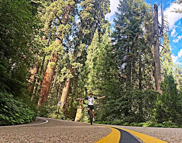
One of the all-time best photo opps at mile 16.2
It’s to your left on a left turning hairpin - Don’t miss it!
Highway 198 is #27 on the Top 100 US Climb List and is just two miles from #16 (Mineral King Road), and 24 miles from #47 (Highway 21-245-180-198). You ride into Sequoia and Kings Canyon National Parks within the first mile of the climb starting you off with a shallow entry (3.1% average grade for the first four miles). The remaining 13 miles average 6.2%, gaining 4,435' over that distance.
![]()
We enter Sequoia and Kings Canyon National Parks at .4 mile of the bike climb.
Entrance fee is $15 for bikes as of 2019 ($10 fee on photo is 2015 price)
Giant Forest Museum is at mile 17.5
We took on this climb (and foolishly Mineral King on the same day) on July 7, 2015. Along the way, we ran into (well, came up on) long time Highway 198 climber Bill Pooley. Bill has ridden this climb over 50 times and even counted the turns and hairpins manually (i.e., by counting them in person, pre Google Maps, of course): 24 hairpins and 240 turns. This huge amount of turns makes for an extraordinary descent, we would even go as far as to say that this was one of the most fun descents we’ve ever encountered: a great road, not too steep, not too shallow, juuuuuust right!
![]()
Half a mile from the start.
![]()
2.7 miles in.
![]()
Tunnel Log
Accessed by turning right on Crescent Meadow Rd at mile 17(2.8 miles round trip)
Google Map + Reviews
![]()
This one crossed our path near the General Sherman Tree.
The ascent also offers two extremely unique opportunities along the way: (1) unparalleled (and we don’t use that term loosely here) views down at more switchbacks than you will see from any vantage point in the U.S. that we are aware of, beating Palomar, Pikes Peak, Onion Valley, Haleakala, etc., and (2) the largest tree by volume in the world, the General Sherman. The tree can be observed by riding 0.7 miles from the finish of our climb to the General Sherman Tree (most of the road is paved and then you ride/walk your bike down the footpath to the tree (about 0.2 miles) - it’s well worth the detour.
![]()
The hairpins on this climb rival the best in the US (e.g., Beartooth Pass, Horseshoe Meadows and Palomar Mountain).
![IMG_1701.JPG]()
OTHER CLIMBS IN
KINGS CANYON AND SEQUOIA NATIONAL PARKS
![]()
Photo - from upper left clockwise:
Bear Creek; Mineral King; Hwy 198; Whitaker Forest;
THINGS TO DO AND SEE IN SEQUOIA NATIONAL PARK:
CYCLING THE GIANT FOREST
![]()
Enter the Giant Forest at mile 14.7.
Ultra Climber Joey Galloway writes of this climb:
The Hwy 198 climb from Three Rivers to Giant Forest Museum is a stout 17 mile HC climb summiting at nearly 7,000 ft. The official start of the climb is the Pumpkin Hollow Bridge at the Gateway Restaurant, about 1/3 mile before the Sequoia Nat'l Park entrance at Ash Mountain. The first few miles is rolling terrain following the Kaweah River where oak trees and dry grass abound. Upon reaching Hospital Rock the rest of the climb is all uphill and averages around 7% for the last 10 miles. There are many switchbacks and the views are reminiscent of the French Alps, spectacular. Looming above you is Morro Rock, a solid granite dome. A quick stop at Amphitheater Point is a must as the views are simply stunning. Look to the west and see the San Joaquin Valley. Look to the east and south to see craggy mountain tops. And of course Morro Rock looms large. From Amphitheater Point you slowly enter alpine territory as pine trees appear. Skirting around Deer Ridge you finally enter Giant Forest. The road is now shaded and the temperature falls dramatically. Upon entering Giant Forest you will ride by the biggest trees, hence, the biggest living things in the world, the Giant Sequoias. A nice treat for summiting this magnificent climb.
Roadway Surface and Traffic Report: Traffic is heavy, but travels slowly. The roadway surface is excellent throughout this climb.
GENERAL SHERMAN TREE
LARGEST TREE BY VOLUME IN THE WORLD
At 275’ tall, with a 102.6’ circumference and a 35.5’ diameter, the General Sherman is the largest single-stem tree on Earth. The tree is named for famed Union General William Tecumseh Sherman.
![]()
The entrance for this extraordinary experience is near the end of the climb.
![IMG_3208.JPG]()
![IMG_3209.JPG]()
MORO ROCK
Another point of interest to be aware of is Moro Rock, a large granite dome formation located near the center of the park, which we see in the far distance as we enter the park, but gradually approach and ultimately pass it along our journey.
![]()
Moro Rock
The Moro Rock hike is accessed from Crescent Meadow Road which begins at the Visitor Center 16 miles from the park entrance. The hike itself is ½ mile round trip. There are vast panoramic views of Sequoia National Park and the surround Sierra Nevada Mountain Range from the Moro Rock.
![]()
Moro Rock Viewpoint
Photo: visitsequoia.com
GIANT FOREST MUSEUM
![]()
Mile 17.
![]()
From the National Park Website:
Giant Forest Museum, together with a connecting nature trail system leading to Round Meadow and vicinity, provides a basic introduction to the primary features of Giant Forest including its giant sequoias, meadows, and human history. The renovation of the historic Giant Forest market building, which is listed on the National Register of Historic Places, began in 1999, and conversion to a museum and visitor center was completed in summer 2001. more
![Kaweah River Bridge]()
That’s a wrap!

 We've partnered with Sherpa-Map.com to bring you the best route planning tool. With a PRO Membership you can use this climb as a reference when creating your route.


