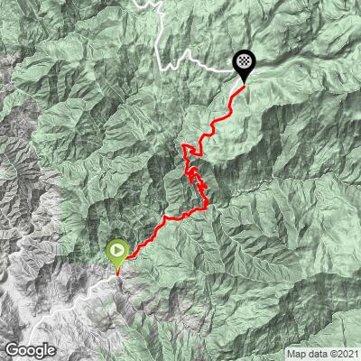
Hwy 198 (General's Highway) Bike Climb - PJAMM Cycling

11.1
FIETS
20.5 mi
DISTANCE
6,113 ft
GAINED
5.5 %
AVG. GRADE

FULL CLIMB STATS

Page Contributor(s): Bruce Hamilton, La Quinta, CA; Stacy Topping, Tacoma, WA; Lisa Irizarry, NY, NY

INTRO

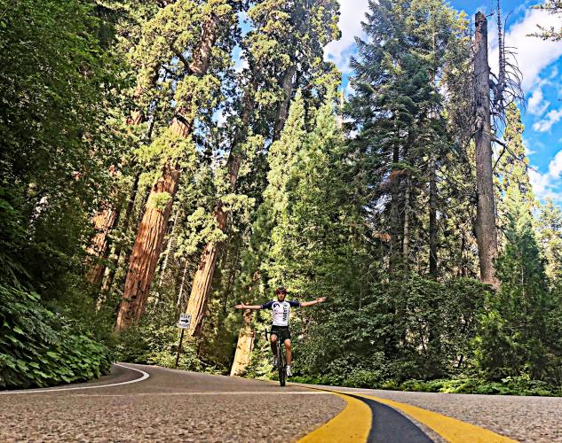
This is the #5 Most Scenic Bike Climb in California and also one of the most difficult in the US at #25.  We enter Sequoia and Kings Canyon National Parks within the first mile of the climb up through a giant set of hairpins and into some of the greatest Giant Sequoia trees in the world. 

Note that Hwy 198 is closed along this segment until early July, 2023 - check Sequoia National Park Current Conditions for status. 


The average grade of this 20 mile climb is 5.5% (6.2% with descent removed).   34% (6.9 miles) of the climb is at 0-5% grade, 47% (9.5 miles) is at 5-10%, and 11% (2.2 miles) is at 10-15% grade.  The steepest quarter-mile is 10.9% and the steepest continuous mile is 8.7%.

Consult the PJAMM "Full Forecast" feature for the time you expect to arrive at the finish to assess what clothing to bring on your ride.
Roadway:  This roadway, like most, if not all, National Park roads, is in excellent shape and safe to ride a bike on.

Traffic:  Depending on the time of year and day, traffic varies from light to heavy, but we have always felt comfortable riding this route. 

Parking:  There is not much parking near the start of the climb until you are in the park.  There is parking on the right 50 yards after entering the park - park here and ride back a half mile to the start of the climb - MapStreet View
Fee to Enter the Park:  To enter on bike is $15 as of 2020. 
Before heading out on any cycling adventure check out our Things to Bring on a Cycling Trip and use our interactive check list to ensure you don't forget anything.
The Sequoia and Kings Canyon National Park area has no shortage of unique vacation homes and mountain cabins.

ROUTE MAP

MEMBER RATING

Difficulty: Strenuous
5
Road
3.7
Traffic
4.7
Scenery

CURRENT WEATHER

PJAMM TRIPS ADVENTURE STARTER BUNDLES

Check out PJAMM Adventure's prepackaged (self-guided) cycling trips. They will help you plan, document and conquer your next adventure.
ALL TRIPS
Browse all of our prepackaged trips and find your next adventure!
Sequoia and Kings Canyon
United States (CA)
15 ROUTES
11 POIs
ROUTE STATS (TOTAL)
281
mi
DISTANCE
77,122
ft
ELEV. GAIN

NEARBY CLIMBS (0) RADIAL PROXIMITY

FROM
No Climbs Found

MEMBER REVIEWS & COMMENTS

Let us know what you thought of this climb. Signup for our FREE membership to write a review or post a comment.
Already have an account?

Oct 27, 2022
rode this on a wednesday starting at 830. was passed by no more than ten cars. still amazed at the number of cars that will come around on a blind curve. where are they thinking they will go if there is a car coming down? they will pull hard to the right and kill me, of course, but i digress. i'm not a pjamm purist, so i would recommend starting this climb from the parking lot immediately after the booth where you enter the park and riding all the way to the baldy summit trailhead (and back). also...when you reach the museum/sentinel tree, be sure to turn right into the parking lot then right again uphill, then down to the moro rock, then out to the end of the road to the meadow. best road/tree ratio in the park. 75 at bottom, 45 at top. bring a change of clothes!
Apr 1, 2022
difficulty: Challenging
scenery: 5
traffic: 3
road: 5
Apr 1, 2022
scenery: 5
traffic: 3
road: 5
I love this climb! I rode this yesterday and there was quite a bit of traffic. Traffic was more amused then anything and people were cheering me on as I rode to the top. It was literally leap frog the whole way up/down because people were pulling over to take photos of the flowers and the views. This was a Wednesday and I left later than I should. There was some snow in the hiking trails but none on the road.
May 9, 2021
difficulty: Challenging
scenery: 4
traffic: 3
road: 5
May 9, 2021
scenery: 4
traffic: 3
road: 5
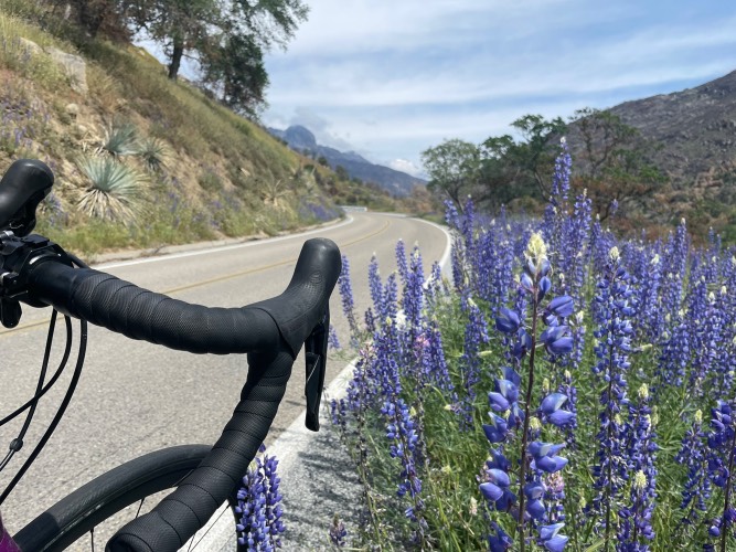
Great climb! The really nice views of the sequoias don’t come until the last 3 miles or so but the climb to get there has a very consistent grade which makes the climb super enjoyable. The steepest section was probably the second to last mile where the grades are 8-11% but besides that the grades are very moderate. The traffic comes in waves as you can go a mile without seeing a car and then ten cars in a row. The cars give you plenty of space as I think they are more annoyed by the slow driver in front of them driving the speed limit (25mph) than worrying about passing cyclists. You should definitely go past the top of the climb as a lot of the views of the massive sequoias continue along General’s Highway as the terrain rolls.
Apr 16, 2021
difficulty: Extreme
scenery: 5
traffic: 5
road: 5
Apr 16, 2021
scenery: 5
traffic: 5
road: 5
Rode late November 2020. Beautiful climb nearly the entire stretch. Rode quality excellent and light traffic on an early weekday. Would expect weekend traffic (even early) to detect from the experience.
ROUTE MAP
PROFILE TOOL
Route Data
S.G. (%)
hide
Segment Data
hide

Climb Profile Not Found
CLIMB SUMMARY

Cycling Hwy 198 (General’s Highway): A magnificent bike climb into Sequoia National Park.

This is one of our favorite cycling climbs in California, the US, and the World.

California Top 10 Most Scenic Bike Climb.

Climb summary by PJAMM’s John Johnson.

PJAMM Note:  The last ⅓ of this ride is one of the most extraordinary segments of roadway in the world.

One of the all-time best photo opps at mile 16.2

It’s to your left on a left turning hairpin - Don’t miss it!

Highway 198 is #27 on the Top 100 US Climb List and is just two miles from #16 (Mineral King Road), and 24 miles from #47 (Highway 21-245-180-198).  You ride into Sequoia and Kings Canyon National Parks within the first mile of the climb starting you off with a shallow entry (3.1% average grade for the first four miles).  The remaining 13 miles average 6.2%, gaining 4,435' over that distance.


We enter Sequoia and Kings Canyon National Parks at .4 mile of the bike climb.

Entrance fee is $15 for bikes as of 2019 ($10 fee on photo is 2015 price)

Giant Forest Museum is at mile 17.5

We took on this climb (and foolishly Mineral King on the same day) on July 7, 2015.  Along the way, we ran into (well, came up on) long time Highway 198 climber Bill Pooley.  Bill has ridden this climb over 50 times and even counted the turns and hairpins manually (i.e., by counting them in person, pre Google Maps, of course): 24 hairpins and 240 turns.  This huge amount of turns makes for an extraordinary descent, we would even go as far as to say that this was one of the most fun descents we’ve ever encountered: a great road, not too steep, not too shallow, juuuuuust right!

Half a mile from the start.

2.7 miles in.

Tunnel Log

Accessed by turning right on Crescent Meadow Rd at mile 17(2.8 miles round trip)

Google Map + Reviews

This one crossed our path near the General Sherman Tree.

The ascent also offers two extremely unique opportunities along the way:  (1) unparalleled (and we don’t use that term loosely here) views down at more switchbacks than you will see from any vantage point in the U.S. that we are aware of, beating Palomar, Pikes Peak, Onion Valley, Haleakala, etc., and (2) the largest tree by volume in the world,  the General Sherman. The tree can be observed by riding  0.7 miles from the finish of our climb to the General Sherman Tree (most of the road is paved and then you ride/walk your bike down the footpath to the tree (about 0.2 miles) - it’s well worth the detour.  


The hairpins on this climb rival the best in the US (e.g., Beartooth Pass, Horseshoe Meadows and Palomar Mountain).

 IMG_1701.JPG

OTHER CLIMBS IN

KINGS CANYON AND SEQUOIA NATIONAL PARKS

Photo - from upper left clockwise:

Bear Creek; Mineral King; Hwy 198; Whitaker Forest; 

THINGS TO DO AND SEE IN SEQUOIA NATIONAL PARK:

CYCLING THE GIANT FOREST

Enter the Giant Forest at mile 14.7.

Ultra Climber Joey Galloway writes of this climb:

The Hwy 198 climb from Three Rivers to Giant Forest Museum is a stout 17 mile HC climb summiting at nearly 7,000 ft.  The official start of the climb is the Pumpkin Hollow Bridge at the Gateway Restaurant, about 1/3 mile before the Sequoia Nat'l Park entrance at Ash Mountain.  The first few miles is rolling terrain following the Kaweah River where oak trees and dry grass abound.  Upon reaching Hospital Rock the rest of the climb is all uphill and averages around 7% for the last 10 miles.  There are many switchbacks and the views are reminiscent of the French Alps, spectacular.  Looming above you is Morro Rock, a solid granite dome.  A quick stop at Amphitheater Point is a must as the views are simply stunning.  Look to the west and see the San Joaquin Valley.  Look to the east and south to see craggy mountain tops.  And of course Morro Rock looms large.  From Amphitheater Point you slowly enter alpine territory as pine trees appear.  Skirting around Deer Ridge you finally enter Giant Forest.  The road is now shaded and the temperature falls dramatically.  Upon entering Giant Forest you will ride by the biggest trees, hence, the biggest living things in the world, the Giant Sequoias.  A nice treat for summiting this magnificent climb.

Roadway Surface and Traffic Report:  Traffic is heavy, but travels slowly.  The roadway surface is excellent throughout this climb.

GENERAL SHERMAN TREE

LARGEST TREE BY VOLUME IN THE WORLD

At 275’ tall, with a 102.6’ circumference and a 35.5’ diameter, the General Sherman is the largest single-stem tree on Earth.  The tree is named for famed Union General William Tecumseh Sherman.

The entrance for this extraordinary experience is near the end of the climb.

IMG_3208.JPG

IMG_3209.JPG

MORO ROCK


Another point of interest to be aware of is Moro Rock, a large granite dome  formation located near the center of the park, which we see in the far distance as we enter the park, but gradually approach and ultimately pass it along our journey.

Moro Rock

The Moro Rock hike is accessed from Crescent Meadow Road which begins at the Visitor Center 16 miles from the park entrance.  The hike itself is ½ mile round trip.  There are vast panoramic views of Sequoia National Park and the surround Sierra Nevada Mountain Range from the Moro Rock.

Moro Rock Viewpoint

Photo:  visitsequoia.com

GIANT FOREST MUSEUM

Mile 17.

From the National Park Website:

Giant Forest Museum, together with a connecting nature trail system leading to Round Meadow and vicinity, provides a basic introduction to the primary features of Giant Forest including its giant sequoias, meadows, and human history. The renovation of the historic Giant Forest market building, which is listed on the National Register of Historic Places, began in 1999, and conversion to a museum and visitor center was completed in summer 2001.  more

That’s a wrap!

Access to full Climb Summary requires a PJAMM Cycling PRO Membership!

It takes less than a minute to sign up & with your PRO membership you can:
  • Rate climbs, post comments and share your experiences on any of our climb pages
  • Create bucket lists of climbs & mark the dates you complete them
  • Weather data for all climbs - Start & Finish
  • Upload photos to your member page to customize your PJAMM Cycling experience
  • Utilize all of our interactive tools - Profile & Routes in Area
  • Download climb route .gpx files
LEARN MORE
SIGN UP

Already have an account? LOG IN HERE