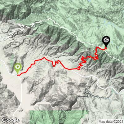
28.2
PDI
12.4 mi
DISTANCE
4,483 ft
GAINED
6.9 %
AVG. GRADE
FULL CLIMB STATS
INTRO
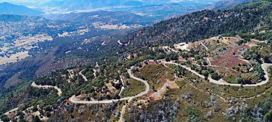
The Palomar Mountain Bike Climb is the longest and second most difficult (after Nate Harrison Grade a mile away) bike climb in San Diego County. This is also the most popular climb by bike in California's cycling popular San Diego County. Some of the points and details of interest on Palomar are: (1) 18 continuous radius hairpins - this is our favorite set of hairpins in the US, (2) Mothers Kitchen restaurant at the top - get the apple pie!, and (3) the Palomar Observatory five miles past the climb finish.
PLAN YOUR ROUTE
Mount Palomar is a remarkably steady climb, rarely leaving the 5-8% gradient range. Testament to the continuous smooth grade is a steepest quarter mile of only 8.6%, and a steepest mile of 8.1%. Corroborating that data point is our gradient bar graph (found under "Profile Tool") that shows 82% (10.1 miles) of the climb is in the 5-10% gradient range. Only 4% of the climb is at 10% or greater (almost all of that never exceeding 10%).
See more details and tools regarding this climb's grade via the “Profile Tool” button.
Roadway: This is an impeccable roadway from top to bottom. The continuous radius hairpins are a delight to descend.
Traffic: The first 5 miles are on busy Highway 76. After turning onto South Grade Road, vehicular traffic is mild and no cause for concern. However, beware of motorcyclists on this popular windy roadway - it attracts adrenalin junkies riding race bikes wearing body armor - be particularly careful on the right hairpins as this is where you are most vulnerable to a racer hugging the inside of the curve.
Parking: Try the market or Jilberto's Taco Shop or the market, both at the start of the climb - ask permission (Map; Street View). Otherwise, on weekends park at the Municipal Water District parking lot j100 yards southeast of start (Map; Street View)
Gear: As with any climb to significantly higher altitude, be sure to check the PJAMM weather tool on this site for the weather forecast at the climb finish.
Provisions: This climb is more like Alpe d'Huez than you would think - well . . . kinda . . . There is Jilbertos Taco Shop (C grade, but an A when you are starving after you descend) at the start, and a market (map). However, you should not be hungry when you finish because you MUST eat at Mother's Kitchen at the junction just down from the finish (7/10's of a mile)- we recommend the apple pie with vanilla ice cream! See more details in the full climb summary. Map, Street View. The Palomar General Store is next to Mother's Kitchen and has some food and drinks.
Before heading out on any cycling adventure check out our Things to Bring on a Cycling Trip and use our interactive check list to ensure you don't forget anything.
Also consider visiting the Palomar Observatory five miles north of the General Store and Mother's Kitchen (Map; Street View; Google Map + Reviews). There is also a gift shop at the Observatory (Google Map + Reviews).
Also see our San Diego County and Southern California climb pages for more great bike climbs in the region.
ROUTE MAP
MEMBER RATING
CURRENT WEATHER
PJAMM TRIPS ADVENTURE STARTER BUNDLES
Check out PJAMM Adventure's prepackaged (self-guided) cycling trips. They will help you plan, document and conquer your next adventure.
NEARBY CLIMBS (0) RADIAL PROXIMITY
FROM No Climbs Found
MEMBER REVIEWS & COMMENTS
Let us know what you thought of this climb. Signup for our FREE membership to write a review or post a comment.
Already have an account?
LOG IN HERE
neilvet
Did the climb late June of 2026 (hot!) and stayed at the Harrah's Resort in Rincon. The ride starts gradually uphill almost immediately after leaving the hotel and reaches the junction of highway 76 in 1.5 miles. It's then a steady climb of about 5 miles and 1500' to S Grade Rd. The traffic was moderate on 76 with a shoulder that ranges from good to non-existent but wasn't a problem. Once on S Grade the traffic is lighter and the climb is steady for the next 7 miles and 2600' to the general store. I made the mistake of not bringing bug spray. The mosquitos were relentless. There was an artesian spring about a mile before the general store, but there was no water. From the store, it's another 5 miles to the observatory. There's an initial 2 mile descent, then a 3 mile climb with about 800' of elevation gain (worth doing to see the observatory). My return was on E Grade Rd to 76 for a total of 50 miles and 6000' of climbing. There were nice views from the top of E Grade Rd.
golmstead
This is what I ride when I want to check my climbing fitness. I know that if I can feel strong on this I can do okay on other climbs. It's a great benchmark ride. The first part, up Hwy 76 is ok. There's just a lot of commercial truck traffic and they generally give you space, but not always. After you turn on to South Grade Road, and off 76, it's a different story. Much more relaxed and quiet. On weekends there are motorcycle clubs that ride up South Grade, but the unspoken rule is that bicycles stay to the right of the fog line and motorcycles stay to the left, and it all works out. You can hear the motorcycles coming so there's always time to move to the right.
Dtour
Nice steady climb.
You do not have to park at Jilbertos and battle it out on Hwy 76. There is a dirt... space at the intersection of 76 and S6.
Be cautious of cattle guards with big ol gaps. I think there were three.
mass_biker

Had a chance to hit Palomar recently while visiting SoCal. I parked at the Harrah’s Rincon and headed up South Grade. It was beautiful and temperate (high 50s, light clouds) at the base. The ride up 76 was great with relatively light traffic as it was a weekday. When I turned onto the South Grade switchbacks, traffic all but disappeared. However, as I climbed, the temperatures dropped rapidly, and the wind picked up. By the time I got to Mother’s it was in the 30s, blowing hard, and very overcast - I added a few more miles to the Park Entrance after putting on all the extra clothing I had (gaiter, vest, light long finger gloves) and headed back down. Between the shivering and the wind, I wasn’t railing the descent by any means - I just wanted to stay upright! I could have used warmer gloves and another layer up top - something I’ll have to plan for future Spring trips. This climb is a must do. My 36x28 was fine for this ride, by the way, as nothing was super steep; just long.
Kgn88
Completed this climb 2 times while living in SoCal for a year. Definitely the toughest climb I've ever done. I started at the taco shop at the bottom both times. The first few miles are on a fairly busy road, but the shoulder is fair, and most cars seem to know that it is a popular cyclist route. Once you make the left hand turn to head up the actual mountain, traffic calms down and then you can look forward to the hairpins and the views, which are WOW!! Amazing sights the higher you get. Beautiful mountains all around. Moms at the top is a must stop. Already planning a return trip this year! Do this climb if you have the chance.
Daddyshome803
Can this climb be done in January, or is it snow-covered towards the top? Thanks.
jjcgilbert
Climbed for first time 7/27/2023. Left at 8am during the 2023 heat wave. Good amount of shade for most of climb for SoCal so overheating wasn't a huge concern. It's a steady climb at a steady grade. On a Thursday not much traffic and only one car drifting down that concerned me. I cycle a lot but not pro so the semi-compact and 11-30 cassette worked fine but I coulda used a bit bigger in the back for some rest in the heat. Road conditions were good but a lot of broken glass here and there.
jjcgilbert
.
Jghanaie


I did this did this midweek and left from Harrah's Casino. It was annoying traffic at the beginning with aggressive drivers but then mellowed out.
Tinypip
The road for the first 5 miles isn't ideal, but the shoulder is usually adequate, and on the narrow parts, traffic is going a bit slower. Once you make the turn, traffic is much lighter, and it's just a fantastic climb. Grade is extremely steady, and you'll be amazed at how fast the elevation flies by. The burritos at the base are a wonderful reward. We descended in the rain, but the gradual grade kept it from feeling too dangerous.
carbon23
Great climb. I parked at Jilberto's across the street which seemed to be fine, and the burrito I had from Jilberto's was delicious. The first 5 miles has an off and on shoulder which makes it better than I thought it was going to be. The last 7 miles are lovely, although I did encounter some racing motorcycles which are loud and annoying. Make sure to figure out where to go once you hit the top of South Grade because there is no service up there. The descent is fantastic, although there was some gravel on the road and the road can be pretty cracked. Make sure to bring plenty of water on a Summer day, as it was sweltering on the bike up.