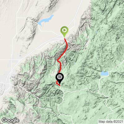
28
PDI
14 mi
DISTANCE
4,348 ft
GAINED
5.9 %
AVG. GRADE
FULL CLIMB STATS
Page Contributor(s): Ron Cushing, Cedar City, Utah, USA
INTRO
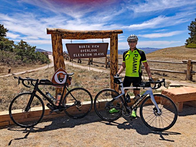
"The north side of Route 143 is a solid hill and a contender for the most difficult ascent in southern Utah. A shallow start from Parowan, the first nine miles are along a slowly increasing grade and with fairly straight routing within a scenic canyon. A steep section through tight hairpin turns then breaks up the rhythm of the ascent as it abruptly carries you further up the mountain. On top of the S curve the grade then eases but not by much and at mile 11 you pass through the small town of Brian Head, UT over continued stout grade. Leaving the town the grade increases again before easing just before the signed and scenic summit within an alpine setting above 10,000 feet." (This quote is presented with the approval of John Summerson, from his book, 50 Climbs (by Bike) in Utah, pg. 142.)
PLAN YOUR ROUTE
It is the 6% average grade to 10,000' altitude (30% less oxygen than at sea level) the propels this climb into the US Top 50. 43% (six miles) are in the 0-5% gradient range, 44% (6.2 miles) are at 5-10%, 1.5 miles (11%) are at 10-15%, and 0.1 mile is at 15-20%. The steepest quarter-mile is 13.5% and steepest continuous mile 11.6%.
See more details and tools regarding this climb's grade via the “Profile Tool” button.
Roadway: Excellent condition as of 2019.
Traffic: Mild.
Parking: At Lions Park on Third E Street a block to the west of our start - Map; Street View.
You are riding to high altitude so be sure to consult the PJAMM "Full Forecast" feature for the time you expect to arrive at the finish to assess what clothing to bring on your ride.
Before heading out on any cycling adventure check out our Things to Bring on a Cycling Trip and use our interactive check list to ensure you don't forget anything.
Consider the out-and-back that includes Highway 143 East which is 92 miles and 9,400' of climbing - Map.
Also consider climbs nearby such as Cedar and Right Hand Canyon Roads and Cedar Canyon (20 miles) and Kolob Canyon Road (39 miles).
You can stay in Parowan, where the climb begins. There are also many options for house rentals in the area.
ROUTE MAP
MEMBER RATING
CURRENT WEATHER
PJAMM TRIPS ADVENTURE STARTER BUNDLES
Check out PJAMM Adventure's prepackaged (self-guided) cycling trips. They will help you plan, document and conquer your next adventure.
NEARBY CLIMBS (0) RADIAL PROXIMITY
FROM No Climbs Found
MEMBER REVIEWS & COMMENTS
Let us know what you thought of this climb. Signup for our FREE membership to write a review or post a comment.
Already have an account?
LOG IN HERE
Chaddad
If you do this early in the morning, you'll have a headwind for a few miles at the beginning. Don't be in a hurry because around 8,000 feet the road tips up and is a legbreaker for about 20-30 minutes (1000 feet in two miles) until you get a break at Brianhead. After the ski resort there is another solid mile of 8 percent above 9,000 feet before it eases a bit up to the top. If you ride a few more miles you'll hit the high point of the road around 10,400. Make sure you take the first right on top to the view area, which is incredible.
jsummers
A big climb, this one has almost everything as it begins as mild but eventually turns difficult before easing again towards the summit. The classic stretch is an S curve with double digit grade that begins about 10 miles in. You then ride through a small town as well before ending at high altitude.