35.3
PDI
28.8 mi
DISTANCE
7,028 ft
GAINED
4.2 %
AVG. GRADE
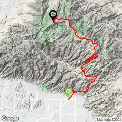
FULL CLIMB STATS
INTRO
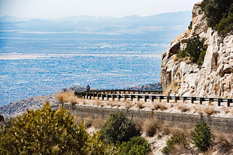
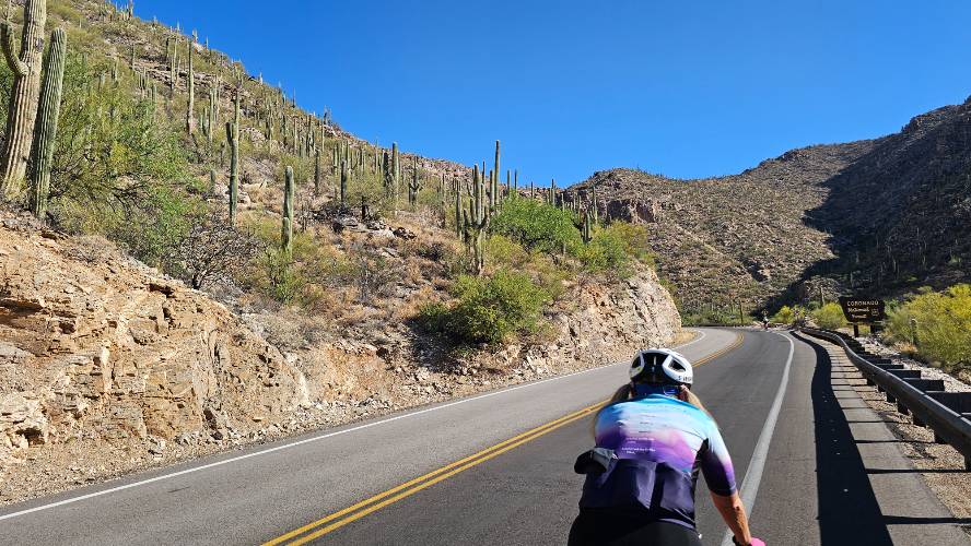
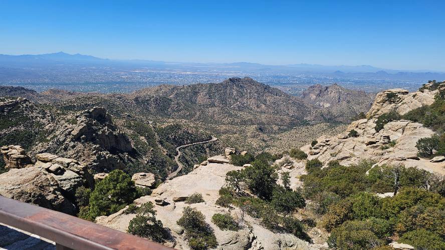
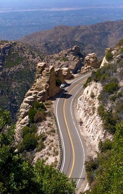
Mt. Lemmon is the longest bike climb and second most challenging in Arizona (after Mt. Graham). This is also one of the most, if not the most, popular road bike climb in the US. Unless you ride it in a snow storm or heat wave (though that's relative for AZ), you'll always encounter many cyclists along the climb. Some of the fun and unique points of interest on this bike climb are: (1) thousands of saguaro cactus during the first miles of the climb, (2) amazing hoodoo formations, (3) spectacular views at Windy Point at mile 14.7, (4) observatory buildings at the top, and (5) the Cookie Cabin in Summerhaven just off the main climb route.
PLAN YOUR ROUTE
But for two significant exceptions, Mt. Lemmon has a generally steady 4-6% average grade. The two exceptions are: (a) 8.1% grade for the last 2.6 miles of the climb and (b) a 2.1 mile -4.2% descent beginning at mile 21.2 and the 0.8 miles -3.3% descent from mile 24.7 down to the right turn to begin the climb up Ski Run Road to the finish. Removing the descents from the equation raises the 4.2% average to 6.8% -- a very significant and difficult average grade for a 25 mile bike climb. 31.5% (9.1 miles) of the climb is at grade 0-5% and 51% (14.8 miles) is at 5-10%. The steepest quarter mile is 10.5% and steepest mile 9.1%.
See more details and tools regarding this climb's grade via the “Profile Tool” button above.
Roadway: This is a pristine roadway from top to bottom.
Traffic: Although the roadway is through a rural area to a dead end, there is moderate but safely moving traffic throughout the climb.
Parking: There are many locations to park on side roads near the start. We've parked at the northeastern corner of E Catalina Hwy and N. Melpomene Way just a block southwest of the start (Map; Street View) and also at our favorite location to stay for the climb - Jeremiah Inn (Map) a half mile from climb start. Another popular place to park is the Le Buzz parking lot 4.5 miles from climb start (Map; Street View).
Provisions: There are no spots for food along the climb, although there is water at the Palisades VC mile 20.5 (Google Map + Reviews); be sure to try the Cookie Cabin in Summerhaven 4/10's of a mile past the turn off to E Ski Run Road (Map; Street View; Google Map + Reviews) - best giant cookies in the world! Also a great place to eat is the Iron Door at the ski resort near the finish - Street View; Google Map + Reviews.
Weather: We have finished twice in the snow on Mt. Lemmon - both times during Spring Training trips in March. Be sure to check the PJAMM weather forecast for the climb finish to assist you in choosing what gear to bring with you. Since you are starting in the desert at 2,700' and finishing over 9,000' in an alpine mountain setting, the temperature can drop 30-40 degrees from the bottom of the climb to the top.
Before heading out on any cycling adventure check out our Things to Bring on a Cycling Trip and use our interactive check list to ensure you don't forget anything.
Booking your travels through one of these links helps us continue to bring you awesome info on climbing and cycling. Thank you!
For you baseball fans, Scottsdale is just a long fly ball away - for example, since we are Giants fans, its 2 hours to the ball park - Route Map.
ROUTE MAP
MEMBER RATING
CURRENT WEATHER
PJAMM TRIPS ADVENTURE STARTER BUNDLES
Check out PJAMM Adventure's prepackaged (self-guided) cycling trips. They will help you plan, document and conquer your next adventure.
NEARBY CLIMBS (0) RADIAL PROXIMITY
FROM No Climbs Found
MEMBER REVIEWS & COMMENTS
Let us know what you thought of this climb. Signup for our FREE membership to write a review or post a comment.
Already have an account?
LOG IN HERE
SoulMan62
If I could use a .5 in the rating would have given this one a 3.5. But based on the length of the climb I rounded up. The portion up to Summerhaven was not difficult - I rode it in the big ring and don't think I saw grade over 7%. The scenery was incredible, especially at the start and through the hoodoos. The last, steep part of the climb was harder. I had to go around a closed gate to reach almost to the end of the road (which was closed off by gate) but went as far as I could. Unfortunately the Cookie Cabin was closed so I missed out on that part. Will have to ride it again :)
DBlondfield
Rode this for my wife's 60th birthday. Nice climb. No water optons until you get near the top. The cookie at the Cookie Cabin is rediculously huge and expensive however you have to get one. If you are in the area make time for this climb.
msmendis
I rode this to celebrate my 40th birthday. I couldn’t have been happier with that decision. The scenery and the change in climate was my favorite part. The grade was perfect for getting in the zone. The cookie cabin lived up to the legend. I just wish I had gone to the actual summit before eating the cookie. That last section was brutal on fatigued legs with sea level lungs. I usually drink a ton of water on the bike. I had a 30 mile ride to the start, so I brought 2 bottles and a camelbak. I’m glad I brought that much water. I’d love to do this ride again!
tomasan
I rode this climb back in late Oct 2023 w/ a good friend of mine (we are both in our late '60s); just getting to post. 1st time riding at this high elevation, wasn't sure what to expect. We heard the temps could drop, and not much for water except at the top. I brought a Camel Bac w/ extra water & clothing; didn't really need either. Temps were between high 80's and mid 60's, wind not too high. Slowest avg MPH I've ever done. We were on a vacation w/ our wives, they met us at the top in a van, we rode w/ them down (not looking forward to a fast decent, cramping hands from braking). Very good climb, highly recommend.
Sebby

Awesome climb!
Webbcorp
Do Graham
Skotscott
Sept 14, 2023
Wonderful climb. Started at the Le Buzz parking lot. This is not a steep, hard climb - steepest section is the last 1½ miles up to the observatory. I rated this climb "strenuous" because of the length - 31 miles from Le Buzz. The road has developed numerous jarring cracks and some very rough spots so be aware on the decent. Water available at the Bigelow parking area on the right side just before the visitors center on the left.
neilvet
Did the ride in late April on a Tuesday. Started from the Safeway at around 7:30 and was at the top by 1:30. Traffic was light and the road was excellent for cycling even though there's not much of a shoulder. I thought the first half up to Windy Point was more difficult than the second mainly because it was hotter. The grade was never particularly steep other than the last couple of miles to the radio towers. Lots of good scenic viewpoints long the way. If I did it again, I would get an earlier start to get to the higher elevations before the heat.
Wiseclam
Mt Lemon is a great climb. It is relentless (little to no break from climbing) but beautiful and the road is relatively smooth (6 out of 10 for me). One word of caution... plan on 20 degrees difference from bottom to top. I started early (April 4 2023) with unseasonably cold temps in the low to mid 50s in Tucson and hit the 30s above 7000 ft. Add heavy winds, getting stronger as I climbed. I carried a lot of gear (e.g., two layers of gloves, shoe covers, heavy jacket) and I wish I had more. Also, I am a heavy consumer of water and I was able too make it with three bottles... consumed one full bottle before I departed and carried two large bottles on the bike. Enjoy!
Theisdc
Road early morning, weather was nice. The climb was beautiful, the views were exceptional. I found the climb challenging yet exhilarating. The cookie cabin is definitely worth a visit. I did Mt. Graham the follow day and I do agree that Graham is a harder climb. Both rides are exceptional but I don't think Graham gets the love it deserves. I was the only cyclist on Graham that day. I found Graham to be a more satisfactory ride. It you have the time , Graham won't disappoint.
Laurapyott
What a great ride! Wonderful scenery. Manageable grade. I agree with all of the previous comments; I just wanted to add one thing. There are lots of speedy cyclists on this route. They stink at announcing when they pass you. If you're a casual rider who wants to stop and take pics, be careful of speedy cyclists!
bike-ra
We did this climb in early April the day after Mt. Graham (see my review). Yes it is a must-do but for various reasons I was not mesmerized by it vs. Mt. Graham and Onion Valley Rd. (we did the latter a week later). Maybe doing this right after Mt. Graham was a bad idea (I felt physically fine but perhaps my brain was still saturated by the magnificence of Mt. Graham?). I found the scenery unique and ever-interesting but not majestic. On the plus side it seems easier than the stats would indicate due to the grade, ever-changing scenery, and the camaraderie of the stream of cyclists you can chat with, though the length does eventually turn it into a grind if you let the challenge alone get to you. We also had some horrific 20mph+ winds right out of the gate which may have been the real reason why this review sounds a bit “grouchyâ€. Ignore this grinch and do this ride.
BlairIan
Rode the entire way to the top on Dec 1st 2021. Tough tough ride, but well worth it. Climbed through several eco zones from desert through pine forest. Traffic was light and considerate. Water at Mt. Biglow trail head parking lot. Visitor center was not open when I passed. Be sure to get a cookie at the cookie shack, part of the tradition.
Forza
I flew from CT to AZ this past April 2021 just to climb Mt. Lemmon. It does not disappoint. A very manageble 28 mile climb to the observatory, and never too steep but for the last mile or two. Several safe places to stop and rest or take pics along the way up. You start surrounded by cactus, and by the time you approach the upper half and above it turns to mountain conifer trees. Even got a bit of snow on the side toward top. Recommended climb for sure.
sam.lionman
Awesome pic!!
coralsnake
Its a long climb but the grade is not difficult. Its a lot of fun though. Amazing Arizona views and there were a ton of cyclists out (March 2020). Fun descent too.
gsfisher
Rode from Le Buzz to Summerhaven on May 14, 2021. This was my second climb on Mt. Lemmon, the last one being in May 2019. Epic ride. Stunning scenery. You start in a forest of saguaro cactus and climb to an alpine meadow. In between are incredible hoodoo formations. Just went with 50/34 compact and that worked fine for me, but I was just spinning my way to the top and not pushing it hard. Oxygen concentration in the air we breathe drops from 19% at 2,500 (at the base) to 15.4% at 8,000 feet. It was hot when I rode, 25 degrees hotter than the same time period in May 2019. Some rest facilities were closed, I think because of the pandemic? Saw many terrific road bikers on the way up, all of whom easily passed me and many of whom were much older. Inspiring. And humbling. Stopped for a slice of peach pie in Summerhaven. Hope to ride again next year.
mlag92
I climbed Mt. Lemmon for the first time on 5/1/21. The climb and the scenery as awesome as advertised, nothing short of breathtaking. The forecast called for upper 90s heat from midday on, so I left from the Le Buzz parking lot at just after 6 AM to make sure I was at a higher elevation by them time it started to get really hot. That strategy worked really well and made for a very pleasant experience. The grade from the beginning on was very constant. I rented a road bike from "Tucson Bike Rentals" that had a 32t cassette which I found to be perfect.
THIS CLIMB PAGE MENTIONS THAT THE PALISADE VISITOR CENTER IS OPEN 7 DAYS A WEEK, BUT IT WAS CLOSED ON 5/1/21 WHEN I WENT. I had planned on refilling my water bottles here, but couldn't as a result. It turned out fine since I brought a 3rd bottle. Maybe call ahead to see if they are open or not to plan accordingly.
The sky observatory was not open, but was visible on 5/1/21
Traffic was light on the way up, but heavy coming down.
BlairIan
The constant water source is not at the visitor center but just a bit below it at the Mt. Bigalow trail head parking lot. Facet is right in front of the toilets.
SpeedyBlueBiker
Rode up Mt. Lemmon on Wednesday, 27 April 2021. The weather forecast wasn't the best. Clouds and 49 degrees at the top. Left the Safeway parking lot at 10:30am and it was 55 degrees. Climb is long and just keeps going. It was quite windy out. We had crew support as one of our newer riders wasn't really fit to take on the whole mountain so just rode part way and then returned. At the 6000ft level it was all clouds and the temperature was dropping. At 7000ft we got a few flakes of snow. By 7500ft it was a full on snowstorm. We rode on to 8000ft but now it was really coming down. The temperature was at 32 degrees. We had two incidents of thunder and lightening and the snow was now sticking to to the road. This is where we pulled the plug and put the bikes in the van and started down. Fun but very tiring day.
JonBeck
Epic!
Victorlewis
Long but worth the effort. Climbed to top on 4/22/21. Some stretches pretty windy and then you'd go around a curve and wind died down, most of the upper mt was that way. I'm not from area and given the elevation I thought that was probably typical but I was speaking with 2 local bikers and they complained about how windy the day was. The last several steep miles were definitely a challenge after completing so many miles but for me maybe the hardest part of the day was the 2 mile, not very steep, climb on the return trip. I think my body just rebelled when asked to do a little more climbing. Scenery was spectacular loved the Hoodos which were amazing.
ooga-booga
Climbed on an early Tuesday so traffic not bad. First 16.5 miles are (especially) the star along with the last 4 miles up to the observatory via Ski Run. Gate up the final steep run to the observatory open 4.13.21 along with newish pavement on that 1.5 mile stretch. Substantial bike lane both sides nearly the entire road up to Summerhaven.
carlinguernsey
This is another climb where the gradient is never too unmanageable, but the distance (and maybe heat) wears you down. Some of the worst gradients are up to the ski area at the top and above. The final road segment up to the very top was in bad condition when I did it. As you get lower on the descent, it can feel like someone is pointing a hair dryer at you! Take plenty of water with you.
Johnnybs
4/2/21 was my first time climbing/descending Mt. Lemmon and it was amazing. I lived in Tucson in my 20s after undergrad and had driven/camped the Catalina Hwy many times, but there is nothing like riding it!
My climb began at dawn from a central Tucson VRBO at 65 degrees. Was a bit windy from the east with sustained winds of 16 mph and gusts in the high 20s, making the initial climb a bit dicey. Wind calmed as I made it to the interior of the range. I met a local legend (John Timbers) at Windy Point.
Surprisingly, the temp was also 65 degrees when I arrived at Summerhaven (never had to unpack my windbreaker). The descent was exhilirating and upon my return to the desert floor, the temp had risen to 94 degrees (perfect for a post-ride dip in the pool at our rental house).
Gotta say, Tucson's done it right with its commitment to cycling - seems every major road in the city (but for the Tucson Mts.) has a nice shoulder lane. Can't wait to ride Lemmon again, as well as Graham and Kitt!
remotemike
the last 1.6 miles to the observatory is past a gate that is locked between December and March 1, and periodically thereafter. it was locked yesterday (April 1). i was able to walk my bike around the gate. the views are sadly even more spectacular after last year's fire.
Johnnybs
I saw the gate was locked on 4/2/21 as well.
aleangel
Has bike lane all the way up, great views!
bojanglesjensen
Highly recommended!