Cycling the mighty Angliru -- ride 13.1 kilometers (8.2 miles), gaining 1,220 meters (4,005’), at 9.2% average grade.
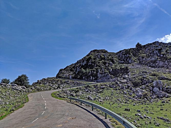
Photo: View from Mirador (lookout) 1 km from the finish.
Before heading to Spain for your cycling adventure, be sure to rely on our list of Things to Bring on a Cycling Trip, and use our interactive checklist to ensure you don't forget anything.
Hugh Carthy (UK; EF Pro Cycling) won his first stage in a Grand Tour in his seven year career with a final charge over the last 1200 meters of Angliru in Stage 12 of the 2020 Vuelta a España.
For the eighth time since 1999 (and first since 2017), Angliru will be a stage finish in the Vuelta a España in 2020.
![]()
Image: La Vuelta
2020 Vuelta a España Stage 12 November 1, 2020.
109.4 km mountain stage.
This may be the most popular Big Climb in Spain, even more so than Pico Veleta. The climb is very scenic and VERY HARD! On the face of it, 9.2% seems tough, but manageable. However, what separates Angliru from most Spanish bike climbs is its extremely steep segments that go well beyond 9%. There is an entire half-kilometer that averages nearly 20% (beginning about three kilometers from the top) and there are several briefer segments at 15%+.

This challenging bike climb has been made famous by the Vuelta a España.
Photos by PJAMM contributors Max Kueng of Zurich, Switzerland, Ard Oostra of Montreux, Switzerland, Charlie Thackeray of Ongar, United Kingdom, Ron Hawks of Las Vegas, Nevada, USA and Stephen Rockford, Ireland.

Distance and altitude signs each kilometer
Notice the grades: 10.4, 10.8, 11.1 . . . 16.2/23.5 😟😟

Roadway at kilometer 6.7 just before it pitches up dramatically.

Many grazing ranch animals on the climb.

Keep moving . . .

Views along the climb.


Climb’s Finish.

Summit monument.
VUELTA A ESPAÑA HISTORY
![]()
In their search for an attraction to match the other Grand Tours (such as TdF’s Alpe d’Huez/Mont Ventoux, and the Giro’s Mortirolo), the Vuelta organizers settled on Alto de l’Angliru.
![]()
Abraham Olano (ESP) led the 1999 Vuelta for stages 5-11 but yielded to Jan Ullrich on stage 12.
Olano leads the Vuelta on Angliru stage 8 September 12, 1999.
Photo: Rouleur
![]()
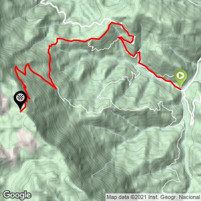
Route Map.
Photo: Marca
José Maria Jiménez won the Vuelta’s inaugural run up Angliru in 1999 and dedicated his effort to Marco Pantini who had been disqualified from that year’s event: “I dedicate it to Pantani by everything that he has suffered in this time.”
This very challenging climb has been included in the Vuelta a España (Spain’s Grand Tour) seven times from 1999-2017 (1999, 2000, 2002, 2008, 2011, 2013, and 2017). The climb was included in the Vuelta in 1999 as Spain’s answer to Alpe d’huez and Mount Ventoux of the Tour de France, and Mortirolo and Gavia of the Giro d’Italia.
The fastest ascent of Angliru was by Roberto Heras (ESP) in 2000.
In our opinion, the best quote for Angliru is, "What do they want? Blood? They ask us to stay clean and avoid doping and then they make the riders tackle this kind of barbarity," (Procycling, UK, November 2002).
Winners of Angliru stage
Chart: Wikipedia
Year Rider
1999 José María Jiménez (ESP)
2000 Gilberto Simoni (ITA)
2002 Roberto Heras (ESP)
2008 Alberto Contador (ESP)
2011 Wout Poels (NED)^
2013 Kenny Elissonde (FRA)
2017 Alberto Contador (ESP)
Ron Hawks’ Summary of Alto de l”Angliru:
Thank you Ron!
The Alto de Angliru is a grueling climb in the principality of Asturias in Northern Spain. Before we tackled this climb, we started from the city in Pola de Lena and climbed the Alto del Cordal. This climb is a nice little warm-up of 5.5 kms with an average grade of 9%. Once we descend into La Vega, we turn left at a sign for the Angliru which is shortly followed by a larger sign that shows the scary statistics of the Angliru. This is the official starting point, where the road starts going straight up immediately.

OK -- come and get it -- #22 World Climb!
As we pedal up the first part of the climb, the grade is between 7% to 9% which is very mild and was ridden very carefully as to save some energy for what we knew we were about to encounter. The scenery up this road, as it snakes its way up the mountain, is very beautiful, but we still don't see the peak of the Angliru -- which is probably a good thing. Around the 5km marker, the grade eases to around 2% as we ride through a plateau in the mountain with beautiful views of the rolling green mountains on both sides. This section is the last break we get until the last half-km, so we strongly suggest you use this break in the climb to get prepared for the hardest six kms of climbing we have ever encountered.
Before we get into the details of this section of the climb, it's important to note that the Angliru is considered the hardest climb of all the three grand tours. And after riding it, we concur completely that this climb is nothing to take lightly. When it comes to the Angliru, it's these six kms (from 6 km to 12 km) that make this climb the beast it truly is.
Now for the stats: The next six kms (from 6 km to 12 km) average over 14% with a maximum grade of 23.5%. The hardest stretch is a the 10 km marker where the grade for almost one whole km is at 20%. When we saw this stretch of the road carved into the side of the mountain, it didn't look real. It wasn't until we saw a car that passed us a while back making its way up this stretch of road did we realize what was in front of us.

As we start doing this climb, we took full advantage of the switchbacks to take them as wide as possible. In the corners of some of the switchbacks, the grade easily exceeds 30% so taking them wide is a matter of necessity. Surprisingly enough, the second steepest section of the climb is in the first kilometer (from 6 km to 7 km) with a maximum grade that exceeds 21%. Once we get through this stretch the next three kms (from 7 km to 10 km) stay pretty consistently around 12% to 16%, which looking back was probably the easiest part of this section of climbing. At a steep switchback we get to the 10 km marker and start climbing the road we saw on the lower slopes that didn't look real. After passing the 10 km marker, the grade goes to 20% and stays there all the way up this stretch of road and doesn't ease up until we get close the next switchback.
Exhaustion is kicking in and the pain from mashing on our pedals at 40 rpms at a glacial speed of 7 KPH (a tad over four MPH) has us swerving on the road and hoping we don't fall over, as there is no way we'd be able to get back on our bikes on this steep section of road. Once we get to the 11 km marker, the road gives us a little respite with a 13% grade, maximum of 20%, which feels like a flat after what we just climbed. This is the home stretch as once we get past the 12 km marker, the grade eases and the road actually turns flat, and we are able to jump into the big ring as we cross the finish line.
This is truly a remarkable climb that we will not soon forget. It gave us everything we could handle and then some but we found a way to will ourselves up this famous mountain that most tour pros consider to be inhumane. And after we experienced this climb firsthand, we would completely agree with that assessment.

Steepest Gradients by Distance:
![Grades.JPG]()
Steepest kilometer starts at km 10 (19%).