![IMG_6323.JPG]()
Cycling Etna Summit from the West is a US 100 Bike Climb
Ride 22.5 miles gaining 5,613’ to elevation 10,500 at 4.1% average grade.
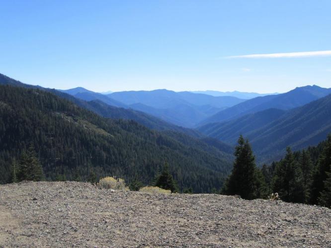
Etna Summit West is an extremely remote climb in a rugged area of Northern California over which the Pacific Coast Trail passes. The views at the summit are spectacular [see photo] and these are certainly climbs that should be considered when travelling through or staying in Northern California along the I-5 corridor. Although in a remote area, this is one of the 4 Top 100 Climbs in Northern California/Southern Oregon that are in close enough proximity to climb on a 2-3 day trip to the area.[1]
![]()
Approaching Etna Summit from the west.
![IMG_6323.JPG]()
View from the summit
![]()
PJAMM at Etna Summit - yeah!
ETNA SUMMIT WEST
The second half of this climb is a beast! We hit and stay at double digit grades from miles 3.9 to 6.4 (average grade over this stretch is a whopping 11.1%). Etna West is very remote, with little traffic, so bring appropriate provisions and tools - it can be a bit unnerving riding away from civilization down through the wide canyon that takes us to the bottom of the mountain and beginning of this climb. However, for those adventurers among us - it’s a blast!
![IMG_6290.JPG]()
![]()
“Hogan Mine” . . . the only sign of life we saw on this climb.
The roadway is in decent condition and one lane with no shoulder for the first 3.7 miles, then inexplicably turns to a fairly wide 2 lane road with double yellow center stripe at mile 3.7 which continues up and over the summit and for a few miles down the east side before turning back to a single lane (a real head-scratcher, that).
![IMG_6285.JPG]()
![IMG_6293.JPG]()
For most of the lower portion of the climb, we are surrounded by forest, so no distant views. However, towards the top of the climb, as we approach the Pacific Coast Trail, the view opens and we can see distant ridges to the west and east that are breathtaking.
![]()
Steepest ¼ mile begins at mile 3.9 (15.4%) and steepest mile at 5.5 (12.1%)
ETNA SUMMIT EAST
The east side of Etna Summit is not as steep as the west, yet it is still a very pleasant ride and well worth an up-and-over. The roadway (until near the top when it widens) is generally one wide lane, follows Etna Creek (although it is rarely actually in view) and is surrounded by forest until we near the summit. The narrow, tree-bordered roadway in this very remote area with minimal traffic gives us a very private feel and makes for a very comfortable and peaceful ride.
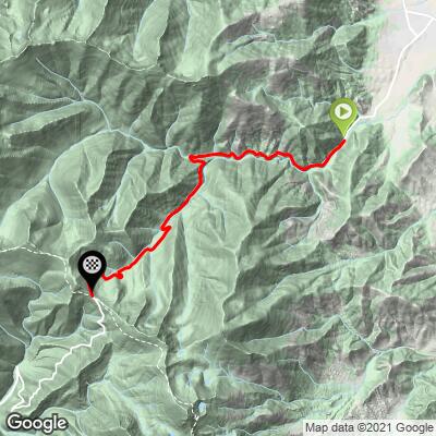
East/West Etna can be done as a great out-and-back route from the tiny Northern California town of Etna. Here is a Map of the out-and-back route. Overall, Etna Summit is a beautiful and challenging climb that should be included in your Northern California climbing itinerary.
![IMG_2509.JPG]()
About 1.5 miles from the summit.
![IMG_2509.JPG]()
Summit - looking from the east side to the western descent.
![]()
Steepest ¼ mile and mile begin at mile 3.2 (13.5% and 11.1% respectively)
[1] #59 Mt. Shasta 68 miles southeast, #86, Parks Creek East 73 miles east (via a roundabout route - not many direct routes in those parts) and #95 Mt. Ashland 80 miles north, just across the southern Oregon border.