![IMG_3875.JPG]()
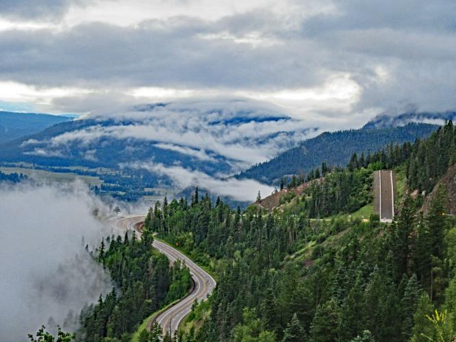
Cycling Wolf Creek Pass one of 3 Colorado Top 100 Bike Climbs crossing the Continental Divide.
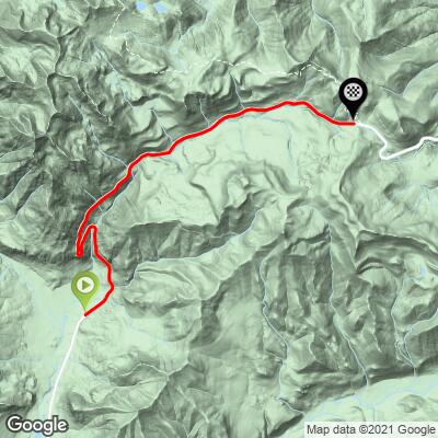
Ride 8.7 miles gaining 3,060’ to elevation 10,862 at 6.4% average grade.
Climb summary by PJAMM’s John Johnson.
This one is truly an outlier. Tucked away in deep southern Colorado, near its border with New Mexico, this fabulous bike climb begins just north of Pagosa Springs (elevation 7,126’; pop. 1,940 in 2017). We made the long trek down to southern Colorado just to document this climb. The climb is wonderful, but not such that it justifies a trip just to do the climb, unless you are completing the US Top 100 Bike Climbs, of course - Wolf Creek is ranked #84 on the US Hardest Climbs list.
![]()
Wolf Creek Pass is one of the most isolated Top 100 climbs and the furthest south in Colorado by a good stretch. The climb ends at Wolf Creek Pass, elevation 10,857 ending 1 mile short of Wolf Creek Ski Resort. This pass averages more snowfall than any other resort in Colorado and is one of the three Top 100 U.S. Climbs to pass over the Continental Divide.
![]()
Climb begins by riding north on Hwy 160 15 miles north of Pagosa Springs.
![]()
Nice views back to the south as we climb - 2 giant hairpins beginning at mile 1.9.
![]()
Colorado-style mobile home.
![IMG_3750.JPG]()
The # indicator of a long and steep descent (uhhhh . . . climb) . .
![]() .
.
Stacy Topping checks off yet another US Top 100 👍👍
Continental Divide Top 100 US Bike Climbs

Wolf Creek Pass (top photo) - southwest CO (Pagosa Springs)
Independence Pass - central CO (Aspen)
Cottonwood Pass - central CO (Buena Vista)

Trail Ridge - stops 9 miles short of the Divide.
Thanks to contributor Jerry Nichols who provided us an excellent and comprehensive summary of the climb:
Wolf Creek Pass from the south is truly an epic climb. I have ridden over twenty of Colorado’s paved mountain passes and Wolf Creek Pass is one of my favorites. This is a fun ride partly because I enjoy a challenging climb but mainly because of the incredible views. The ride starts out with a rolling climb of about 2-3% through heavily forested hills. The scenery includes lakes, horse pastures, and a view of the East Fork San Juan River.
As you head north to the base of the climb you are faced with an intimidating view of a towering granite rock wall which appears to be blocking your way. This is where the grade changes from 3% to 7+%. Double switchbacks lie ahead as you begin the climb up the side of this wall where the grade exceeds 8%. As you work your way through the switchbacks you are rewarded with spectacular views of the valley floor to the south. This is my favorite part of the ride.
Once you have made it through the switchbacks the road straightens out and the grades level out to around 5-7% which is all the respite you will get with just over 5 miles of climbing left to reach the summit. This section of the climb has rocky bluffs from the road cut climbing up to treed hillsides on your left and trees sloping down to Wolf Creek on your right. As you continue on your climb there are a couple of small waterfalls coming down the rocks to your left which are running most of the year.
There are a number of scenic pullouts along the climb and unless you are in a hurry it is worth the time to stop and take in the sights. As you approach the summit you will see a low point in the mountains ahead which is where the pass cuts across the top of the continental divide. There is a large pull out there but no facilities. You will likely see other cyclists at the top congratulating each other on completing a great climb.
The road condition on this climb is excellent and there is a good shoulder for cyclists however, weather conditions at the top of this climb can be unpredictable at 10,857 feet. Depending on the time of the year you need to be prepared for cold temperatures at the summit with a possibility of snow.
C.W. MCALL’S WOLF CREEK PASS
"C.W. McCall" is the pseudonym of William Dale Fries Jr., an American singer, activist, and politician. C.W. McCall is best known for his truck-themed outlaw country songs and his spoken-word style of singing, which was quite popular in the 1970s.
"Wolf Creek Pass" is one of his most iconic songs, released in 1975 as part of the album "Black Bear Road." The song tells a humorous story about a trucker who loses control of his 18-wheeler while descending Wolf Creek Pass in Colorado, eventually crashing into a feed store in Pagosa Springs.
Here's a brief outline of the song:
- The Setup: The song begins with the singer and his partner, Earl, starting their trip from the top of Wolf Creek Pass in a loaded-down semi-truck, which they're driving to Pagosa Springs.
- The Descent Begins: As they begin their descent, they quickly realize the brakes aren't working effectively.
- Out of Control: Despite their efforts to use low gears and the emergency brake, the truck starts going faster and faster.
- Humorous Observations: As they descend, McCall humorously narrates the various signs and situations they pass by, including passing trucks, running through a tunnel, and scaring some birds.
- The Crash: In the climax, the runaway truck crashes into a feed store in Pagosa Springs, sending feed everywhere and causing chaos.
- The Aftermath: The song concludes with a humorous observation about the incident: "You could feed the city of Denver for a full year on the lettuce we smashed in that one little trip."
- "Wolf Creek Pass" epitomizes McCall's style, blending humor, spoken-word narrative, and an authentic representation of trucker culture. The song was a hit and remains one of the defining tracks of C.W. McCall's career.