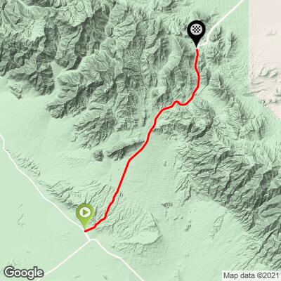
23.6
PDI
12.8 mi
DISTANCE
4,133 ft
GAINED
6.1 %
AVG. GRADE
FULL CLIMB STATS
Page Contributor(s): Bruce Hamilton, La Quinta, CA; Stacy Topping, Tacoma, WA; Carla and Tom Morton, Granger, IN.
INTRO
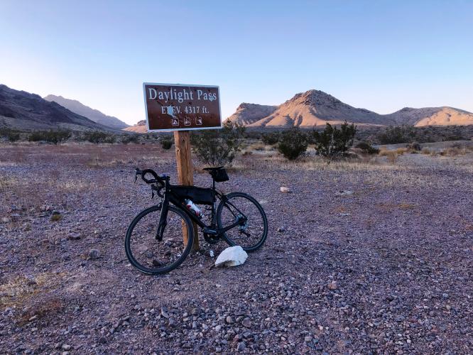
The climb begins in the heart of Death Valley NP and ends just west of the California/Nevada state line. The first several miles of this climb are on a long, straight road that can be demoralizing in the heat.
"To begin, head east on shallow grade along Route 190 from San Dunes Road for one mile then turn left on Scottys Castle Road. After a half mile turn right toward Beatty, Nevada on Daylight Pass Road over slightly increased grade. This stretch is quite straight with good views of the surrounding mountains (and a fast finish on the descent). After passing the junction with the Beatty Cut-off Road (right) the grade increases over the final miles to finish at Daylight Pass (4,317 feet)..." (This quote is presented with the approval of John Summerson, from his book, The Complete Guide to Climbing (by Bike) in California, pg. 136.)
PLAN YOUR ROUTE
See more details and tools regarding this climb's grade via our interactive Profile Tool.
Information Not Available
If you have any information regarding this climb, we'd like to hear from you. Click the CONTRIBUTE button to share your thoughts with us.
Information Not Available
If you have any information regarding this climb, we'd like to hear from you. Click the CONTRIBUTE button to share your thoughts with us.
Before heading out on any cycling adventure check out our Things to Bring on a Cycling Trip and use our interactive check list to ensure you don't forget anything.
Information Not Available
If you have any information regarding this climb, we'd like to hear from you. Click the CONTRIBUTE button to share your thoughts with us.
ROUTE MAP
MEMBER RATING
CURRENT WEATHER
PJAMM TRIPS ADVENTURE STARTER BUNDLES
Check out PJAMM Adventure's prepackaged (self-guided) cycling trips. They will help you plan, document and conquer your next adventure.
NEARBY CLIMBS (0) RADIAL PROXIMITY
FROM No Climbs Found
MEMBER REVIEWS & COMMENTS
Let us know what you thought of this climb. Signup for our FREE membership to write a review or post a comment.
Already have an account?
LOG IN HERE
Jghanaie
This is a good short climb! Would be good to do from Furnace Creek. Might try and extend further to the ghost town as an adventure trip.
carlinguernsey
Another good test out of Death Valley. The times I've done it, there have been gusty side winds on the descent that can literally blow you off the road. You can easily start from Stovepipe Wells. Bring plenty of water if you plan to start from Furnace Creek (and consider the Beatty Road option).
jsummers
Another of the big climbs out of Death Valley, Daylight Pass carries a mostly steady grade up to its summit through desolate scenery. A bit warm unless you go in the winter, its a fun and fast descent as well. It can be combined with multiple climbs for a big day.