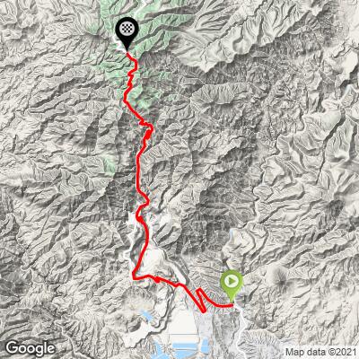
Morenci Mine Bike Climb - PJAMM Cycling

4.9
FIETS
23.1 mi
DISTANCE
4,634 ft
GAINED
3.2 %
AVG. GRADE

FULL CLIMB STATS

Page Contributor(s): Rochelle Cook, CA

INTRO

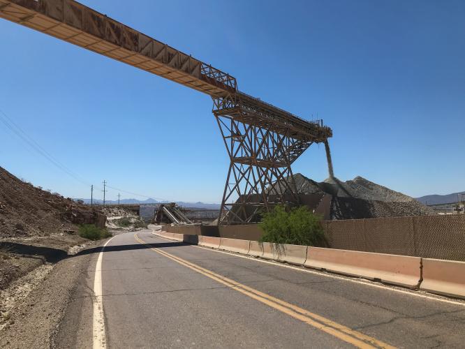
Climb directly through an active copper mine for the first half, then ride high into the red rocks and pines of the Apache National Forest during the second. 

Watch enormous mining trucks haul tons of rocks around the mine, as well as gravel "waterfalls" - free in-ride entertainment!

See more details and tools regarding this climb's grade via our interactive Profile Tool.
Parking:
You can park at Riverside Park on Frisco Ave. at the start of the climb

Roadway:
There is a well paved (but often gravelly) wide shoulder until you pass the town of Morenci and head into the mine, but at that point, there's virtually no traffic. It's a safe ride- no large mining trucks are permitted to drive on this road, or even cross it. 
Gas stations and small restaurants in the towns of Clifton and Morenci, once entering the mine, the climb is unsupported.
Before heading out on any cycling adventure check out our Things to Bring on a Cycling Trip and use our interactive check list to ensure you don't forget anything.
Tucson is the cycling hub of Southern Arizona, with Mt. LemmonKitt Peak, and Mt. Graham within close proximity.  Here's a list of Hotels or Rental options in Tucson.

Food & Local Brews (☕️+🍻): There isn't much around Clifton or Morenci, but Tucson's Mexican food is unparalleled anywhere else in the US. Presta Coffee Roasters is the best cafe in the region.  A short drive south is our favorite Arizona brewery, Tombstone Brewing Co., next to the historic site of the 1881 gunfight at the O.K. Corral.


ROUTE MAP

MEMBER RATING

Difficulty: Challenging
3
Road
5
Traffic
5
Scenery

CURRENT WEATHER

PJAMM TRIPS ADVENTURE STARTER BUNDLES

Check out PJAMM Adventure's prepackaged (self-guided) cycling trips. They will help you plan, document and conquer your next adventure.
ALL TRIPS
Browse all of our prepackaged trips and find your next adventure!
Arizona: Cycling and Spring Training
United States (AZ)
17 ROUTES
48 POIs
ROUTE STATS (TOTAL)
360.3
mi
DISTANCE
33,516
ft
ELEV. GAIN
Arizona: Mt. Lemmon
United States (AZ)
11 ROUTES
28 POIs
ROUTE STATS (TOTAL)
62.4
mi
DISTANCE
16,765
ft
ELEV. GAIN
The American Southwest
United States (AZ,NM,UT)
18 ROUTES
27 POIs
ROUTE STATS (TOTAL)
215.4
mi
DISTANCE
34,866
ft
ELEV. GAIN

NEARBY CLIMBS (0) RADIAL PROXIMITY

FROM
No Climbs Found

MEMBER REVIEWS & COMMENTS

Let us know what you thought of this climb. Signup for our FREE membership to write a review or post a comment.
Already have an account?

Mar 20, 2021
difficulty: Challenging
scenery: 5
traffic: 5
road: 3
Mar 20, 2021
scenery: 5
traffic: 5
road: 3
Also known as the Coronado Trail, or Devil's Highway (previously Route 666). Going through the mine is a surreal experience. Once you clear that, it's a beatiful and quiet climb. Strava activity with a few pics: https://www.strava.com/activities/4505938732
ROUTE MAP
PROFILE TOOL
Route Data
S.G. (%)
hide
Segment Data
hide

Climb Profile Not Found
CLIMB SUMMARY

This is certainly the most entertaining climb in Arizona - the first 15 miles takes you through an active copper mine, with digging going on 7 days a week, and enormous dump trucks hauling rocks all around the quarry.

We really had a heck of a time getting the profile and route map for this one. The road (AZ 191/Coronado Trail) has so recently been re-routed through the mine by the mining company, that Google Maps still shows the previous version of the road (although the imagery is updated on google earth). So even when we tried to manually have the route follow the new road, the topographical data went wild, showing that there were 90% and -30% grades in some places! All this led to enough frustration that I (Sam Lyons @sam.lionman) decided to drive down from Phoenix and get the route data myself - by riding it!  Although, that meant I had no idea how long or steep the climb would be, and ran out of water in 90+ degree Arizona sun…

Bike Climb gradient profile for a cyclist and climbing cyclists, of Morenci Mine Arizona. From PJAMM cycling

The climb starts in Clifton, a small town in a canyon just underneath the mine. There’s a parking lot at a public community park right at the start of the climb.

There’s tons of wildlife in this area!

All within the first 2 miles of the climb in the town of Morenci.

Once you get out of Morenci, this is an… unsupported climb… to say the least

Morenci is home to one of the largest copper sources in the world. Each year, 3,300 employees bring up between 700 and 900 million pounds of copper.

Part of the in-ride entertainment includes huge gravel “waterfalls”. Noisy and dusty, but fascinating!

The exact same type of trucks I used to play with as a kid!

There’s a nice shoulder and very low traffic - no big mining trucks are permitted on the road.

This really is two climbs in one - once you pass the mine, it’s like you’re in a different universe, with how much the colors and foliage change.

The roadway isn’t bad, but around the same quality as Mt. Graham in some places, in others, freshly paved (overall, probably around 50-50). It was bumpy and gravelly enough however that I personally didn’t feel like taking the descent fast.

Dark red cliffs reminiscent of Sedona

The view from the top, HI Saddle Picnic Point, with the mighty Mount Graham in the far off distance.