
16.2
PDI
8.6 mi
DISTANCE
2,760 ft
GAINED
6 %
AVG. GRADE
FULL CLIMB STATS
INTRO
Ayguatébia gets its name from the Latin aqua tepida, lukewarm water, and for a rider its fountain is the one that matters: it's the last water before the col. This is the shorter, more direct way to the Col de la Llose. Instead of swinging round by Railleu like our Olette to Col de la Llose route, the D4c heads straight up through Talau and Ayguatébia, two tiny villages that together had 49 residents in 2023. From the junction near Oreilla it's 13.8 km (8.6 mi) at 6%, with 841 m (2760 ft) of climbing to the col at 1863 m (6112 ft).
It's irregular more than hard. The road keeps switching between pitches of 7.8 to 8.2% and short easier stretches of 3 to 4%, so you're forever shifting, but no full kilometer is steeper than about 8.2%. Talau sits on the slope above the Cabrils valley, and from Ayguatébia there are views back across the Conflent to the Canigou. Higher up the road climbs through beech woods, then open, sweet-smelling pine forest, and over the last 3 km it joins the road coming up from Railleu.
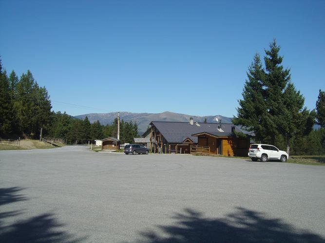
The col is a wide clearing at the Col de la Llose Nordic ski area, with a big car park and a timber lodge. In winter it's busy with cross-country skiers; in summer it's mostly empty, and the best views are the ones behind you on the way up rather than at the top. Riders who want more push on toward the Puig de la Tossa (2032 m) from just past the col, but it's army ground: the road crosses a firing range, a board lists the days it's closed, the tarmac gives out before the top and the summit itself is off limits.
PLAN YOUR ROUTE
 We've partnered with Sherpa-Map.com to bring you the best route planning tool. With a PRO Membership you can use this climb as a reference when creating your route.
The D4c averages 6% over 13.8 km (8.6 mi), but the profile is a sawtooth. Half-kilometer pitches of 7.8 to 8.2% (km 2 to 3, 4.5 to 5, 5.5 to 6.5, 7 to 7.5 and 10.5 to 11) alternate with easier stretches of 3 to 4% (km 1 to 1.5, 5 to 5.5, 6.5 to 7, 8.5 to 9 and 10 to 10.5). There's also a short, steep kick in the first kilometer.
The steepest kilometer averages 8.2%, the steepest 2 km 7.1%, the steepest 5 km 6.8% and the steepest 10 km 6.2%. The climbing gets steadier near the top: the last 2.8 km hold about 4 to 6.5% through the pines to the col.
Roadway: Sealed all the way on a narrow mountain road. Riders rate the surface good, with loose gravel in places, mostly on the upper stretches, so take the bends carefully coming down. The col sits at 1863 m and becomes a cross-country ski area in winter, so expect snow from late autumn to spring and check the Pyrénées-Orientales department's road information before going up out of season.
Traffic: Almost none. The D4c serves Talau, Ayguatébia and the ski area, and riders have counted fewer than ten cars on a full summer round trip.
Parking: There's nowhere set up for parking at the junction near Oreilla, so most riders start in Olette, in the Têt valley, and ride the D4 up to the start - our Olette to Col de la Llose page covers the village. At the top, the Nordic area's large car park is handy for a pickup (Street View just below the col).
Gear: Nothing here goes much past 8%, so ordinary compact gearing is enough. The bigger concern is exposure: shade is patchy and the col sits at 1863 m, so a jacket for the way down earns its place in the pocket, July included.
Provisions: Fill up at the fountain in Ayguatébia, about 4.5 km in - after that there's no water we know of before the col. Olette is the last place to buy food. At the top, the Chalet du Col de la Llose has a restaurant and rents mountain bikes in summer as well as skis in winter, but its hours vary, so treat it as a bonus rather than the plan.
Before heading out on any cycling adventure check out our Things to Bring on a Cycling Trip and use our interactive check list to ensure you don't forget anything.
Olette is the place to base yourself for this corner of the Conflent. It's a stop on the Train Jaune, the narrow-gauge line up to the Cerdagne, and our Olette to Col de la Llose and Col de Creu climbs both start there. This road and the Railleu road meet just below the col, so you can make a loop: up through Ayguatébia, down past Sansa and Railleu, or the other way round.
In Ayguatébia, look in at the church of Saint-Félix, a listed monument; the village may also have been the birthplace of Saint Ermengol, bishop of Urgell in the early 11th century. Over the col the road drops to La Llagonne and Mont-Louis, whose star-shaped Vauban fortress is a UNESCO World Heritage site and a good coffee stop. Open Routes in the Area on this page to see how the Llose, Creu and Mont-Louis roads fit together.
ROUTE MAP

MEMBER RATING
CURRENT WEATHER
PJAMM TRIPS ADVENTURE STARTER BUNDLES
Check out PJAMM Adventure's prepackaged (self-guided) cycling trips. They will help you plan, document and conquer your next adventure.
NEARBY CLIMBS (0) RADIAL PROXIMITY
FROM No Climbs Found
MEMBER REVIEWS & COMMENTS
Let us know what you thought of this climb. Signup for our FREE membership to write a review or post a comment.
Already have an account?
LOG IN HERE
