Mt. Disappointment Bike Climb - PJAMM Cycling

3.7
FIETS
3.1 mi
DISTANCE
1,255 ft
GAINED
7.6 %
AVG. GRADE

FULL CLIMB STATS

INTRO

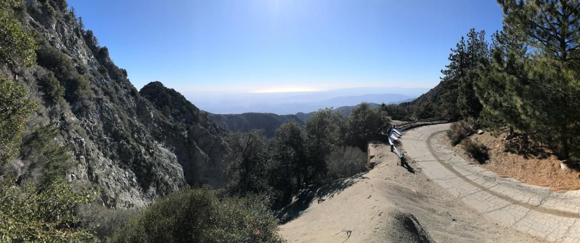
Decide for yourself, but after the famous GMR, we think this might be the most scenic climb in the San Gabriel Mountains.  This old road (closed to cars) winds through groves of pines with some of the best views of the Angeles Crest Hwy and the canyons it winds through, as well as 360 degree views of the entire city of Los Angeles all the way to the ocean.

See more details and tools regarding this climb's grade via our interactive Profile Tool.
Roadway & Traffic:
The road is old and not maintained, but rideable on 25 roads. Bring a spare tube and be careful descending, since you will likely only run into hikers. 
Road is closed to traffic year round, open to hikers and bicyclists.

Parking:
You can park at the Bill Reily Trailhead right at the start or the Red Box Picnic Area a few hundred yards away, but both require a recreation pass for the National Forest.  We recommend parking down in La Cañada Flintridge and combining this climb with the full Mt. Wilson route.
This climb is unsupported. There's water and restrooms at the Red Box Picnic Area near the start, and food, water, and restrooms at the Cosmic Cafe on the top of Mt. Wilson. 
Before heading out on any cycling adventure check out our Things to Bring on a Cycling Trip and use our interactive check list to ensure you don't forget anything.
If you're going to do this climb we highly recommend pairing it with others in the San Gabriel Mountains, such as Mt. BaldyGlendora Mountain RoadMt. GleasonHwy 39 - Dawson Saddle, and of course, Mt. Wilson.  Check out our full Ride Suggestions in the Full Summary to find routes to plan your next ride.
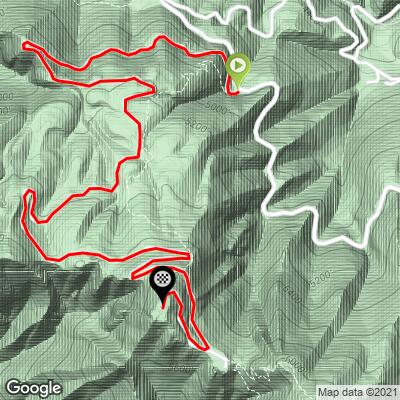
If traveling to do these climbs, the best places to stay are either in Pasadena or in Azusa, closer to Mt Baldy and the GMR.

ROUTE MAP

MEMBER RATING

Not Yet Rated
-
Road
-
Traffic
-
Scenery

CURRENT WEATHER

PJAMM TRIPS ADVENTURE STARTER BUNDLES

Check out PJAMM Adventure's prepackaged (self-guided) cycling trips. They will help you plan, document and conquer your next adventure.
ALL TRIPS
Browse all of our prepackaged trips and find your next adventure!
San Gabriel Mountains
United States (CA)
38 ROUTES
43 POIs
ROUTE STATS (TOTAL)
677.5
mi
DISTANCE
80,483
ft
ELEV. GAIN

NEARBY CLIMBS (0) RADIAL PROXIMITY

FROM
No Climbs Found

MEMBER REVIEWS & COMMENTS

Let us know what you thought of this climb. Signup for our FREE membership to write a review or post a comment.
Already have an account?
ROUTE MAP
PROFILE TOOL
Route Data
S.G. (%)
hide
Segment Data
hide

Climb Profile Not Found
CLIMB SUMMARY

Mt Disappointment is anything but. This climb is absolutely breathtaking, and must-do if you’re into getting off the beaten path and away from cars.

As we were, you’re probably wondering about the name of the mountain. The peak is called “Mt. Disappointment” because in 1894, surveyors climbed to the top of the peak thinking it was the highest in the western San Gabriels, so they could measure the surrounding peaks in the area.

Disappointingly, they found out that San Gabriel Peak (pictured) directly next was slightly higher.

The climb starts off the west side of the Mt.Wilson-Red Box Road, which takes you 4 more miles to the summit of Mt. Wilson, another great and scenic climb. There’s a gravel spot to park for the trailhead right at the start:

Some of the best views of the ocean you’ll find in the San Gabriels

There’s a brief flat section right before beginning the final push to the summit. Use this part to rest for the next section!!!  The profile is not wrong - there really is a full ¼ of a mile that averages 17%.  We’ve done this climb 3 times and it hasn’t beaten us yet, but it’s come close…

After a quarter mile of agonizing pain (or walking, no shame in that here!), you reach an amazing 360 degree view at the top, but it’s less fun due to an annoying high-pitched ringing sound coming from the radio receivers. Bring earplugs if you want to hang out here and soak in the views for a while.

Access to full Climb Summary requires a PJAMM Cycling PRO Membership!

It takes less than a minute to sign up & with your PRO membership you can:
  • Rate climbs, post comments and share your experiences on any of our climb pages
  • Create bucket lists of climbs & mark the dates you complete them
  • Weather data for all climbs - Start & Finish
  • Upload photos to your member page to customize your PJAMM Cycling experience
  • Utilize all of our interactive tools - Profile & Routes in Area
  • Download climb route .gpx files
LEARN MORE
SIGN UP

Already have an account? LOG IN HERE