17.3
PDI
10.5 mi
DISTANCE
3,189 ft
GAINED
5.7 %
AVG. GRADE
FULL CLIMB STATS
INTRO
Cycling Mt. Diablo from the South: This is one of the more scenic bike climbs in the East Bay. With its 360 degree views from the top, this is one of the great viewpoints of the Bay Area. Mt. Diablo is likely the most popular bike climb in the Bay Area. It is also one of the five "must do" mountains to climb by bike in the Bay Area, along with Mt. Tamalpais (Marin County), Mt. St. Helena (Napa County), Mt. Hamilton (Santa Clara County), and Mt. Umunhum (Santa Clara County).
PLAN YOUR ROUTE
This climb averages nearly 6% but is fairly steady throughout. 35% (3.7 miles) are at 0-5% grade, 52% (5.5 miles) 5-10% and 8% (.8 mile) is at 10-15%. The steepest quarter mile is 11.9% and steepest mile 8.4% beginning about two miles from the top. The toughest section of the climb is the last 100 yards at 16% just before the summit.
See more details and tools regarding this climb's grade via the “Profile Tool” button above.
Roadway: The roadway is pristine from start to finish.
Traffic: Traffic moves slowly through the 25 mph park section and this is a very safe climb. There are many "share the road" signs along the climb as a testament to the State Parks support for cyclists.
Traffic: Traffic moves slowly through the 25 mph park section and this is a very safe climb. There are many "share the road" signs along the climb as a testament to the State Parks support for cyclists.
Fee: As of 2021 - none. See, parks.ca.gov
Parking: There is some, but not a lot of, street parking along the first mile of the climb. We have always parked at The Athenian School on Mt. Diablo Scenic Boulevard (Map).
Provisions: There is a water fountain behind the Junction Ranger Station (mile 8) and a snack machine and water at the top.
Before heading out on any cycling adventure check out our Things to Bring on a Cycling Trip and use our interactive check list to ensure you don't forget anything.
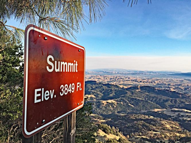
Visit the Mt. Diablo Summit Museum at the finish of the climb and the observation deck with excellent views of the East Bay and San Francisco Bay. Staying in nearby Walnut Creek has several options.
There is also camping and hiking in the Mt. Diablo State Park (20,000 acres). See also, All Trails Best Hikes in Mt. Diablo State Park.
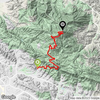
Consider riding both South and North Mt. Diablo climbs. This is a 34 miles 5,065' out and back route (Map). Use the Routes in Area tool to see other bike climbs in this area.
ROUTE MAP
MEMBER RATING
CURRENT WEATHER
PJAMM TRIPS ADVENTURE STARTER BUNDLES
Check out PJAMM Adventure's prepackaged (self-guided) cycling trips. They will help you plan, document and conquer your next adventure.
NEARBY CLIMBS (0) RADIAL PROXIMITY
FROM No Climbs Found
MEMBER REVIEWS & COMMENTS
Let us know what you thought of this climb. Signup for our FREE membership to write a review or post a comment.
Already have an account?
LOG IN HERE
paulf992
Choose your time to avoid traffic and this is a lovely ride. I suggest weekday mornings. Great views and a steady grade with a few breaks and steep sections make this a true classic climb and sweet descent.