9.7
PDI
7.9 mi
DISTANCE
2,053 ft
GAINED
4.5 %
AVG. GRADE
FULL CLIMB STATS
INTRO
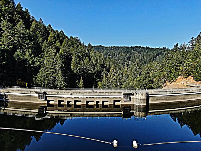
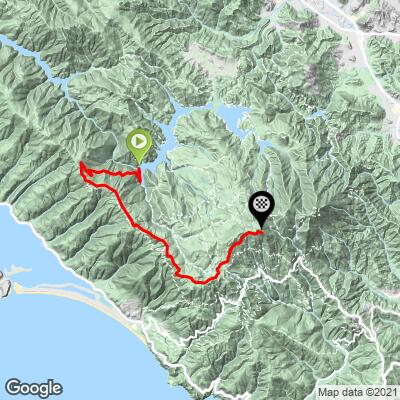
This climb is one of the five primary climb routes to the top of Mt. Tamalpais in Marin County, and may be the most scenic of them all. The climb begins at Alpine Dam in western Marin County and climbs up Fairfax-Bolinas Road for 2.5 miles before turning into Ridgeview Boulevard which we climb for 5.5 miles before finishing at the West Peak of Mt. Tamalpais.
PJAMM's Adventure App preloaded trips are viewed near the bottom of the page and include the Mt. Tam and Bay Area Most Scenic trips (Mt. Tam from Alpine Dam is PJAMM's selection for Bay Area #1 Most Scenic Bike Climb).
PLAN YOUR ROUTE
The 2.5 mile climb on Fairfax-Bolinas Road is a fairly steady and healthy ascent averaging 6.8%. The next four miles to on Ridgecrest Boulevard to its junction with Pantoll Road is south along a nice ridge line and over rollers averaging 2.3%. The final 1.2 miles to West Peak average 7.2%. The climb's steepest quarter-mile is 9.6% and begins about a quarter-mile into the climb, while the 8.1% steepest mile begins at mile 1.2. 11% of the climb is at 10%+.
Roadway: Excellent.
Traffic: Minimal and slow moving.
Provisions: There are no stores or facilities with water or food on this route.
Before heading out on any cycling adventure check out our Things to Bring on a Cycling Trip and use our interactive check list to ensure you don't forget anything.
We have documented the five primary routes to the West Peak of Mt. Tam - find those routes and other Marin County bike climbs here: Marin County. Also consider riding across the Golden Gate and up to the top of Mt. Tam and back - Golden Gate - Mt. Tam
Mt. Tam's East Peak we can see the Farallon Islands, Marin County hills, San Francisco Bay and City, Angel Island, the Bay Bridge, East Bay, Mt. Diablo and on a rare crystal clear day the snow capped Sierra Mountains 150 miles east. - Google Street View. There is also a Visitor Center and Gravity Barn at the East Peak. You can get information, history, water and snacks at the East Peak Visitor Center. Also visit the Gravity Barn Museum which is a tribute to the old railway that climbed Mt. Tam.
ROUTE MAP
MEMBER RATING
CURRENT WEATHER
PJAMM TRIPS ADVENTURE STARTER BUNDLES
Check out PJAMM Adventure's prepackaged (self-guided) cycling trips. They will help you plan, document and conquer your next adventure.
Mount Tamalpais
United States (CA)
8 ROUTES
0 POIs
ROUTE STATS (TOTAL)
100
mi
DISTANCE
21,416
ft
ELEV. GAIN
San Francisco Bay Area
United States (CA)
25 ROUTES
30 POIs
ROUTE STATS (TOTAL)
487.9
mi
DISTANCE
65,482
ft
ELEV. GAIN
NEARBY CLIMBS (0) RADIAL PROXIMITY
FROM No Climbs Found
MEMBER REVIEWS & COMMENTS
Let us know what you thought of this climb. Signup for our FREE membership to write a review or post a comment.
Already have an account?
LOG IN HERE
lirizar1
First segment (1.5 miles) in the woods has by far the worst pavement and pretty consistently steep but super relaxing and feeling good with nature. Manageable to get through all the potholes and cracks in the road to go up but a brutal arm/ braking workout to descend. Next section on 2.5% grade with rolling hills is super misleading. This is a series of kicker after kicker. Each uphill is 10%+ and then you get downhill. This repeats for about 5 miles. Albeit the beautiful views if you have the chance to enjoy. Then once you turn left the final stretch has beautiful views and is a consistent grade on the climb. Pavement is good for the last two segments with light traffic the entire time. I would argue this is both the most scenic and most difficult way up to the peak of Mt. Tam.