20.1
PDI
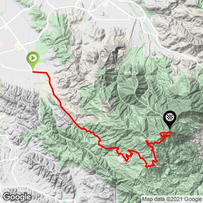
12.4 mi
DISTANCE
3,735 ft
GAINED
5.6 %
AVG. GRADE
FULL CLIMB STATS
INTRO
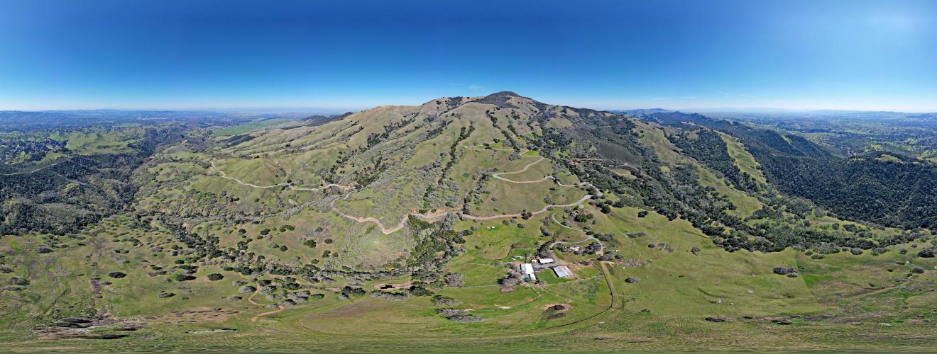
Mt. Diablo from Walnut Creek (north) is the fifth most difficult bike climb in the Bay area. The northern and southern approaches to the summit merge for the final 4.5 miles to the summit. At the summit there is an observation platform giving us the best 360 degree views in the East Bay. Mt. Diablo is also one of the five "must do" mountains to climb by bike in the Bay Area, along with Mt. Tamalpais (Marin County), Mt. St. Helena (Napa County), Mt. Hamilton (Santa Clara County), and Mt. Umunhum (Santa Clara County).
PLAN YOUR ROUTE
The first 2.7 miles of this climb are a great warm up at 2.2% average grade. 33.5% (4.1 miles) is at 0-5%, 55% (6.7 miles) 5-10% and 7.4% (.9 miles) is at 10-15%. The steepest quarter mile is 10.5% and steepest mile 8.4%.
See more details and tools regarding this climb's grade via the “Profile Tool” button above.
Roadway: The roadway is pristine from start to finish.
Traffic: Traffic moves slowly through the 25 mph park section and this is a very safe climb. There are many "share the road" signs along the climb as a testament to the State Parks support for cyclists.
Fee: As of 2020, there was no charge to enter the park on bike or foot, but double check that at California State Park Entry Fees & Passes site.
Parking: I have always parked along Oak Grove Road just before N. Gate Road -Map; Street View.
Provisions:
Tons! This is our vote for the most cyclist friendly climb in the United States. There is a water fountain behind the Junction Ranger Station (mile 8) and a snack machine and water at the top. There's also a full bike repair station - a locker filled with free tubes, spare tires, air pump, and multitools.
Before heading out on any cycling adventure check out our Things to Bring on a Cycling Trip and use our interactive check list to ensure you don't forget anything.
Booking your travels through one of these links helps us continue to bring you awesome info on climbing and cycling. Thank you!
Visit the Mt. Diablo Summit Museum at the finish of the climb and the observation deck with excellent views of the East Bay and San Francisco Bay and City (Google Map + Reviews). There is also camping and hiking in the Mt. Diablo State Park (20,000 acres). See also, All Trails Best Hikes in Mt. Diablo State Park.
Consider doing both Mt. Diablo North Gate and South Gate climbs together - this is a 37 miles 5,230'' out and back (Map).
ROUTE MAP
MEMBER RATING
CURRENT WEATHER
PJAMM TRIPS ADVENTURE STARTER BUNDLES
Check out PJAMM Adventure's prepackaged (self-guided) cycling trips. They will help you plan, document and conquer your next adventure.
NEARBY CLIMBS (0) RADIAL PROXIMITY
FROM No Climbs Found
MEMBER REVIEWS & COMMENTS
Let us know what you thought of this climb. Signup for our FREE membership to write a review or post a comment.
Already have an account?
LOG IN HERE
nickridesbikes
I rode this yesterday (9/22/2024) midday and had a great time. Temps were in the mid-70s, but the climb felt warm since it's fully exposed. Very few cars, which is a plus. Highly recommended if you're in or near the Bay Area.
Huber.J
Lovely climb overall. Rode it on a Friday morning in mid-October, and it was quite warm. Road condition is pretty good, but some dips and cracks on the way down will slow one's descent. Maybe 10 cars total passed me going up, and there are numerous signs for cars not to pass cyclists on blind turns. Small station at top with snacks & souvenirs.
bcerles
Very nice regular climb with some steep but short passage. Beware the last 500 meters to the light house at the end which are steep, > 12%!
rbristow


Steady climb, ramps up after the junction. Incredible 360 views on a clear day make it worth the effort to the top!
RyanH
One of my favorites, pretty much sweeping views the entire way up
Jeffteng2006
This is north gate route, but I rode South Gate route a lot which is 11mi long


