Welch Creek Road Bike Climb - PJAMM Cycling

14.9
PDI
3.8 mi
DISTANCE
1,915 ft
GAINED
9.5 %
AVG. GRADE

FULL CLIMB STATS

INTRO

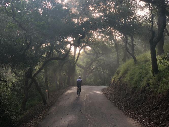
Welch Creek Road is ranked the ninth most difficult bike climb in the San Francisco Bay Area.  The climb is on a very narrow road which winds on a steep grade up through a dark canyon for its first half, before emerging into open space and rolling hills. 

Welch Creek Road is PJAMM's selection for eighth most scenic bike climb in the Bay Area. The PJAMM Adventure App's preloaded trip for the Bay Area's Top 10 Most Scenic climbs are viewed near the bottom of this page. 

PLAN YOUR ROUTE

We've partnered with Sherpa-Map.com to bring you the best route planning tool. With a PRO Membership you can use this climb as a reference when creating your route.
9.9% average grade (10.2% climb only).  27% of the climb is in the 10-15% range, 19% at 15-20% and 2.5% ≥20%.  The steepest quarter mile is 17.5%.

See more details and tools regarding this climb's grade via the “Profile Tool” button above.
Roadway:  Narrow, one lane in good shape.  There has been one report that a resident claimed the upper portion of the roadway is private, but we have seen no signs or have any evidence to prove that. 

Traffic:  Minimal.  Be careful on the descent because the road is steep, narrow, and dark in the canyon and may have some debris on it. 

Parking:  Park at climb start.  Map; Street View
Gear:  No special gear is needed on this climb. 

Provisions:  None on the climb. 
Before heading out on any cycling adventure check out our Things to Bring on a Cycling Trip and use our interactive check list to ensure you don't forget anything.
This climb is a bit of an outlier -  Mt. Diablo - South Gate is roughly 25 miles north and Mt. Hamilton West 20 miles south.

You can stay in nearby Pleasanton to take on this and other climbs in the area.  House rentals are also available in the area.   

Use the Routes in Area Tool on the menu bar above to see other bike climbs in this area. 

ROUTE MAP

MEMBER RATING

Difficulty: Strenuous
4
Road
5
Traffic
2
Scenery

CURRENT WEATHER

PJAMM TRIPS ADVENTURE STARTER BUNDLES

Check out PJAMM Adventure's prepackaged (self-guided) cycling trips. They will help you plan, document and conquer your next adventure.
ALL TRIPS
Browse all of our prepackaged trips and find your next adventure!
San Francisco Bay Area
United States (CA)
25 ROUTES
30 POIs
ROUTE STATS (TOTAL)
487.9
mi
DISTANCE
65,482
ft
ELEV. GAIN
San Francisco Bay Area: Most Scenic Bike Climbs
United States (CA)
10 ROUTES
0 POIs
ROUTE STATS (TOTAL)
86.9
mi
DISTANCE
25,759
ft
ELEV. GAIN

NEARBY CLIMBS (0) RADIAL PROXIMITY

FROM
No Climbs Found

MEMBER REVIEWS & COMMENTS

Let us know what you thought of this climb. Signup for our FREE membership to write a review or post a comment.
Already have an account?

May 16, 2024
difficulty: Strenuous
scenery: 2
traffic: 5
road: 4
May 16, 2024
scenery: 2
traffic: 5
road: 4
One of the most unique climbs in the Bay Area (that I have climbed.) Very narrow road, to the point that a single car passing you can be sketch. There are cattle grates to watch out for while descending. Very steep as well, a little inconsistent but consistently annoying. Starts shaded and eventually emerges into hills exposed so it can get hot. This is one of the worst climbs to descend.. for the grade and the terrible visibility coupled with the single lane road.
ROUTE MAP
PROFILE TOOL
Route Data
S.G. (%)
hide
Segment Data
hide
CLIMB SUMMARY

Bike climb Welch Creek Road - one lane road sign, roadway and oak trees

Cycling Welch Creek Road

Ride 3.8 miles to elevation 2,233 gaining 2,021’ at 9.5%.[1]

A Bay Area Top 10 Most Scenic Bike Ride

Climb summary by PJAMM’s John Johnson.

This is a fairly remote East Bay climb that travels through the Sunol Regional Wilderness Area. We are on a very narrow one lane road the entire climb that has very little traffic on it . . . most of the time . . .

Climbing Welch Creek Road by bike - start of climb 

Did we mention the road width . . . ?

We LOVE Welch Creek Road and highly recommend it to anyone interested in a private and challenging bike climb in remote Alameda County’s Sunol Regional Wilderness Area.  This ascent is an attraction for its challenging grade (particularly 1.2 miles, starting at mile 1.7, which averages 14.2%).   The roadway is a single lane and has more the feel of a bike lane as it winds its way through the canyon to a locked gate where the road turns to dirt at the top.

Most of the climb is through Coal Mine Canyon and has a canopy of tree coverage much of the way.  The ride through the canyon is steep, but very peaceful.

Climbing Welch Creek Road by bike - start of climb

Climbing Welch Creek Road by bike - start of climb

Climbing Welch Creek Road by bike - start of climb

The final mile of the climb is in the open, affording cyclists fantastic views towards the San Jose and the Santa Cruz Foothills to the south.

Before heading out on your cycling adventure, be sure to rely on our list of Things to Bring on a Cycling Trip, and use our interactive checklist to ensure you don't forget anything.

Climbing Welch Creek Road by bike - start of climb

Drone photo of Mt. Tamalpais in Marin County 45 miles northwest.


Top of the climb.

Coal Creek Canyon.


PJAMM takes a spin offroad to check out the fog bank below . . .

Welch Creek Road is paved, but you have gravel options, too.


[1] Note that a cyclist contacted us on January 12, 2020 advising:  “Rode Welch Creek Road today.  Was stopped about 0.5 miles from the top and told the road was private and asked to turn around.  Wasn't given much choice as their vehicle was blocking the road and wouldn't let me pass.  Was told the road was private from the park boundary sign (I think that is at about the 2.5 mile marker).  Didn't get into an argument with them and turned around as asked.  I have ridden this climb a number of times and this is the first time this has happened.”  PJAMM has documented Welch Creek in 2015 and 2019 and never encountered any hostility (well, there’s not much traffic, truth be told) or Private Road signs.  Just giving you a heads up . . .