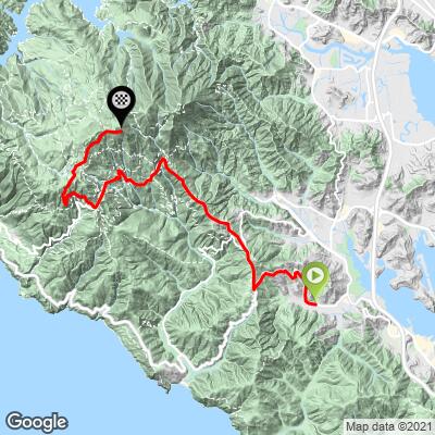
Mt. Tam via  Hwy 1 South Bike Climb - PJAMM Cycling

3.5
FIETS
10.3 mi
DISTANCE
2,675 ft
GAINED
4.6 %
AVG. GRADE

FULL CLIMB STATS

INTRO

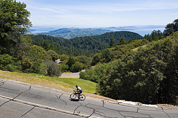
This climb is one of the five primary routes in Marin County to the top of Mt. Tamalpais. Mt. Tamalpais is the highest peak in the Marin County and has two peaks - the East Peak (2,574') and West Peak (2,563'). The white radar dome that sits upon Mt. Tam's slightly lower western peak is quite discernible from afar. An exceptionally scenic and unique riding opportunity is to ride from the Golden Gate Bridge to the top of Mt. Tam.

See our Adventure App for Mt. Tam routes as well as other great preloaded trips in the Bay Area, California, USA and the World below. 
The average grade of this one is 4.5% (5.7% for climb only).  52% of the climb is at 5-10% and 4% is at 10-15%.  The steepest quarter-mile is 9.2%.

See more details and tools regarding this climb's grade via the “Profile Tool” button.
Roadway:  Two lane with center double yellow line the entire ride.   There is no shoulder and the road is in good condition. 

Traffic:  The first 7.3 miles on Shoreline (Highway 1) and Panoramic Highways has moderate traffic, and the final three miles on Pantoll Road and Ridgecrest Boulevard has light traffic. 

Parking:  At the mall in Mill Valley on 6/10 of a mile from the start of the climb (Map; Street View).
Provisions:  None on the route but plenty in Mill Valley where the climb begins. 
Before heading out on any cycling adventure check out our Things to Bring on a Cycling Trip and use our interactive check list to ensure you don't forget anything.
Consider riding across the Golden Gate and up to the top of Mt. Tam and back - Golden Gate - Mt. Tam.  Also see our PJAMM Marin County climb page for more information.

From Mt. Tam's East Peak we can see the Farallon Islands, Marin County hills, San Francisco Bay and City, Angel Island, the Bay Bridge, East Bay, Mt. Diablo, and on a rare crystal clear day the snow capped Sierra Mountains 150 miles east (Google Street View).  There is also a Visitor Center and Gravity Barn at the East Peak. You can get information, history, water, and snacks at the East Peak Visitor Center. Also visit the Gravity Barn Museum which is a tribute to the old railway that climbed Mt. Tam.

ROUTE MAP

MEMBER RATING

Not Yet Rated
-
Road
-
Traffic
-
Scenery

CURRENT WEATHER

PJAMM TRIPS ADVENTURE STARTER BUNDLES

Check out PJAMM Adventure's prepackaged (self-guided) cycling trips. They will help you plan, document and conquer your next adventure.
ALL TRIPS
Browse all of our prepackaged trips and find your next adventure!
Mount Tamalpais
United States (CA)
8 ROUTES
0 POIs
ROUTE STATS (TOTAL)
100
mi
DISTANCE
21,416
ft
ELEV. GAIN
San Francisco Bay Area
United States (CA)
25 ROUTES
30 POIs
ROUTE STATS (TOTAL)
487.9
mi
DISTANCE
65,482
ft
ELEV. GAIN
San Francisco Bay Area: Most Scenic Bike Climbs
United States (CA)
10 ROUTES
0 POIs
ROUTE STATS (TOTAL)
86.9
mi
DISTANCE
25,759
ft
ELEV. GAIN
Sonoma County
United States (CA)
19 ROUTES
39 POIs
ROUTE STATS (TOTAL)
269.3
mi
DISTANCE
41,801
ft
ELEV. GAIN

NEARBY CLIMBS (0) RADIAL PROXIMITY

FROM
No Climbs Found

MEMBER REVIEWS & COMMENTS

Let us know what you thought of this climb. Signup for our FREE membership to write a review or post a comment.
Already have an account?
ROUTE MAP
PROFILE TOOL
Route Data
S.G. (%)
hide
Segment Data
hide

Climb Profile Not Found
CLIMB SUMMARY

Cycling Mt. Tamalpais from Panoramic Highway South - cyclist climbing up two-lane roadway overlooking ocean

Cycling Mt. Tamalpais via Panoramic Highway South

View from Pan Toll Road South

Ride 10.3 miles gaining 2,724’ at 4.7% average grade.

Climb to Mt. Tam West Peak

Strava Attempts as of 2-1-2023

From Alpine Dam

31,122

From Miller Ave

26,755

From Fairfax Bolinas Road

8,735

From Hwy 1 South

7,603

From Panoramic Hwy

7,195

From Marion Ave

3872

From Muir Woods

863

                Popularity of top routes up Mt. Tam

Before heading to the bay area on your cycling adventure, be sure to rely on our list of Things to Bring on a Cycling Trip, and use our interactive checklist to ensure you don't forget anything.

This climb is one of the four primary routes in Marin County to the top of Mt. Tamalpais.  

Mt. Tamalpais is the highest mountain in the Marin County and has two peaks: the East Peak (2,574') and West Peak (2,563').  The white radar dome that sits upon Mt. Tam's slightly lower western peak is quite discernible from afar.  An exceptionally scenic and unique riding opportunity is to ride from the Golden Gate Bridge to the top of Mt. Tam (see details at GGB page).

Cycling Mt. Tamalpais from Panoramic Highway South - photo collage, PJAMM Cycling logo in corner, signs for Mt. Tamalpais State Park and Rock Spring Mountain Theatre, two cyclists standing with bikes on cliffside overlooking ocean waving at camera, aerial view of cyclist on roadside climbing along road

This climb is divided into three parts:

  1. Highway 1/Panoramic Highway to Pantoll Road:   This is the least strenuous of the three segments to the top of Mt. Tam at 7.3 miles, 1,718’ at 3.9%.  Along this route we have views of the West Peak of Mt. Tam, the distant Pacific Ocean, a brief glimpse of the white radar dome we will end just below, and finally wooded borders to the roadway.  We end this segment at Pantoll Campground and Mt. Tamalpais State Park.  ​There is a Visitor Center here where information about the area and maps are gladly dispensed by the rangers.

Cycling Mt. Tamalpais from Panoramic Highway South - bike parked next to California State Parks/National Park Service sign for Mt. Tamalpais State Park along roadside

Mile 2.2 (just after turning onto Panoramic Highway).

Cycling Mt. Tamalpais from Panoramic Highway South - photo collage, PJAMM Cycling logo in corner, bike parked against various roadsigns along the climb route, map of climb route and climb gradient 

Working our way up the mountain.

Cycling Mt. Tamalpais from Panoramic Highway South - photo collage, PJAMM Cycling logo in corner, views from peak overlooking evergreen trees and ridgleines

Cycling Mt. Tamalpais from Panoramic Highway South - photo collage, PJAMM Cycling logo in corner, view from Ridgecrest Boulevard of mountain with Dome on top, up close view of white dome with bike parked below it 

Top left: Dome as seen from Ridgecrest Boulevard (from Alpine Dam and Fairfax-Bolinas routes)

Bottom left: Dome as seen from Panoramic Highway (north/south) and Muir Woods routes.

Cycling Mt. Tamalpais from Panoramic Highway South - photo collage, PJAMM Cycling logo in corner, bike parked against various signs along climb route, foggy day

Bootjack Campground mile 7.  Intersection of Shoreline and Pantoll Road at mile 7.3.

Turn right onto Pantoll Road at the intersection.

  1. Pantol Road to Rock Springs: The second leg is up Pantoll Road from its intersection with Panoramic Highway, to Rock Springs Parking Area (staging area for many television commercial shoots, often for cars and trucks).  Along this route we have great views down to the Pacific Ocean and near the top of Mt. Diablo, San Francisco Bay, and San Francisco.  This segment is 1.4 miles / 490' / 6.2%.

Cycling Mt. Tamalpais from Panoramic Highway South - aerial drone view of two cyclists wearing PJAMM Cycling jerseys and holding their bikes, waving at camera, standing along roadside overlooking rolling hills covered in forestation and ocean beyond

Cycling Mt. Tamalpais from Panoramic Highway South - view of sloping hillsides, overlooking forested areas with ocean beyond

Junction of Pantoll Road and Ridgecrest Boulevard

  1. Ridgecrest Boulevard East: The final leg along Ridgecrest Boulevard East is the easiest section, giving us more spectacular views of Mt. Diablo, San Francisco Bay, and San Francisco.  This segment ends as Ridgecrest "crests" just east of the radio dome atop Mt. Tam’s West Peak and is 1.5 miles /510’ / 6.8%.

Cycling Mt. Tamalpais from Panoramic Highway South - aerial view of San Francisco bay and green forested hillsides surrounding     

Cycling Mt. Tamalpais from Panoramic Highway South - aerial view of Golden Gate Bridge and San Francisco Bay at sunset

Make this climb part of your Bay Area vacation.

That’s a wrap!!