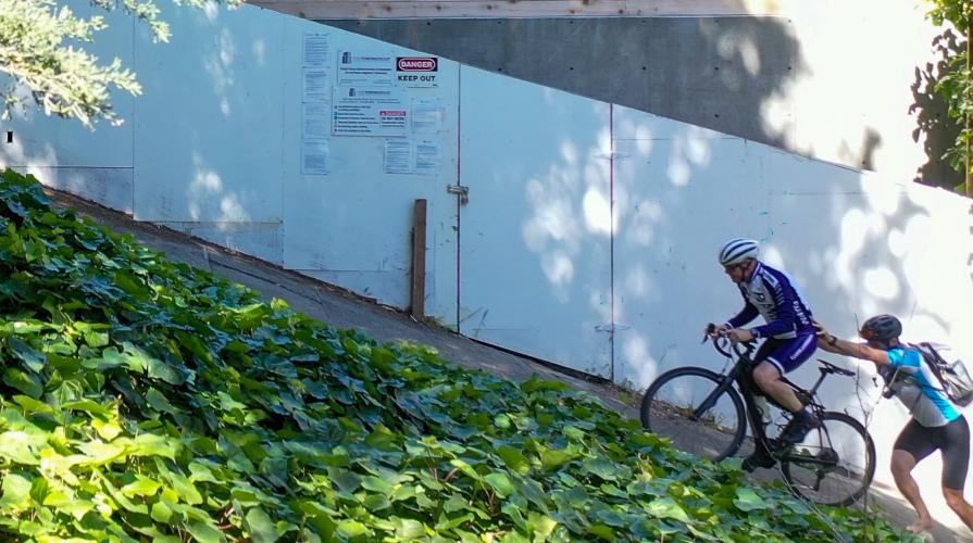
Baker St. above Vallejo Bike Climb - PJAMM Cycling

0.8
FIETS
0.04 mi
DISTANCE
74 ft
GAINED
36.4 %
AVG. GRADE

FULL CLIMB STATS

INTRO

Ok - this is technically a sidewalk. You'll have to walk your bike up stairs to get to it. And there's no flat ground to actually get on your bike and start the climb, so we definitely recommend doing this with a buddy. But if you're brave enough... this is, in our opinion, absolutely the steepest climb in all of San Francisco. In fact, so steep we broke a Zipp hub....

Click here to check out more of the steepest streets in San Francisco

See more details and tools regarding this climb's grade via our interactive Profile Tool.
Roadway:
Concrete sidewalk preceded by stairs

Parking:
Street parking on Vallejo St and Broadway St
Information Not Available

If you have any information regarding this climb, we'd like to hear from you. Click the CONTRIBUTE button to share your thoughts with us.

Before heading out on any cycling adventure check out our Things to Bring on a Cycling Trip and use our interactive check list to ensure you don't forget anything.
We love San Francisco. The combination of legendary steepness, good food, and tons of great sightseeing makes this an awesome city to cycle in. Just outside the city are some of the most popular cycling climbs in America, like Mt. TamMt. DiabloHawk Hill, and Mt. Umunhum, making the Bay area one of the best cycling destinations in the country.  
Check out hotels or rentals in San Francisco to plan your cycling trip!

Here are some good places in the neighborhood of Baker Street:

ROUTE MAP

MEMBER RATING

Not Yet Rated
-
Road
-
Traffic
-
Scenery

CURRENT WEATHER

PJAMM TRIPS ADVENTURE STARTER BUNDLES

Check out PJAMM Adventure's prepackaged (self-guided) cycling trips. They will help you plan, document and conquer your next adventure.
ALL TRIPS
Browse all of our prepackaged trips and find your next adventure!
San Francisco Bay Area
United States (CA)
25 ROUTES
30 POIs
ROUTE STATS (TOTAL)
487.9
mi
DISTANCE
65,482
ft
ELEV. GAIN
San Francisco's Steepest Streets
United States (CA)
20 ROUTES
21 POIs
ROUTE STATS (TOTAL)
0.8
mi
DISTANCE
964
ft
ELEV. GAIN

NEARBY CLIMBS (0) RADIAL PROXIMITY

FROM
No Climbs Found

MEMBER REVIEWS & COMMENTS

Let us know what you thought of this climb. Signup for our FREE membership to write a review or post a comment.
Already have an account?
ROUTE MAP
PROFILE TOOL
Route Data
S.G. (%)
hide
Segment Data
hide

Climb Profile Not Found
CLIMB SUMMARY

This climb is laughably steep. You can tell it used to be a staircase, and was only flattened out so construction equipment could be brought down (we don’t know how it was) to the apartment behind the white boards. No sane human being should attempt this on their bike. But fortunately for us, PJAMM is not made up of sane human beings.

This climb is really, really steep…

So steep that I had to take off my cleats so I wouldn't slip while helping hold John up to get him started!

 Round 2!

We highly recommend doing this climb with a buddy…

“I am NOT doing that again” - John says, shortly before we go back down to climb it again to get more photos

Broken Zipp hub 😢

But worth it for the footage!

You'll have to walk up a staircase to get to this climb - but don’t miss out on the Lower Baker Street climb leading up to it - a brutal 31% average grade.


The hardest part about this climb is getting started - there’s no flat ground to get clipped in. You’ll either have to lose the cleats, have a buddy hold you up (like us), or do something miraculous to get started up this monster.

Access to full Climb Summary requires a PJAMM Cycling PRO Membership!

It takes less than a minute to sign up & with your PRO membership you can:
  • Rate climbs, post comments and share your experiences on any of our climb pages
  • Create bucket lists of climbs & mark the dates you complete them
  • Weather data for all climbs - Start & Finish
  • Upload photos to your member page to customize your PJAMM Cycling experience
  • Utilize all of our interactive tools - Profile & Routes in Area
  • Download climb route .gpx files
LEARN MORE
SIGN UP

Already have an account? LOG IN HERE