
21.7
PDI
6.6 mi
DISTANCE
2,972 ft
GAINED
8.5 %
AVG. GRADE
FULL CLIMB STATS
INTRO
PLAN YOUR ROUTE
 We've partnered with Sherpa-Map.com to bring you the best route planning tool. With a PRO Membership you can use this climb as a reference when creating your route.
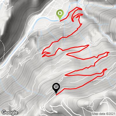
 The average grade is 8.5% over 10.7 km (6.6 mi). There is almost no easy road: the steepest 0.5 km (0.3 mi) averages 13.4%, the steepest kilometer (0.6 mi) 12.0%, the steepest 5 km (3.1 mi) 9.3%, and the steepest 10 km (6.2 mi) 8.7%.
Because the hard sections are spread through the whole climb rather than bunched in one place, it rewards steady pacing and low gearing from the first ramp.
Roadway: The road is paved the whole way and is narrow, cut into the cliff face above the valley. Riders describe the asphalt as recently resurfaced and in very good condition. Loose stones can fall from the rock faces onto the road, so stay alert, especially on the descent.
Traffic: Light. This is a local road serving the hamlet of Montfort and the slopes above it, not a through route.
Parking: Saint-Marcel is a small village of about 600 residents on the Isère valley floor between Moûtiers and Bourg-Saint-Maurice. Riders arriving by train can use the station in Moûtiers, 5 km (3.1 mi) down the valley, and ride to the start.
Provisions: Riders report a drinking-water fountain at a switchback in the hamlet of Montfort, about halfway up. The Auberge de Montfort in the hamlet has a terrace facing the Lauzière massif, which makes a good stop on the way down.
Gear: With an 8.5% average and long stretches above 10%, compact gearing and a wide-range cassette make the climb far more comfortable. Much of the road is shaded, so a light layer is worth carrying for the descent.
Before heading out on any cycling adventure check out our Things to Bring on a Cycling Trip and use our interactive check list to ensure you don't forget anything.
Saint-Marcel is small but has a few things worth a stop. The neo-Gothic chapel of Saint-Jacques (built 1898-1903 on the Roc Puppin from the stones of the old castle) sits above the village, and the Pomblière factory in the valley launched France's first high-voltage transmission line in 1906, carrying power to the Lyon tramway. Moûtiers, 5 km (3.1 mi) down the valley, is the area's cathedral town and transit hub, with hotels, restaurants and shops.
In the hamlet itself, look for the old oven, the press and the church, and the Auberge de Montfort's terrace, which looks across to the Lauzière massif. To ride a second climb from the same base, see Val Thorens, which starts in Moûtiers, or La Quermoz Sud on the far side of the valley.
To see other climbs nearby, or build a custom route from here, try our Routes in the Area tool.
ROUTE MAP
MEMBER RATING
CURRENT WEATHER
PJAMM TRIPS ADVENTURE STARTER BUNDLES
Check out PJAMM Adventure's prepackaged (self-guided) cycling trips. They will help you plan, document and conquer your next adventure.
NEARBY CLIMBS (0) RADIAL PROXIMITY
FROM No Climbs Found
MEMBER REVIEWS & COMMENTS
Let us know what you thought of this climb. Signup for our FREE membership to write a review or post a comment.
Already have an account?
LOG IN HERE
